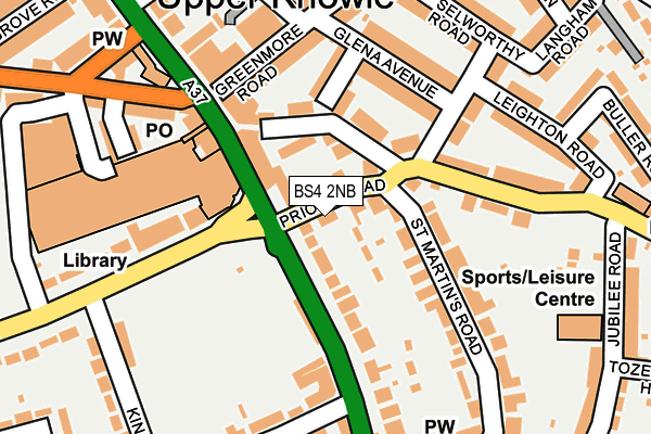
BS4 2NB is located in the Knowle electoral ward, within the unitary authority of Bristol, City of and the English Parliamentary constituency of Bristol South. The Sub Integrated Care Board (ICB) Location is NHS Bristol, North Somerset and South Gloucestershire ICB - 15C and the police force is Avon and Somerset. This postcode has been in use since December 2001.


GetTheData
Source: OS OpenMap – Local (Ordnance Survey)
Source: OS VectorMap District (Ordnance Survey)
Licence: Open Government Licence (requires attribution)
| Easting | 360779 |
| Northing | 170719 |
| Latitude | 51.434104 |
| Longitude | -2.565602 |
GetTheData
Source: Open Postcode Geo
Licence: Open Government Licence
| Country | England |
| Postcode District | BS4 |
➜ See where BS4 is on a map ➜ Where is Bristol? | |
GetTheData
Source: Land Registry Price Paid Data
Licence: Open Government Licence
Elevation or altitude of BS4 2NB as distance above sea level:
| Metres | Feet | |
|---|---|---|
| Elevation | 70m | 230ft |
Elevation is measured from the approximate centre of the postcode, to the nearest point on an OS contour line from OS Terrain 50, which has contour spacing of ten vertical metres.
➜ How high above sea level am I? Find the elevation of your current position using your device's GPS.
GetTheData
Source: Open Postcode Elevation
Licence: Open Government Licence
| Ward | Knowle |
| Constituency | Bristol South |
GetTheData
Source: ONS Postcode Database
Licence: Open Government Licence
| Priory Road | Knowle | 38m |
| Broad Walk Shops | Knowle | 108m |
| Broad Wlk Shops | Knowle | 114m |
| Broad Walk Shops (Broad Walk) | Knowle | 131m |
| Greenmore Road (Wells Road) | Knowle | 136m |
| Bristol Temple Meads Station | 2km |
| Bedminster Station | 2.1km |
| Lawrence Hill Station | 2.7km |
GetTheData
Source: NaPTAN
Licence: Open Government Licence
| Percentage of properties with Next Generation Access | 100.0% |
| Percentage of properties with Superfast Broadband | 100.0% |
| Percentage of properties with Ultrafast Broadband | 0.0% |
| Percentage of properties with Full Fibre Broadband | 0.0% |
Superfast Broadband is between 30Mbps and 300Mbps
Ultrafast Broadband is > 300Mbps
| Percentage of properties unable to receive 2Mbps | 0.0% |
| Percentage of properties unable to receive 5Mbps | 0.0% |
| Percentage of properties unable to receive 10Mbps | 0.0% |
| Percentage of properties unable to receive 30Mbps | 0.0% |
GetTheData
Source: Ofcom
Licence: Ofcom Terms of Use (requires attribution)
GetTheData
Source: ONS Postcode Database
Licence: Open Government Licence


➜ Get more ratings from the Food Standards Agency
GetTheData
Source: Food Standards Agency
Licence: FSA terms & conditions
| Last Collection | |||
|---|---|---|---|
| Location | Mon-Fri | Sat | Distance |
| Crossways Road | 17:00 | 11:45 | 185m |
| Knowle Post Office | 18:00 | 12:00 | 193m |
| Talbot/Jubilee Road | 16:00 | 11:30 | 261m |
GetTheData
Source: Dracos
Licence: Creative Commons Attribution-ShareAlike
The below table lists the International Territorial Level (ITL) codes (formerly Nomenclature of Territorial Units for Statistics (NUTS) codes) and Local Administrative Units (LAU) codes for BS4 2NB:
| ITL 1 Code | Name |
|---|---|
| TLK | South West (England) |
| ITL 2 Code | Name |
| TLK1 | Gloucestershire, Wiltshire and Bath/Bristol area |
| ITL 3 Code | Name |
| TLK11 | Bristol, City of |
| LAU 1 Code | Name |
| E06000023 | Bristol, City of |
GetTheData
Source: ONS Postcode Directory
Licence: Open Government Licence
The below table lists the Census Output Area (OA), Lower Layer Super Output Area (LSOA), and Middle Layer Super Output Area (MSOA) for BS4 2NB:
| Code | Name | |
|---|---|---|
| OA | E00073984 | |
| LSOA | E01014651 | Bristol 042E |
| MSOA | E02003053 | Bristol 042 |
GetTheData
Source: ONS Postcode Directory
Licence: Open Government Licence
| BS4 2NF | Priory Road | 52m |
| BS4 2NE | Talbot Road | 66m |
| BS4 2QG | Wells Road | 95m |
| BS4 2NA | Talbot Road | 106m |
| BS4 2QL | Wells Road | 112m |
| BS4 2QB | Wells Road | 128m |
| BS4 2LD | Merfield Road | 131m |
| BS4 2LB | Glena Avenue | 135m |
| BS4 2NG | St Martins Road | 140m |
| BS4 2LA | Greenmore Road | 147m |
GetTheData
Source: Open Postcode Geo; Land Registry Price Paid Data
Licence: Open Government Licence