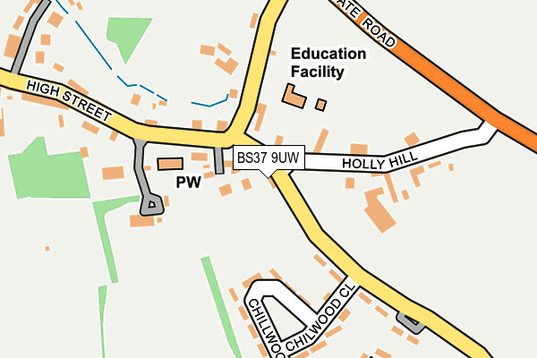
BS37 9UW lies on Nibley Lane in Iron Acton, Bristol. BS37 9UW is located in the Frampton Cotterell electoral ward, within the unitary authority of South Gloucestershire and the English Parliamentary constituency of Thornbury and Yate. The Sub Integrated Care Board (ICB) Location is NHS Bristol, North Somerset and South Gloucestershire ICB - 15C and the police force is Avon and Somerset. This postcode has been in use since December 1997.


GetTheData
Source: OS OpenMap – Local (Ordnance Survey)
Source: OS VectorMap District (Ordnance Survey)
Licence: Open Government Licence (requires attribution)
| Easting | 368178 |
| Northing | 183434 |
| Latitude | 51.548892 |
| Longitude | -2.460319 |
GetTheData
Source: Open Postcode Geo
Licence: Open Government Licence
| Street | Nibley Lane |
| Locality | Iron Acton |
| Town/City | Bristol |
| Country | England |
| Postcode District | BS37 |
➜ See where BS37 is on a map ➜ Where is Iron Acton? | |
GetTheData
Source: Land Registry Price Paid Data
Licence: Open Government Licence
Elevation or altitude of BS37 9UW as distance above sea level:
| Metres | Feet | |
|---|---|---|
| Elevation | 60m | 197ft |
Elevation is measured from the approximate centre of the postcode, to the nearest point on an OS contour line from OS Terrain 50, which has contour spacing of ten vertical metres.
➜ How high above sea level am I? Find the elevation of your current position using your device's GPS.
GetTheData
Source: Open Postcode Elevation
Licence: Open Government Licence
| Ward | Frampton Cotterell |
| Constituency | Thornbury And Yate |
GetTheData
Source: ONS Postcode Database
Licence: Open Government Licence
2016 6 OCT £332,500 |
2014 11 JUN £290,000 |
GetTheData
Source: HM Land Registry Price Paid Data
Licence: Contains HM Land Registry data © Crown copyright and database right 2024. This data is licensed under the Open Government Licence v3.0.
| The Lamb Inn (Wotton Road) | Iron Acton | 113m |
| The Lamb Inn (Wotton Road) | Iron Acton | 138m |
| Parish Hall (High Street) | Iron Acton | 310m |
| Parish Hall (High Street) | Iron Acton | 334m |
| The White Hart (Station Road) | Iron Acton | 526m |
| Yate Station | 2.1km |
GetTheData
Source: NaPTAN
Licence: Open Government Licence
| Percentage of properties with Next Generation Access | 100.0% |
| Percentage of properties with Superfast Broadband | 100.0% |
| Percentage of properties with Ultrafast Broadband | 0.0% |
| Percentage of properties with Full Fibre Broadband | 0.0% |
Superfast Broadband is between 30Mbps and 300Mbps
Ultrafast Broadband is > 300Mbps
| Percentage of properties unable to receive 2Mbps | 0.0% |
| Percentage of properties unable to receive 5Mbps | 0.0% |
| Percentage of properties unable to receive 10Mbps | 0.0% |
| Percentage of properties unable to receive 30Mbps | 0.0% |
GetTheData
Source: Ofcom
Licence: Ofcom Terms of Use (requires attribution)
GetTheData
Source: ONS Postcode Database
Licence: Open Government Licence


➜ Get more ratings from the Food Standards Agency
GetTheData
Source: Food Standards Agency
Licence: FSA terms & conditions
| Last Collection | |||
|---|---|---|---|
| Location | Mon-Fri | Sat | Distance |
| The School | 16:45 | 09:30 | 99m |
| Chilwood Close | 16:15 | 09:30 | 194m |
| Latteridge Road Iron Acton | 16:45 | 09:30 | 546m |
GetTheData
Source: Dracos
Licence: Creative Commons Attribution-ShareAlike
The below table lists the International Territorial Level (ITL) codes (formerly Nomenclature of Territorial Units for Statistics (NUTS) codes) and Local Administrative Units (LAU) codes for BS37 9UW:
| ITL 1 Code | Name |
|---|---|
| TLK | South West (England) |
| ITL 2 Code | Name |
| TLK1 | Gloucestershire, Wiltshire and Bath/Bristol area |
| ITL 3 Code | Name |
| TLK12 | Bath and North East Somerset, North Somerset and South Gloucestershire |
| LAU 1 Code | Name |
| E06000025 | South Gloucestershire |
GetTheData
Source: ONS Postcode Directory
Licence: Open Government Licence
The below table lists the Census Output Area (OA), Lower Layer Super Output Area (LSOA), and Middle Layer Super Output Area (MSOA) for BS37 9UW:
| Code | Name | |
|---|---|---|
| OA | E00075430 | |
| LSOA | E01014929 | South Gloucestershire 003C |
| MSOA | E02003092 | South Gloucestershire 003 |
GetTheData
Source: ONS Postcode Directory
Licence: Open Government Licence
| BS37 9UN | Holly Hill | 41m |
| BS37 9UL | Prospect Cottages | 43m |
| BS37 9UZ | Wotton Road | 105m |
| BS37 9XZ | Holly Hill | 143m |
| BS37 9US | Chilwood Close | 187m |
| BS37 9UP | Nibley Lane | 189m |
| BS37 9UT | Algars Drive | 239m |
| BS37 9UQ | High Street | 257m |
| BS37 9UH | High Street | 268m |
| BS37 9YA | Yate Road | 354m |
GetTheData
Source: Open Postcode Geo; Land Registry Price Paid Data
Licence: Open Government Licence