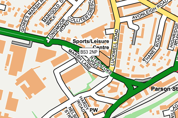
BS3 2NP lies on Winterstoke Road in Bristol. BS3 2NP is located in the Bedminster electoral ward, within the unitary authority of Bristol, City of and the English Parliamentary constituency of Bristol South. The Sub Integrated Care Board (ICB) Location is NHS Bristol, North Somerset and South Gloucestershire ICB - 15C and the police force is Avon and Somerset. This postcode has been in use since January 1980.


GetTheData
Source: OS OpenMap – Local (Ordnance Survey)
Source: OS VectorMap District (Ordnance Survey)
Licence: Open Government Licence (requires attribution)
| Easting | 357556 |
| Northing | 170687 |
| Latitude | 51.433582 |
| Longitude | -2.611963 |
GetTheData
Source: Open Postcode Geo
Licence: Open Government Licence
| Street | Winterstoke Road |
| Town/City | Bristol |
| Country | England |
| Postcode District | BS3 |
➜ See where BS3 is on a map ➜ Where is Bristol? | |
GetTheData
Source: Land Registry Price Paid Data
Licence: Open Government Licence
Elevation or altitude of BS3 2NP as distance above sea level:
| Metres | Feet | |
|---|---|---|
| Elevation | 20m | 66ft |
Elevation is measured from the approximate centre of the postcode, to the nearest point on an OS contour line from OS Terrain 50, which has contour spacing of ten vertical metres.
➜ How high above sea level am I? Find the elevation of your current position using your device's GPS.
GetTheData
Source: Open Postcode Elevation
Licence: Open Government Licence
| Ward | Bedminster |
| Constituency | Bristol South |
GetTheData
Source: ONS Postcode Database
Licence: Open Government Licence
| Marsh Lane (Luckwell Road) | Ashton Vale | 54m |
| Marsh Lane (Winterstoke Road) | Ashton Vale | 121m |
| Bedminster Down Road | Bedminster Down | 210m |
| Parson Street | Bedminster | 256m |
| Luckwell Road | Bedminster | 267m |
| Parson Street Station | 0.3km |
| Bedminster Station | 1.4km |
| Bristol Temple Meads Station | 2.7km |
GetTheData
Source: NaPTAN
Licence: Open Government Licence
GetTheData
Source: ONS Postcode Database
Licence: Open Government Licence


➜ Get more ratings from the Food Standards Agency
GetTheData
Source: Food Standards Agency
Licence: FSA terms & conditions
| Last Collection | |||
|---|---|---|---|
| Location | Mon-Fri | Sat | Distance |
| Ilchester Crescent | 16:00 | 11:30 | 331m |
| Luckwell Road | 16:45 | 12:15 | 405m |
| Liberty Business Park | 18:30 | 463m | |
GetTheData
Source: Dracos
Licence: Creative Commons Attribution-ShareAlike
The below table lists the International Territorial Level (ITL) codes (formerly Nomenclature of Territorial Units for Statistics (NUTS) codes) and Local Administrative Units (LAU) codes for BS3 2NP:
| ITL 1 Code | Name |
|---|---|
| TLK | South West (England) |
| ITL 2 Code | Name |
| TLK1 | Gloucestershire, Wiltshire and Bath/Bristol area |
| ITL 3 Code | Name |
| TLK11 | Bristol, City of |
| LAU 1 Code | Name |
| E06000023 | Bristol, City of |
GetTheData
Source: ONS Postcode Directory
Licence: Open Government Licence
The below table lists the Census Output Area (OA), Lower Layer Super Output Area (LSOA), and Middle Layer Super Output Area (MSOA) for BS3 2NP:
| Code | Name | |
|---|---|---|
| OA | E00073250 | |
| LSOA | E01014500 | Bristol 039A |
| MSOA | E02003050 | Bristol 039 |
GetTheData
Source: ONS Postcode Directory
Licence: Open Government Licence
| BS3 2NR | Marsh Lane | 30m |
| BS3 2NQ | Winterstoke Road | 76m |
| BS3 2NN | Winterstoke Road | 77m |
| BS3 2SQ | South Liberty Lane | 78m |
| BS3 2BQ | Alma Place | 99m |
| BS3 2SJ | South Liberty Lane | 106m |
| BS3 2SL | Alma Cottages | 106m |
| BS3 3HD | Luckwell Road | 106m |
| BS3 2NW | Winterstoke Road | 109m |
| BS3 2SN | Hardy Road | 124m |
GetTheData
Source: Open Postcode Geo; Land Registry Price Paid Data
Licence: Open Government Licence