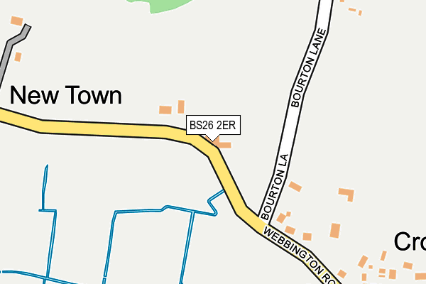
BS26 2ER lies on Webbington Road in Compton Bishop, Axbridge. BS26 2ER is located in the Brent electoral ward, within the unitary authority of Somerset and the English Parliamentary constituency of Wells. The Sub Integrated Care Board (ICB) Location is NHS Somerset ICB - 11X and the police force is Avon and Somerset. This postcode has been in use since January 1980.


GetTheData
Source: OS OpenMap – Local (Ordnance Survey)
Source: OS VectorMap District (Ordnance Survey)
Licence: Open Government Licence (requires attribution)
| Easting | 340924 |
| Northing | 155010 |
| Latitude | 51.291139 |
| Longitude | -2.848589 |
GetTheData
Source: Open Postcode Geo
Licence: Open Government Licence
| Street | Webbington Road |
| Locality | Compton Bishop |
| Town/City | Axbridge |
| Country | England |
| Postcode District | BS26 |
➜ See where BS26 is on a map ➜ Where is New Town? | |
GetTheData
Source: Land Registry Price Paid Data
Licence: Open Government Licence
Elevation or altitude of BS26 2ER as distance above sea level:
| Metres | Feet | |
|---|---|---|
| Elevation | 10m | 33ft |
Elevation is measured from the approximate centre of the postcode, to the nearest point on an OS contour line from OS Terrain 50, which has contour spacing of ten vertical metres.
➜ How high above sea level am I? Find the elevation of your current position using your device's GPS.
GetTheData
Source: Open Postcode Elevation
Licence: Open Government Licence
| Ward | Brent |
| Constituency | Wells |
GetTheData
Source: ONS Postcode Database
Licence: Open Government Licence
| Crossways House (Old Coach Road) | Cross | 363m |
| The Bus Shelter (Old Coach Road) | Cross | 399m |
| The Bus Shelter (Webbington Road) | Rackley | 620m |
| The White Hart (Old Coach Road) | Cross | 775m |
| The White Hart (Old Coach Road) | Cross | 802m |
GetTheData
Source: NaPTAN
Licence: Open Government Licence
| Percentage of properties with Next Generation Access | 100.0% |
| Percentage of properties with Superfast Broadband | 0.0% |
| Percentage of properties with Ultrafast Broadband | 0.0% |
| Percentage of properties with Full Fibre Broadband | 0.0% |
Superfast Broadband is between 30Mbps and 300Mbps
Ultrafast Broadband is > 300Mbps
| Median download speed | 13.2Mbps |
| Average download speed | 10.9Mbps |
| Maximum download speed | 14.26Mbps |
| Median upload speed | 1.0Mbps |
| Average upload speed | 0.9Mbps |
| Maximum upload speed | 1.17Mbps |
| Percentage of properties unable to receive 2Mbps | 0.0% |
| Percentage of properties unable to receive 5Mbps | 0.0% |
| Percentage of properties unable to receive 10Mbps | 0.0% |
| Percentage of properties unable to receive 30Mbps | 100.0% |
GetTheData
Source: Ofcom
Licence: Ofcom Terms of Use (requires attribution)
Estimated total energy consumption in BS26 2ER by fuel type, 2015.
| Consumption (kWh) | 80,619 |
|---|---|
| Meter count | 6 |
| Mean (kWh/meter) | 13,437 |
| Median (kWh/meter) | 10,375 |
| Consumption (kWh) | 36,548 |
|---|---|
| Meter count | 9 |
| Mean (kWh/meter) | 4,061 |
| Median (kWh/meter) | 4,529 |
GetTheData
Source: Postcode level gas estimates: 2015 (experimental)
Source: Postcode level electricity estimates: 2015 (experimental)
Licence: Open Government Licence
GetTheData
Source: ONS Postcode Database
Licence: Open Government Licence


➜ Get more ratings from the Food Standards Agency
GetTheData
Source: Food Standards Agency
Licence: FSA terms & conditions
| Last Collection | |||
|---|---|---|---|
| Location | Mon-Fri | Sat | Distance |
| Allerton Post Office | 16:30 | 09:15 | 1,582m |
| Allerton Cross | 15:45 | 10:00 | 1,907m |
| New Moon | 16:00 | 08:30 | 2,268m |
GetTheData
Source: Dracos
Licence: Creative Commons Attribution-ShareAlike
The below table lists the International Territorial Level (ITL) codes (formerly Nomenclature of Territorial Units for Statistics (NUTS) codes) and Local Administrative Units (LAU) codes for BS26 2ER:
| ITL 1 Code | Name |
|---|---|
| TLK | South West (England) |
| ITL 2 Code | Name |
| TLK2 | Dorset and Somerset |
| ITL 3 Code | Name |
| TLK23 | Somerset CC |
| LAU 1 Code | Name |
| E07000188 | Sedgemoor |
GetTheData
Source: ONS Postcode Directory
Licence: Open Government Licence
The below table lists the Census Output Area (OA), Lower Layer Super Output Area (LSOA), and Middle Layer Super Output Area (MSOA) for BS26 2ER:
| Code | Name | |
|---|---|---|
| OA | E00148141 | |
| LSOA | E01029086 | Sedgemoor 003A |
| MSOA | E02006063 | Sedgemoor 003 |
GetTheData
Source: ONS Postcode Directory
Licence: Open Government Licence
| BS26 2EP | Bourton Lane | 140m |
| BS26 2EL | Webbington Road | 265m |
| BS26 2EU | Webbington Road | 342m |
| BS26 2EH | Old Coach Road | 424m |
| BS26 2EG | Old Coach Road | 545m |
| BS26 2EJ | Old Coach Road | 551m |
| BS26 2EQ | Old Coach Road | 562m |
| BS26 2JA | 654m | |
| BS26 2EX | Webbington Road | 676m |
| BS26 2FE | Springfield Close | 731m |
GetTheData
Source: Open Postcode Geo; Land Registry Price Paid Data
Licence: Open Government Licence