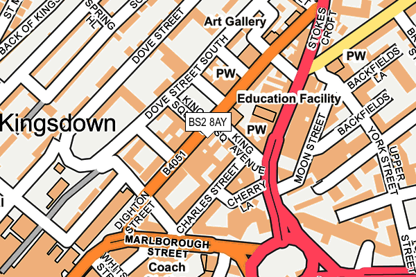
BS2 8AY is located in the Central electoral ward, within the unitary authority of Bristol, City of and the English Parliamentary constituency of Bristol West. The Sub Integrated Care Board (ICB) Location is NHS Bristol, North Somerset and South Gloucestershire ICB - 15C and the police force is Avon and Somerset. This postcode has been in use since October 2010.


GetTheData
Source: OS OpenMap – Local (Ordnance Survey)
Source: OS VectorMap District (Ordnance Survey)
Licence: Open Government Licence (requires attribution)
| Easting | 358919 |
| Northing | 173703 |
| Latitude | 51.460800 |
| Longitude | -2.592707 |
GetTheData
Source: Open Postcode Geo
Licence: Open Government Licence
| Country | England |
| Postcode District | BS2 |
➜ See where BS2 is on a map ➜ Where is Bristol? | |
GetTheData
Source: Land Registry Price Paid Data
Licence: Open Government Licence
Elevation or altitude of BS2 8AY as distance above sea level:
| Metres | Feet | |
|---|---|---|
| Elevation | 20m | 66ft |
Elevation is measured from the approximate centre of the postcode, to the nearest point on an OS contour line from OS Terrain 50, which has contour spacing of ten vertical metres.
➜ How high above sea level am I? Find the elevation of your current position using your device's GPS.
GetTheData
Source: Open Postcode Elevation
Licence: Open Government Licence
| Ward | Central |
| Constituency | Bristol West |
GetTheData
Source: ONS Postcode Database
Licence: Open Government Licence
| North Street | Kingsdown | 125m |
| Marlborough Street | Kingsdown | 130m |
| Stokes Croft | Kingsdown | 132m |
| The Haymarket | Broadmead | 225m |
| The Haymarket | Broadmead | 236m |
| Montpelier Station | 0.9km |
| Redland Station | 1km |
| Clifton Down Station | 1.4km |
GetTheData
Source: NaPTAN
Licence: Open Government Licence
| Percentage of properties with Next Generation Access | 100.0% |
| Percentage of properties with Superfast Broadband | 100.0% |
| Percentage of properties with Ultrafast Broadband | 0.0% |
| Percentage of properties with Full Fibre Broadband | 0.0% |
Superfast Broadband is between 30Mbps and 300Mbps
Ultrafast Broadband is > 300Mbps
| Percentage of properties unable to receive 2Mbps | 0.0% |
| Percentage of properties unable to receive 5Mbps | 0.0% |
| Percentage of properties unable to receive 10Mbps | 0.0% |
| Percentage of properties unable to receive 30Mbps | 0.0% |
GetTheData
Source: Ofcom
Licence: Ofcom Terms of Use (requires attribution)
GetTheData
Source: ONS Postcode Database
Licence: Open Government Licence


➜ Get more ratings from the Food Standards Agency
GetTheData
Source: Food Standards Agency
Licence: FSA terms & conditions
| Last Collection | |||
|---|---|---|---|
| Location | Mon-Fri | Sat | Distance |
| Kings Square | 17:00 | 11:30 | 64m |
| Marlborough Street | 17:15 | 12:15 | 250m |
| Kingsdown Parade | 17:45 | 12:30 | 315m |
GetTheData
Source: Dracos
Licence: Creative Commons Attribution-ShareAlike
The below table lists the International Territorial Level (ITL) codes (formerly Nomenclature of Territorial Units for Statistics (NUTS) codes) and Local Administrative Units (LAU) codes for BS2 8AY:
| ITL 1 Code | Name |
|---|---|
| TLK | South West (England) |
| ITL 2 Code | Name |
| TLK1 | Gloucestershire, Wiltshire and Bath/Bristol area |
| ITL 3 Code | Name |
| TLK11 | Bristol, City of |
| LAU 1 Code | Name |
| E06000023 | Bristol, City of |
GetTheData
Source: ONS Postcode Directory
Licence: Open Government Licence
The below table lists the Census Output Area (OA), Lower Layer Super Output Area (LSOA), and Middle Layer Super Output Area (MSOA) for BS2 8AY:
| Code | Name | |
|---|---|---|
| OA | E00174041 | |
| LSOA | E01033342 | Bristol 025E |
| MSOA | E02003036 | Bristol 025 |
GetTheData
Source: ONS Postcode Directory
Licence: Open Government Licence
| BS1 3NN | Charles Street | 40m |
| BS2 8HS | Montague Hill South | 51m |
| BS2 8HT | Montague Hill South | 51m |
| BS2 8JD | King Square | 51m |
| BS2 8NQ | Princess Row | 56m |
| BS2 8NY | Montague Street | 57m |
| BS2 8NZ | Montague Street | 57m |
| BS2 8NF | Princess Row | 61m |
| BS2 8HP | King Square Avenue | 76m |
| BS2 8HU | King Square Avenue | 76m |
GetTheData
Source: Open Postcode Geo; Land Registry Price Paid Data
Licence: Open Government Licence