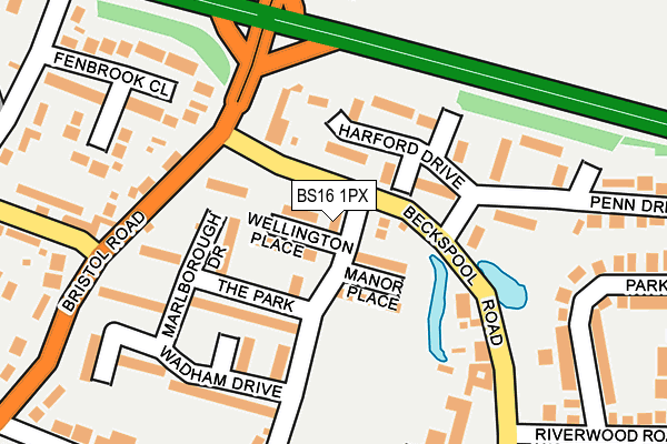
BS16 1PX lies on Malmains Drive in Frenchay, Bristol. BS16 1PX is located in the Frenchay & Downend electoral ward, within the unitary authority of South Gloucestershire and the English Parliamentary constituency of Filton and Bradley Stoke. The Sub Integrated Care Board (ICB) Location is NHS Bristol, North Somerset and South Gloucestershire ICB - 15C and the police force is Avon and Somerset. This postcode has been in use since January 1980.


GetTheData
Source: OS OpenMap – Local (Ordnance Survey)
Source: OS VectorMap District (Ordnance Survey)
Licence: Open Government Licence (requires attribution)
| Easting | 364010 |
| Northing | 178288 |
| Latitude | 51.502373 |
| Longitude | -2.519898 |
GetTheData
Source: Open Postcode Geo
Licence: Open Government Licence
| Street | Malmains Drive |
| Locality | Frenchay |
| Town/City | Bristol |
| Country | England |
| Postcode District | BS16 |
➜ See where BS16 is on a map ➜ Where is Frenchay? | |
GetTheData
Source: Land Registry Price Paid Data
Licence: Open Government Licence
Elevation or altitude of BS16 1PX as distance above sea level:
| Metres | Feet | |
|---|---|---|
| Elevation | 40m | 131ft |
Elevation is measured from the approximate centre of the postcode, to the nearest point on an OS contour line from OS Terrain 50, which has contour spacing of ten vertical metres.
➜ How high above sea level am I? Find the elevation of your current position using your device's GPS.
GetTheData
Source: Open Postcode Elevation
Licence: Open Government Licence
| Ward | Frenchay & Downend |
| Constituency | Filton And Bradley Stoke |
GetTheData
Source: ONS Postcode Database
Licence: Open Government Licence
| Beckspool Road | Frenchay | 57m |
| Beckspool Road | Frenchay | 79m |
| Beckspool Road (Bristol Road) | Frenchay | 145m |
| Beckspool Road (Bristol Road) | Frenchay | 145m |
| Penn Drive | Frenchay | 223m |
| Bristol Parkway Station | 2km |
| Filton Abbey Wood Station | 3km |
| Patchway Station | 4km |
GetTheData
Source: NaPTAN
Licence: Open Government Licence
| Percentage of properties with Next Generation Access | 100.0% |
| Percentage of properties with Superfast Broadband | 100.0% |
| Percentage of properties with Ultrafast Broadband | 100.0% |
| Percentage of properties with Full Fibre Broadband | 0.0% |
Superfast Broadband is between 30Mbps and 300Mbps
Ultrafast Broadband is > 300Mbps
| Percentage of properties unable to receive 2Mbps | 0.0% |
| Percentage of properties unable to receive 5Mbps | 0.0% |
| Percentage of properties unable to receive 10Mbps | 0.0% |
| Percentage of properties unable to receive 30Mbps | 0.0% |
GetTheData
Source: Ofcom
Licence: Ofcom Terms of Use (requires attribution)
GetTheData
Source: ONS Postcode Database
Licence: Open Government Licence
➜ Get more ratings from the Food Standards Agency
GetTheData
Source: Food Standards Agency
Licence: FSA terms & conditions
| Last Collection | |||
|---|---|---|---|
| Location | Mon-Fri | Sat | Distance |
| Hambrook Post Office | 17:15 | 12:00 | 263m |
| Grove House | 17:30 | 12:00 | 300m |
| Hambrook Grove (Old P/Office) | 17:15 | 12:00 | 721m |
GetTheData
Source: Dracos
Licence: Creative Commons Attribution-ShareAlike
The below table lists the International Territorial Level (ITL) codes (formerly Nomenclature of Territorial Units for Statistics (NUTS) codes) and Local Administrative Units (LAU) codes for BS16 1PX:
| ITL 1 Code | Name |
|---|---|
| TLK | South West (England) |
| ITL 2 Code | Name |
| TLK1 | Gloucestershire, Wiltshire and Bath/Bristol area |
| ITL 3 Code | Name |
| TLK12 | Bath and North East Somerset, North Somerset and South Gloucestershire |
| LAU 1 Code | Name |
| E06000025 | South Gloucestershire |
GetTheData
Source: ONS Postcode Directory
Licence: Open Government Licence
The below table lists the Census Output Area (OA), Lower Layer Super Output Area (LSOA), and Middle Layer Super Output Area (MSOA) for BS16 1PX:
| Code | Name | |
|---|---|---|
| OA | E00075768 | |
| LSOA | E01014996 | South Gloucestershire 017C |
| MSOA | E02003106 | South Gloucestershire 017 |
GetTheData
Source: ONS Postcode Directory
Licence: Open Government Licence
| BS16 1PY | Wellington Place | 35m |
| BS16 1PZ | Malmains Drive | 41m |
| BS16 1PU | Wellington Place | 55m |
| BS16 1PT | Malmains Drive | 60m |
| BS16 1NP | Harford Drive | 67m |
| BS16 1PS | Manor Place | 74m |
| BS16 1NR | Harford Drive | 93m |
| BS16 1PP | Marlborough Drive | 97m |
| BS16 1PR | Marlborough Drive | 99m |
| BS16 1QZ | Beckspool Road | 113m |
GetTheData
Source: Open Postcode Geo; Land Registry Price Paid Data
Licence: Open Government Licence