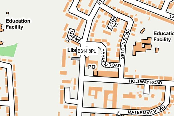
BS14 8PL is located in the Stockwood electoral ward, within the unitary authority of Bristol, City of and the English Parliamentary constituency of Bristol East. The Sub Integrated Care Board (ICB) Location is NHS Bristol, North Somerset and South Gloucestershire ICB - 15C and the police force is Avon and Somerset. This postcode has been in use since January 1980.


GetTheData
Source: OS OpenMap – Local (Ordnance Survey)
Source: OS VectorMap District (Ordnance Survey)
Licence: Open Government Licence (requires attribution)
| Easting | 362034 |
| Northing | 168301 |
| Latitude | 51.412449 |
| Longitude | -2.547289 |
GetTheData
Source: Open Postcode Geo
Licence: Open Government Licence
| Country | England |
| Postcode District | BS14 |
➜ See where BS14 is on a map ➜ Where is Bristol? | |
GetTheData
Source: Land Registry Price Paid Data
Licence: Open Government Licence
Elevation or altitude of BS14 8PL as distance above sea level:
| Metres | Feet | |
|---|---|---|
| Elevation | 90m | 295ft |
Elevation is measured from the approximate centre of the postcode, to the nearest point on an OS contour line from OS Terrain 50, which has contour spacing of ten vertical metres.
➜ How high above sea level am I? Find the elevation of your current position using your device's GPS.
GetTheData
Source: Open Postcode Elevation
Licence: Open Government Licence
| Ward | Stockwood |
| Constituency | Bristol East |
GetTheData
Source: ONS Postcode Database
Licence: Open Government Licence
| Stockwood Library (Stockwood Road) | Stockwood | 29m |
| Hollway Road Shops (Hollway Road) | Whitchurch | 81m |
| Hollway Road Shops (Stockwood Road) | Stockwood | 121m |
| Ladman Road (Stockwood Road) | Stockwood | 207m |
| Ladman Road | Stockwood | 240m |
| Keynsham Station | 3.6km |
| Bedminster Station | 4.5km |
| Bristol Temple Meads Station | 4.7km |
GetTheData
Source: NaPTAN
Licence: Open Government Licence
GetTheData
Source: ONS Postcode Database
Licence: Open Government Licence


➜ Get more ratings from the Food Standards Agency
GetTheData
Source: Food Standards Agency
Licence: FSA terms & conditions
| Last Collection | |||
|---|---|---|---|
| Location | Mon-Fri | Sat | Distance |
| Staunton Lane | 16:45 | 10:00 | 889m |
| Gilda Parade | 17:30 | 12:45 | 904m |
| Davids Road | 16:45 | 11:30 | 961m |
GetTheData
Source: Dracos
Licence: Creative Commons Attribution-ShareAlike
The below table lists the International Territorial Level (ITL) codes (formerly Nomenclature of Territorial Units for Statistics (NUTS) codes) and Local Administrative Units (LAU) codes for BS14 8PL:
| ITL 1 Code | Name |
|---|---|
| TLK | South West (England) |
| ITL 2 Code | Name |
| TLK1 | Gloucestershire, Wiltshire and Bath/Bristol area |
| ITL 3 Code | Name |
| TLK11 | Bristol, City of |
| LAU 1 Code | Name |
| E06000023 | Bristol, City of |
GetTheData
Source: ONS Postcode Directory
Licence: Open Government Licence
The below table lists the Census Output Area (OA), Lower Layer Super Output Area (LSOA), and Middle Layer Super Output Area (MSOA) for BS14 8PL:
| Code | Name | |
|---|---|---|
| OA | E00074271 | |
| LSOA | E01014706 | Bristol 049E |
| MSOA | E02003060 | Bristol 049 |
GetTheData
Source: ONS Postcode Directory
Licence: Open Government Licence
| BS14 8PW | Harden Road | 73m |
| BS14 8PG | Hollway Road | 88m |
| BS14 8HU | Stockwood Road | 95m |
| BS14 8HZ | Marne Close | 112m |
| BS14 8JB | Stockwood Road | 112m |
| BS14 8JA | Stockwood Road | 114m |
| BS14 8AB | Hollway Road | 148m |
| BS14 8PR | Eaton Close | 149m |
| BS14 8PP | Selden Road | 152m |
| BS14 8HT | Gillebank Close | 158m |
GetTheData
Source: Open Postcode Geo; Land Registry Price Paid Data
Licence: Open Government Licence