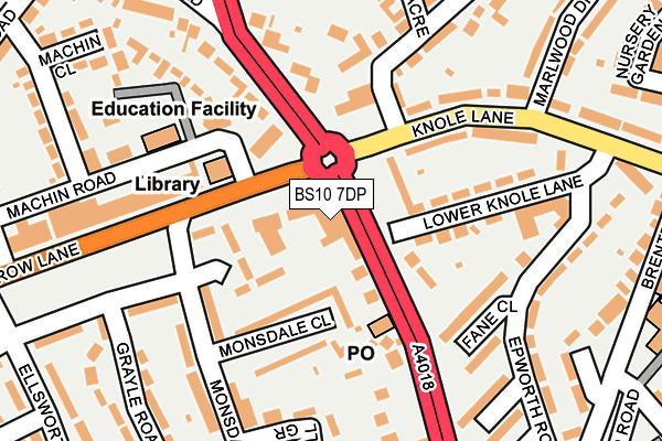
BS10 7DP is located in the Henbury and Brentry electoral ward, within the unitary authority of Bristol, City of and the English Parliamentary constituency of Bristol North West. The Sub Integrated Care Board (ICB) Location is NHS Bristol, North Somerset and South Gloucestershire ICB - 15C and the police force is Avon and Somerset. This postcode has been in use since January 1980.


GetTheData
Source: OS OpenMap – Local (Ordnance Survey)
Source: OS VectorMap District (Ordnance Survey)
Licence: Open Government Licence (requires attribution)
| Easting | 357208 |
| Northing | 179110 |
| Latitude | 51.509287 |
| Longitude | -2.617991 |
GetTheData
Source: Open Postcode Geo
Licence: Open Government Licence
| Country | England |
| Postcode District | BS10 |
➜ See where BS10 is on a map ➜ Where is Bristol? | |
GetTheData
Source: Land Registry Price Paid Data
Licence: Open Government Licence
Elevation or altitude of BS10 7DP as distance above sea level:
| Metres | Feet | |
|---|---|---|
| Elevation | 50m | 164ft |
Elevation is measured from the approximate centre of the postcode, to the nearest point on an OS contour line from OS Terrain 50, which has contour spacing of ten vertical metres.
➜ How high above sea level am I? Find the elevation of your current position using your device's GPS.
GetTheData
Source: Open Postcode Elevation
Licence: Open Government Licence
| Ward | Henbury And Brentry |
| Constituency | Bristol North West |
GetTheData
Source: ONS Postcode Database
Licence: Open Government Licence
| Brentry Roundabout (Crow Lane) | Brentry | 106m |
| Brentry Roundabout (Crow Lane) | Brentry | 119m |
| Marlwood Drive (Knole Lane) | Brentry | 234m |
| Marlwood Drive (Knole Lane) | Brentry | 266m |
| Brentry Lane (Passage Road) | Brentry | 270m |
| Filton Abbey Wood Station | 3.9km |
| Sea Mills Station | 3.9km |
| Patchway Station | 4.3km |
GetTheData
Source: NaPTAN
Licence: Open Government Licence
GetTheData
Source: ONS Postcode Database
Licence: Open Government Licence


➜ Get more ratings from the Food Standards Agency
GetTheData
Source: Food Standards Agency
Licence: FSA terms & conditions
| Last Collection | |||
|---|---|---|---|
| Location | Mon-Fri | Sat | Distance |
| Brentry Post Office | 17:00 | 10:45 | 103m |
| Standfast Road | 16:30 | 10:45 | 317m |
| Brentry Lane | 17:00 | 11:15 | 321m |
GetTheData
Source: Dracos
Licence: Creative Commons Attribution-ShareAlike
The below table lists the International Territorial Level (ITL) codes (formerly Nomenclature of Territorial Units for Statistics (NUTS) codes) and Local Administrative Units (LAU) codes for BS10 7DP:
| ITL 1 Code | Name |
|---|---|
| TLK | South West (England) |
| ITL 2 Code | Name |
| TLK1 | Gloucestershire, Wiltshire and Bath/Bristol area |
| ITL 3 Code | Name |
| TLK11 | Bristol, City of |
| LAU 1 Code | Name |
| E06000023 | Bristol, City of |
GetTheData
Source: ONS Postcode Directory
Licence: Open Government Licence
The below table lists the Census Output Area (OA), Lower Layer Super Output Area (LSOA), and Middle Layer Super Output Area (MSOA) for BS10 7DP:
| Code | Name | |
|---|---|---|
| OA | E00073751 | |
| LSOA | E01014605 | Bristol 001E |
| MSOA | E02003012 | Bristol 001 |
GetTheData
Source: ONS Postcode Directory
Licence: Open Government Licence
| BS10 7DN | Passage Road | 74m |
| BS10 7EA | Monsdale Close | 94m |
| BS10 6SA | Lower Knole Lane | 137m |
| BS10 7DY | Monsdale Drive | 146m |
| BS10 6QE | Fane Close | 151m |
| BS10 6SB | Knole Lane | 154m |
| BS10 6SD | Knole Lane | 159m |
| BS10 7DR | Crow Lane | 173m |
| BS10 7HG | Machin Road | 173m |
| BS10 7EB | Fennell Grove | 173m |
GetTheData
Source: Open Postcode Geo; Land Registry Price Paid Data
Licence: Open Government Licence