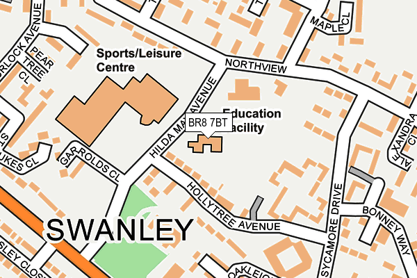
BR8 7BT is located in the Swanley White Oak electoral ward, within the local authority district of Sevenoaks and the English Parliamentary constituency of Sevenoaks. The Sub Integrated Care Board (ICB) Location is NHS Kent and Medway ICB - 91Q and the police force is Kent. This postcode has been in use since January 1980.


GetTheData
Source: OS OpenMap – Local (Ordnance Survey)
Source: OS VectorMap District (Ordnance Survey)
Licence: Open Government Licence (requires attribution)
| Easting | 551164 |
| Northing | 169131 |
| Latitude | 51.401073 |
| Longitude | 0.171717 |
GetTheData
Source: Open Postcode Geo
Licence: Open Government Licence
| Country | England |
| Postcode District | BR8 |
➜ See where BR8 is on a map ➜ Where is Swanley? | |
GetTheData
Source: Land Registry Price Paid Data
Licence: Open Government Licence
Elevation or altitude of BR8 7BT as distance above sea level:
| Metres | Feet | |
|---|---|---|
| Elevation | 70m | 230ft |
Elevation is measured from the approximate centre of the postcode, to the nearest point on an OS contour line from OS Terrain 50, which has contour spacing of ten vertical metres.
➜ How high above sea level am I? Find the elevation of your current position using your device's GPS.
GetTheData
Source: Open Postcode Elevation
Licence: Open Government Licence
| Ward | Swanley White Oak |
| Constituency | Sevenoaks |
GetTheData
Source: ONS Postcode Database
Licence: Open Government Licence
| Garrolds Close (Hilda May Avenue) | Swanley | 153m |
| Northview | Swanley | 169m |
| Garrolds Close (Hilda May Avenue) | Swanley | 189m |
| Northview | Swanley | 191m |
| Bonney Way (Sycamore Drive) | Swanley | 202m |
| Swanley Station | 0.9km |
| Farningham Road Station | 4.4km |
| St Mary Cray Station | 4.6km |
GetTheData
Source: NaPTAN
Licence: Open Government Licence
GetTheData
Source: ONS Postcode Database
Licence: Open Government Licence


➜ Get more ratings from the Food Standards Agency
GetTheData
Source: Food Standards Agency
Licence: FSA terms & conditions
| Last Collection | |||
|---|---|---|---|
| Location | Mon-Fri | Sat | Distance |
| Hollytree Avenue (9) | 18:00 | 11:30 | 167m |
| Northview (100) | 18:00 | 11:30 | 235m |
| White Oaks London Road | 18:00 | 12:00 | 329m |
GetTheData
Source: Dracos
Licence: Creative Commons Attribution-ShareAlike
The below table lists the International Territorial Level (ITL) codes (formerly Nomenclature of Territorial Units for Statistics (NUTS) codes) and Local Administrative Units (LAU) codes for BR8 7BT:
| ITL 1 Code | Name |
|---|---|
| TLJ | South East (England) |
| ITL 2 Code | Name |
| TLJ4 | Kent |
| ITL 3 Code | Name |
| TLJ46 | West Kent |
| LAU 1 Code | Name |
| E07000111 | Sevenoaks |
GetTheData
Source: ONS Postcode Directory
Licence: Open Government Licence
The below table lists the Census Output Area (OA), Lower Layer Super Output Area (LSOA), and Middle Layer Super Output Area (MSOA) for BR8 7BT:
| Code | Name | |
|---|---|---|
| OA | E00124258 | |
| LSOA | E01024480 | Sevenoaks 002D |
| MSOA | E02005088 | Sevenoaks 002 |
GetTheData
Source: ONS Postcode Directory
Licence: Open Government Licence
| BR8 7BB | Holly Tree Avenue | 118m |
| BR8 7BD | Holly Tree Avenue | 136m |
| BR8 7AZ | Sycamore Drive | 149m |
| BR8 7BH | 161m | |
| BR8 7BE | Northview | 168m |
| BR8 7BJ | Northview | 195m |
| BR8 7YT | Sprucedale Close | 196m |
| BR8 7YP | The Oaks | 198m |
| BR8 7WJ | Oakleigh Close | 213m |
| BR8 7YE | Inglewood | 219m |
GetTheData
Source: Open Postcode Geo; Land Registry Price Paid Data
Licence: Open Government Licence