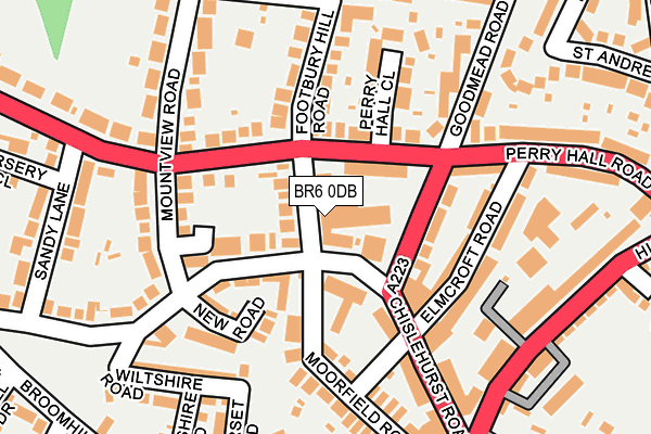
BR6 0DB is located in the St Mary Cray electoral ward, within the London borough of Bromley and the English Parliamentary constituency of Orpington. The Sub Integrated Care Board (ICB) Location is NHS South East London ICB - 72Q and the police force is Metropolitan Police. This postcode has been in use since January 1980.


GetTheData
Source: OS OpenMap – Local (Ordnance Survey)
Source: OS VectorMap District (Ordnance Survey)
Licence: Open Government Licence (requires attribution)
| Easting | 546336 |
| Northing | 166859 |
| Latitude | 51.381923 |
| Longitude | 0.101426 |
GetTheData
Source: Open Postcode Geo
Licence: Open Government Licence
| Country | England |
| Postcode District | BR6 |
➜ See where BR6 is on a map ➜ Where is Orpington? | |
GetTheData
Source: Land Registry Price Paid Data
Licence: Open Government Licence
Elevation or altitude of BR6 0DB as distance above sea level:
| Metres | Feet | |
|---|---|---|
| Elevation | 60m | 197ft |
Elevation is measured from the approximate centre of the postcode, to the nearest point on an OS contour line from OS Terrain 50, which has contour spacing of ten vertical metres.
➜ How high above sea level am I? Find the elevation of your current position using your device's GPS.
GetTheData
Source: Open Postcode Elevation
Licence: Open Government Licence
| Ward | St Mary Cray |
| Constituency | Orpington |
GetTheData
Source: ONS Postcode Database
Licence: Open Government Licence
| Goodmead Road | Broom Hill | 77m |
| Mountview Road (Perry Hall Road) | Broom Hill | 80m |
| Mountview Road (Perry Hall Road) | Broom Hill | 126m |
| Orpington Perry Hall Road (Perry Hall Road) | Derry Downs | 299m |
| High Street Carlton Parade (Orpington High Street) | Derry Downs | 305m |
| Orpington Station | 1.3km |
| St Mary Cray Station | 1.5km |
| Petts Wood Station | 2km |
GetTheData
Source: NaPTAN
Licence: Open Government Licence
GetTheData
Source: ONS Postcode Database
Licence: Open Government Licence


➜ Get more ratings from the Food Standards Agency
GetTheData
Source: Food Standards Agency
Licence: FSA terms & conditions
| Last Collection | |||
|---|---|---|---|
| Location | Mon-Fri | Sat | Distance |
| Chislehurst Road/Footbury Hill | 17:45 | 12:00 | 34m |
| Glendower Crescent (Opp' 1) | 17:45 | 12:00 | 274m |
| Lower High Street (89) | 18:30 | 12:00 | 281m |
GetTheData
Source: Dracos
Licence: Creative Commons Attribution-ShareAlike
The below table lists the International Territorial Level (ITL) codes (formerly Nomenclature of Territorial Units for Statistics (NUTS) codes) and Local Administrative Units (LAU) codes for BR6 0DB:
| ITL 1 Code | Name |
|---|---|
| TLI | London |
| ITL 2 Code | Name |
| TLI6 | Outer London - South |
| ITL 3 Code | Name |
| TLI61 | Bromley |
| LAU 1 Code | Name |
| E09000006 | Bromley |
GetTheData
Source: ONS Postcode Directory
Licence: Open Government Licence
The below table lists the Census Output Area (OA), Lower Layer Super Output Area (LSOA), and Middle Layer Super Output Area (MSOA) for BR6 0DB:
| Code | Name | |
|---|---|---|
| OA | E00003500 | |
| LSOA | E01000727 | Bromley 028A |
| MSOA | E02000154 | Bromley 028 |
GetTheData
Source: ONS Postcode Directory
Licence: Open Government Licence
| BR6 0HR | Perry Hall Road | 53m |
| BR6 0DQ | Chislehurst Road | 88m |
| BR6 0DJ | Chislehurst Road | 118m |
| BR6 0HP | Footbury Hill Road | 122m |
| BR6 0HX | Goodmead Road | 124m |
| BR6 0DX | New Road | 126m |
| BR6 0HY | Elmcroft Road | 129m |
| BR6 0JL | Deakins Terrace | 131m |
| BR6 0DG | Chislehurst Road | 139m |
| BR6 0DF | Chislehurst Road | 145m |
GetTheData
Source: Open Postcode Geo; Land Registry Price Paid Data
Licence: Open Government Licence