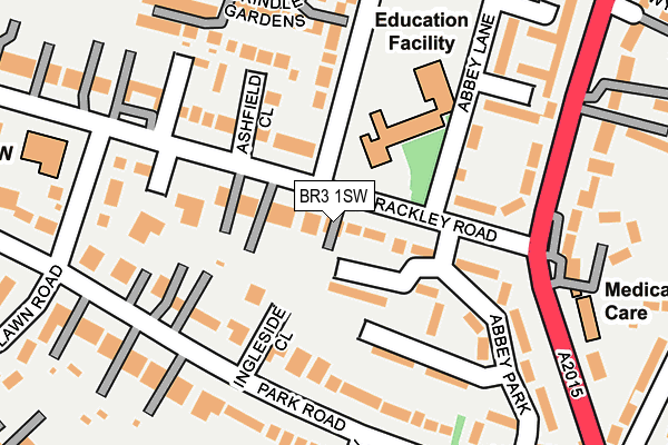
BR3 1SW lies on Brackley Road in Beckenham. BR3 1SW is located in the Beckenham Town & Copers Cope electoral ward, within the London borough of Bromley and the English Parliamentary constituency of Beckenham. The Sub Integrated Care Board (ICB) Location is NHS South East London ICB - 72Q and the police force is Metropolitan Police. This postcode has been in use since December 1994.


GetTheData
Source: OS OpenMap – Local (Ordnance Survey)
Source: OS VectorMap District (Ordnance Survey)
Licence: Open Government Licence (requires attribution)
| Easting | 537256 |
| Northing | 170341 |
| Latitude | 51.415479 |
| Longitude | -0.027620 |
GetTheData
Source: Open Postcode Geo
Licence: Open Government Licence
| Street | Brackley Road |
| Town/City | Beckenham |
| Country | England |
| Postcode District | BR3 |
➜ See where BR3 is on a map ➜ Where is Beckenham? | |
GetTheData
Source: Land Registry Price Paid Data
Licence: Open Government Licence
Elevation or altitude of BR3 1SW as distance above sea level:
| Metres | Feet | |
|---|---|---|
| Elevation | 40m | 131ft |
Elevation is measured from the approximate centre of the postcode, to the nearest point on an OS contour line from OS Terrain 50, which has contour spacing of ten vertical metres.
➜ How high above sea level am I? Find the elevation of your current position using your device's GPS.
GetTheData
Source: Open Postcode Elevation
Licence: Open Government Licence
| Ward | Beckenham Town & Copers Cope |
| Constituency | Beckenham |
GetTheData
Source: ONS Postcode Database
Licence: Open Government Licence
| Silverwood Close (Brackley Road) | New Beckenham | 119m |
| Worsley Bridge Rdbrackley Rd (Worsley Bridge Road) | New Beckenham | 142m |
| Silverwood Close (Brackley Road) | New Beckenham | 145m |
| Worsley Bridge Rdbrackley Rd (Worsley Bridge Road) | New Beckenham | 160m |
| Brackley Road | New Beckenham | 211m |
| Beckenham Junction Tram Stop (Rectory Road) | Beckenham | 535m |
| Beckenham Road Tram Stop (Beckenham Road) | Penge & Sydenham | 1,283m |
| Avenue Road Tram Stop (Avenue Road) | Penge & Sydenham | 1,801m |
| Beckenham Junction Station | 0.5km |
| New Beckenham Station | 0.6km |
| Lower Sydenham Station | 1.1km |
GetTheData
Source: NaPTAN
Licence: Open Government Licence
| Percentage of properties with Next Generation Access | 100.0% |
| Percentage of properties with Superfast Broadband | 100.0% |
| Percentage of properties with Ultrafast Broadband | 0.0% |
| Percentage of properties with Full Fibre Broadband | 0.0% |
Superfast Broadband is between 30Mbps and 300Mbps
Ultrafast Broadband is > 300Mbps
| Median download speed | 23.2Mbps |
| Average download speed | 24.9Mbps |
| Maximum download speed | 44.00Mbps |
| Median upload speed | 1.6Mbps |
| Average upload speed | 3.8Mbps |
| Maximum upload speed | 9.38Mbps |
| Percentage of properties unable to receive 2Mbps | 0.0% |
| Percentage of properties unable to receive 5Mbps | 0.0% |
| Percentage of properties unable to receive 10Mbps | 0.0% |
| Percentage of properties unable to receive 30Mbps | 0.0% |
GetTheData
Source: Ofcom
Licence: Ofcom Terms of Use (requires attribution)
Estimated total energy consumption in BR3 1SW by fuel type, 2015.
| Consumption (kWh) | 94,412 |
|---|---|
| Meter count | 15 |
| Mean (kWh/meter) | 6,294 |
| Median (kWh/meter) | 5,540 |
GetTheData
Source: Postcode level gas estimates: 2015 (experimental)
Source: Postcode level electricity estimates: 2015 (experimental)
Licence: Open Government Licence
GetTheData
Source: ONS Postcode Database
Licence: Open Government Licence


➜ Get more ratings from the Food Standards Agency
GetTheData
Source: Food Standards Agency
Licence: FSA terms & conditions
| Last Collection | |||
|---|---|---|---|
| Location | Mon-Fri | Sat | Distance |
| Park Road (42) | 18:15 | 12:00 | 165m |
| Brackley Road (Edden House) | 18:00 | 12:00 | 177m |
| Faircroft | 18:15 | 12:00 | 385m |
GetTheData
Source: Dracos
Licence: Creative Commons Attribution-ShareAlike
The below table lists the International Territorial Level (ITL) codes (formerly Nomenclature of Territorial Units for Statistics (NUTS) codes) and Local Administrative Units (LAU) codes for BR3 1SW:
| ITL 1 Code | Name |
|---|---|
| TLI | London |
| ITL 2 Code | Name |
| TLI6 | Outer London - South |
| ITL 3 Code | Name |
| TLI61 | Bromley |
| LAU 1 Code | Name |
| E09000006 | Bromley |
GetTheData
Source: ONS Postcode Directory
Licence: Open Government Licence
The below table lists the Census Output Area (OA), Lower Layer Super Output Area (LSOA), and Middle Layer Super Output Area (MSOA) for BR3 1SW:
| Code | Name | |
|---|---|---|
| OA | E00003434 | |
| LSOA | E01000710 | Bromley 006B |
| MSOA | E02000132 | Bromley 006 |
GetTheData
Source: ONS Postcode Directory
Licence: Open Government Licence
| BR3 1RX | Brackley Road | 54m |
| BR3 1UA | Brackley Road | 76m |
| BR3 1RB | Brackley Road | 78m |
| BR3 1QE | Abbey Park | 91m |
| BR3 1PT | Abbey Park | 110m |
| BR3 1RE | Brackley Road | 112m |
| BR3 1PW | Abbey Park | 123m |
| BR3 1PR | Abbey Park | 126m |
| BR3 1QB | Abbey Park | 126m |
| BR3 1SN | Ashfield Close | 127m |
GetTheData
Source: Open Postcode Geo; Land Registry Price Paid Data
Licence: Open Government Licence