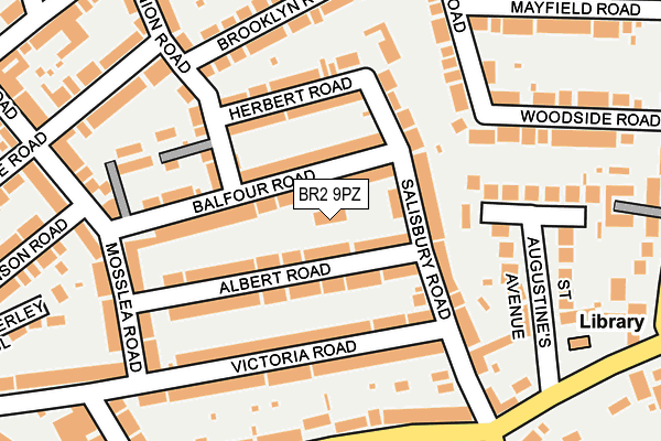
BR2 9PZ is located in the Bromley Common & Holwood electoral ward, within the London borough of Bromley and the English Parliamentary constituency of Beckenham. The Sub Integrated Care Board (ICB) Location is NHS South East London ICB - 72Q and the police force is Metropolitan Police. This postcode has been in use since September 2016.


GetTheData
Source: OS OpenMap – Local (Ordnance Survey)
Source: OS VectorMap District (Ordnance Survey)
Licence: Open Government Licence (requires attribution)
| Easting | 542051 |
| Northing | 167743 |
| Latitude | 51.390954 |
| Longitude | 0.040273 |
GetTheData
Source: Open Postcode Geo
Licence: Open Government Licence
| Country | England |
| Postcode District | BR2 |
➜ See where BR2 is on a map ➜ Where is London? | |
GetTheData
Source: Land Registry Price Paid Data
Licence: Open Government Licence
Elevation or altitude of BR2 9PZ as distance above sea level:
| Metres | Feet | |
|---|---|---|
| Elevation | 60m | 197ft |
Elevation is measured from the approximate centre of the postcode, to the nearest point on an OS contour line from OS Terrain 50, which has contour spacing of ten vertical metres.
➜ How high above sea level am I? Find the elevation of your current position using your device's GPS.
GetTheData
Source: Open Postcode Elevation
Licence: Open Government Licence
| Ward | Bromley Common & Holwood |
| Constituency | Beckenham |
GetTheData
Source: ONS Postcode Database
Licence: Open Government Licence
| Southborough Library | Southborough | 259m |
| Southborough Library (Southborough Lane) | Southborough | 267m |
| Newton Terrace (Crown Lane) | Southborough | 282m |
| Woodside Rd Southborough Rd | Southborough | 328m |
| Crown Lane Spur | Southborough | 339m |
| Bickley Station | 1.1km |
| Bromley South Station | 1.9km |
| Chislehurst Station | 2km |
GetTheData
Source: NaPTAN
Licence: Open Government Licence
GetTheData
Source: ONS Postcode Database
Licence: Open Government Licence


➜ Get more ratings from the Food Standards Agency
GetTheData
Source: Food Standards Agency
Licence: FSA terms & conditions
| Last Collection | |||
|---|---|---|---|
| Location | Mon-Fri | Sat | Distance |
| Salisbury Road (18) | 18:30 | 12:00 | 148m |
| Chatterton Road (40) | 18:30 | 12:00 | 340m |
| Southands Road (133) | 18:30 | 12:00 | 554m |
GetTheData
Source: Dracos
Licence: Creative Commons Attribution-ShareAlike
The below table lists the International Territorial Level (ITL) codes (formerly Nomenclature of Territorial Units for Statistics (NUTS) codes) and Local Administrative Units (LAU) codes for BR2 9PZ:
| ITL 1 Code | Name |
|---|---|
| TLI | London |
| ITL 2 Code | Name |
| TLI6 | Outer London - South |
| ITL 3 Code | Name |
| TLI61 | Bromley |
| LAU 1 Code | Name |
| E09000006 | Bromley |
GetTheData
Source: ONS Postcode Directory
Licence: Open Government Licence
The below table lists the Census Output Area (OA), Lower Layer Super Output Area (LSOA), and Middle Layer Super Output Area (MSOA) for BR2 9PZ:
| Code | Name | |
|---|---|---|
| OA | E00003192 | |
| LSOA | E01000669 | Bromley 020C |
| MSOA | E02000146 | Bromley 020 |
GetTheData
Source: ONS Postcode Directory
Licence: Open Government Licence
| BR2 9PT | Albert Road | 52m |
| BR2 9SL | Balfour Road | 54m |
| BR2 9PN | Salisbury Road | 62m |
| BR2 9SJ | Balfour Road | 66m |
| BR2 9PY | Albert Road | 67m |
| BR2 9PU | Salisbury Road | 89m |
| BR2 9SH | Herbert Road | 108m |
| BR2 9PL | Victoria Road | 123m |
| BR2 9PR | Victoria Road | 131m |
| BR2 9PP | Victoria Road | 145m |
GetTheData
Source: Open Postcode Geo; Land Registry Price Paid Data
Licence: Open Government Licence