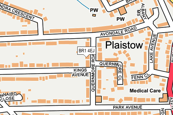
BR1 4EJ lies on Quernmore Road in Bromley. BR1 4EJ is located in the Plaistow electoral ward, within the London borough of Bromley and the English Parliamentary constituency of Bromley and Chislehurst. The Sub Integrated Care Board (ICB) Location is NHS South East London ICB - 72Q and the police force is Metropolitan Police. This postcode has been in use since January 1980.


GetTheData
Source: OS OpenMap – Local (Ordnance Survey)
Source: OS VectorMap District (Ordnance Survey)
Licence: Open Government Licence (requires attribution)
| Easting | 540062 |
| Northing | 170740 |
| Latitude | 51.418379 |
| Longitude | 0.012862 |
GetTheData
Source: Open Postcode Geo
Licence: Open Government Licence
| Street | Quernmore Road |
| Town/City | Bromley |
| Country | England |
| Postcode District | BR1 |
➜ See where BR1 is on a map ➜ Where is London? | |
GetTheData
Source: Land Registry Price Paid Data
Licence: Open Government Licence
Elevation or altitude of BR1 4EJ as distance above sea level:
| Metres | Feet | |
|---|---|---|
| Elevation | 50m | 164ft |
Elevation is measured from the approximate centre of the postcode, to the nearest point on an OS contour line from OS Terrain 50, which has contour spacing of ten vertical metres.
➜ How high above sea level am I? Find the elevation of your current position using your device's GPS.
GetTheData
Source: Open Postcode Elevation
Licence: Open Government Licence
| Ward | Plaistow |
| Constituency | Bromley And Chislehurst |
GetTheData
Source: ONS Postcode Database
Licence: Open Government Licence
| Burnt Ash Primary School (Rangefield Road) | Plaistow | 251m |
| Rangefield Road Southover | Plaistow | 298m |
| Park Avenue (Br1) (Burnt Ash Lane) | Plaistow | 299m |
| Rangefield Road Southover (Rangefield Road) | Plaistow | 313m |
| Park Avenue (Br1) (Burnt Ash Lane) | Plaistow | 328m |
| Sundridge Park Station | 0.8km |
| Bromley North Station | 1.2km |
| Ravensbourne Station | 1.5km |
GetTheData
Source: NaPTAN
Licence: Open Government Licence
| Percentage of properties with Next Generation Access | 100.0% |
| Percentage of properties with Superfast Broadband | 100.0% |
| Percentage of properties with Ultrafast Broadband | 100.0% |
| Percentage of properties with Full Fibre Broadband | 0.0% |
Superfast Broadband is between 30Mbps and 300Mbps
Ultrafast Broadband is > 300Mbps
| Percentage of properties unable to receive 2Mbps | 0.0% |
| Percentage of properties unable to receive 5Mbps | 0.0% |
| Percentage of properties unable to receive 10Mbps | 0.0% |
| Percentage of properties unable to receive 30Mbps | 0.0% |
GetTheData
Source: Ofcom
Licence: Ofcom Terms of Use (requires attribution)
GetTheData
Source: ONS Postcode Database
Licence: Open Government Licence


➜ Get more ratings from the Food Standards Agency
GetTheData
Source: Food Standards Agency
Licence: FSA terms & conditions
| Last Collection | |||
|---|---|---|---|
| Location | Mon-Fri | Sat | Distance |
| Park Avenue (47) | 18:30 | 12:00 | 164m |
| Avondale Crescent (66) | 18:30 | 12:00 | 192m |
| Kings Avenue (39) | 18:30 | 12:00 | 383m |
GetTheData
Source: Dracos
Licence: Creative Commons Attribution-ShareAlike
The below table lists the International Territorial Level (ITL) codes (formerly Nomenclature of Territorial Units for Statistics (NUTS) codes) and Local Administrative Units (LAU) codes for BR1 4EJ:
| ITL 1 Code | Name |
|---|---|
| TLI | London |
| ITL 2 Code | Name |
| TLI6 | Outer London - South |
| ITL 3 Code | Name |
| TLI61 | Bromley |
| LAU 1 Code | Name |
| E09000006 | Bromley |
GetTheData
Source: ONS Postcode Directory
Licence: Open Government Licence
The below table lists the Census Output Area (OA), Lower Layer Super Output Area (LSOA), and Middle Layer Super Output Area (MSOA) for BR1 4EJ:
| Code | Name | |
|---|---|---|
| OA | E00003995 | |
| LSOA | E01032563 | Bromley 040E |
| MSOA | E02006782 | Bromley 040 |
GetTheData
Source: ONS Postcode Directory
Licence: Open Government Licence
| BR1 4EH | Quernmore Road | 26m |
| BR1 4EL | Quernmore Close | 109m |
| BR1 4EP | Avondale Road | 137m |
| BR1 4EG | Park Avenue | 150m |
| BR1 4HT | Avondale Road | 150m |
| BR1 4HP | Kings Avenue | 156m |
| BR1 4DX | Fenn Close | 198m |
| BR1 4EE | Park Avenue | 199m |
| BR1 4HN | Kings Avenue | 202m |
| BR1 4HW | Kings Avenue | 216m |
GetTheData
Source: Open Postcode Geo; Land Registry Price Paid Data
Licence: Open Government Licence