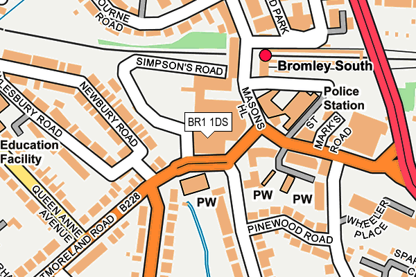
BR1 1DS is located in the Bromley Town electoral ward, within the London borough of Bromley and the English Parliamentary constituency of Bromley and Chislehurst. The Sub Integrated Care Board (ICB) Location is NHS South East London ICB - 72Q and the police force is Metropolitan Police. This postcode has been in use since January 1980.


GetTheData
Source: OS OpenMap – Local (Ordnance Survey)
Source: OS VectorMap District (Ordnance Survey)
Licence: Open Government Licence (requires attribution)
| Easting | 540356 |
| Northing | 168677 |
| Latitude | 51.399768 |
| Longitude | 0.016297 |
GetTheData
Source: Open Postcode Geo
Licence: Open Government Licence
| Country | England |
| Postcode District | BR1 |
➜ See where BR1 is on a map ➜ Where is Bromley? | |
GetTheData
Source: Land Registry Price Paid Data
Licence: Open Government Licence
Elevation or altitude of BR1 1DS as distance above sea level:
| Metres | Feet | |
|---|---|---|
| Elevation | 50m | 164ft |
Elevation is measured from the approximate centre of the postcode, to the nearest point on an OS contour line from OS Terrain 50, which has contour spacing of ten vertical metres.
➜ How high above sea level am I? Find the elevation of your current position using your device's GPS.
GetTheData
Source: Open Postcode Elevation
Licence: Open Government Licence
| Ward | Bromley Town |
| Constituency | Bromley And Chislehurst |
GetTheData
Source: ONS Postcode Database
Licence: Open Government Licence
| Bromley South Station (Bromley High Street) | Bromley | 73m |
| St Mark's Church (Westmoreland Road) | Bromley | 93m |
| Bromley South Station (Bromley High Street) | Bromley | 100m |
| Bromley South Station (Bromley High Street) | Bromley | 102m |
| St Mark's Church | Bromley | 114m |
| Bromley South Station | 0.1km |
| Bromley North Station | 1km |
| Shortlands Station | 1.2km |
GetTheData
Source: NaPTAN
Licence: Open Government Licence
GetTheData
Source: ONS Postcode Database
Licence: Open Government Licence


➜ Get more ratings from the Food Standards Agency
GetTheData
Source: Food Standards Agency
Licence: FSA terms & conditions
| Last Collection | |||
|---|---|---|---|
| Location | Mon-Fri | Sat | Distance |
| Westmorland Place | 18:30 | 12:00 | 69m |
| Bromley South Station | 18:30 | 12:00 | 89m |
| Elmfield Road (28) | 186m | ||
GetTheData
Source: Dracos
Licence: Creative Commons Attribution-ShareAlike
The below table lists the International Territorial Level (ITL) codes (formerly Nomenclature of Territorial Units for Statistics (NUTS) codes) and Local Administrative Units (LAU) codes for BR1 1DS:
| ITL 1 Code | Name |
|---|---|
| TLI | London |
| ITL 2 Code | Name |
| TLI6 | Outer London - South |
| ITL 3 Code | Name |
| TLI61 | Bromley |
| LAU 1 Code | Name |
| E09000006 | Bromley |
GetTheData
Source: ONS Postcode Directory
Licence: Open Government Licence
The below table lists the Census Output Area (OA), Lower Layer Super Output Area (LSOA), and Middle Layer Super Output Area (MSOA) for BR1 1DS:
| Code | Name | |
|---|---|---|
| OA | E00003264 | |
| LSOA | E01000675 | Bromley 018B |
| MSOA | E02000144 | Bromley 018 |
GetTheData
Source: ONS Postcode Directory
Licence: Open Government Licence
| BR1 1EA | High Street | 83m |
| BR1 1HN | Ravensbourne Road | 103m |
| BR1 1LG | High Street | 139m |
| BR2 0TB | Westmoreland Road | 146m |
| BR2 9HD | Masons Hill | 156m |
| BR2 9GP | Sandford Road | 164m |
| BR2 0QW | Newbury Road | 171m |
| BR1 1HP | Ravensbourne Road | 172m |
| BR1 1LA | High Street | 185m |
| BR2 0QN | Newbury Road | 193m |
GetTheData
Source: Open Postcode Geo; Land Registry Price Paid Data
Licence: Open Government Licence