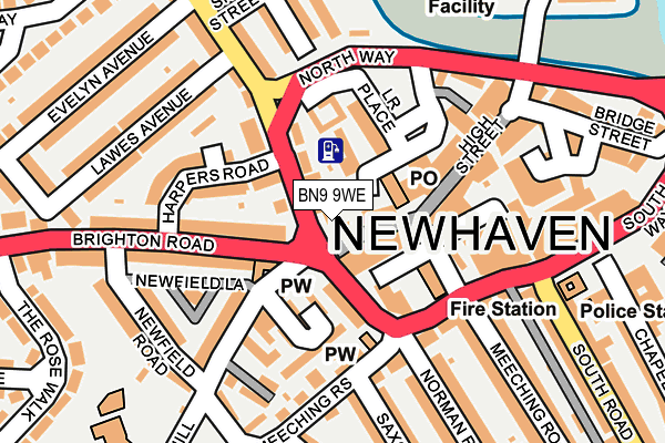
BN9 9WE is located in the Newhaven South electoral ward, within the local authority district of Lewes and the English Parliamentary constituency of Lewes. The Sub Integrated Care Board (ICB) Location is NHS Sussex ICB - 97R and the police force is Sussex. This postcode has been in use since June 2003.


GetTheData
Source: OS OpenMap – Local (Ordnance Survey)
Source: OS VectorMap District (Ordnance Survey)
Licence: Open Government Licence (requires attribution)
| Easting | 544382 |
| Northing | 101360 |
| Latitude | 50.793830 |
| Longitude | 0.047210 |
GetTheData
Source: Open Postcode Geo
Licence: Open Government Licence
| Country | England |
| Postcode District | BN9 |
➜ See where BN9 is on a map ➜ Where is Newhaven? | |
GetTheData
Source: Land Registry Price Paid Data
Licence: Open Government Licence
Elevation or altitude of BN9 9WE as distance above sea level:
| Metres | Feet | |
|---|---|---|
| Elevation | 20m | 66ft |
Elevation is measured from the approximate centre of the postcode, to the nearest point on an OS contour line from OS Terrain 50, which has contour spacing of ten vertical metres.
➜ How high above sea level am I? Find the elevation of your current position using your device's GPS.
GetTheData
Source: Open Postcode Elevation
Licence: Open Government Licence
| Ward | Newhaven South |
| Constituency | Lewes |
GetTheData
Source: ONS Postcode Database
Licence: Open Government Licence
| Elim Church (South Way) | Newhaven | 104m |
| Lower Place | Newhaven | 129m |
| Evelyn Avenue (Lewes Road) | Newhaven | 222m |
| South Road | Newhaven | 251m |
| Evelyn Avenue (Lewes Road) | Newhaven | 252m |
| Newhaven Town Station | 0.6km |
| Newhaven Harbour Station | 0.7km |
| Bishopstone Station | 2.9km |
GetTheData
Source: NaPTAN
Licence: Open Government Licence
GetTheData
Source: ONS Postcode Database
Licence: Open Government Licence


➜ Get more ratings from the Food Standards Agency
GetTheData
Source: Food Standards Agency
Licence: FSA terms & conditions
| Last Collection | |||
|---|---|---|---|
| Location | Mon-Fri | Sat | Distance |
| Royal Mail High Street | 18:15 | 12:30 | 24m |
| Newhaven Post Office | 17:30 | 12:30 | 162m |
| South Way | 17:15 | 12:00 | 280m |
GetTheData
Source: Dracos
Licence: Creative Commons Attribution-ShareAlike
The below table lists the International Territorial Level (ITL) codes (formerly Nomenclature of Territorial Units for Statistics (NUTS) codes) and Local Administrative Units (LAU) codes for BN9 9WE:
| ITL 1 Code | Name |
|---|---|
| TLJ | South East (England) |
| ITL 2 Code | Name |
| TLJ2 | Surrey, East and West Sussex |
| ITL 3 Code | Name |
| TLJ22 | East Sussex CC |
| LAU 1 Code | Name |
| E07000063 | Lewes |
GetTheData
Source: ONS Postcode Directory
Licence: Open Government Licence
The below table lists the Census Output Area (OA), Lower Layer Super Output Area (LSOA), and Middle Layer Super Output Area (MSOA) for BN9 9WE:
| Code | Name | |
|---|---|---|
| OA | E00106916 | |
| LSOA | E01021049 | Lewes 009B |
| MSOA | E02004387 | Lewes 009 |
GetTheData
Source: ONS Postcode Directory
Licence: Open Government Licence
| BN9 9RP | Lewes Road | 46m |
| BN9 9PA | High Street | 49m |
| BN9 9BF | North Lane | 64m |
| BN9 9LL | South Way | 76m |
| BN9 9LN | Church Hill | 79m |
| BN9 9RB | Marshall Lane | 88m |
| BN9 9BJ | Essex Mews | 90m |
| BN9 9LW | Cloisters | 99m |
| BN9 9QX | Meeching Road | 101m |
| BN9 9NB | Brighton Road | 102m |
GetTheData
Source: Open Postcode Geo; Land Registry Price Paid Data
Licence: Open Government Licence