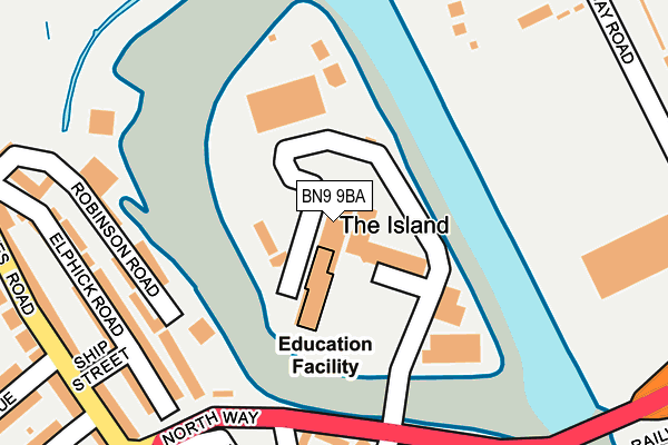
BN9 9BA is located in the Newhaven North electoral ward, within the local authority district of Lewes and the English Parliamentary constituency of Lewes. The Sub Integrated Care Board (ICB) Location is NHS Sussex ICB - 97R and the police force is Sussex. This postcode has been in use since January 1980.


GetTheData
Source: OS OpenMap – Local (Ordnance Survey)
Source: OS VectorMap District (Ordnance Survey)
Licence: Open Government Licence (requires attribution)
| Easting | 544537 |
| Northing | 101689 |
| Latitude | 50.796743 |
| Longitude | 0.049565 |
GetTheData
Source: Open Postcode Geo
Licence: Open Government Licence
| Country | England |
| Postcode District | BN9 |
➜ See where BN9 is on a map ➜ Where is Newhaven? | |
GetTheData
Source: Land Registry Price Paid Data
Licence: Open Government Licence
Elevation or altitude of BN9 9BA as distance above sea level:
| Metres | Feet | |
|---|---|---|
| Elevation | 10m | 33ft |
Elevation is measured from the approximate centre of the postcode, to the nearest point on an OS contour line from OS Terrain 50, which has contour spacing of ten vertical metres.
➜ How high above sea level am I? Find the elevation of your current position using your device's GPS.
GetTheData
Source: Open Postcode Elevation
Licence: Open Government Licence
| Ward | Newhaven North |
| Constituency | Lewes |
GetTheData
Source: ONS Postcode Database
Licence: Open Government Licence
| Lower Place | Newhaven | 257m |
| Evelyn Avenue (Lewes Road) | Newhaven | 300m |
| Evelyn Avenue (Lewes Road) | Newhaven | 312m |
| South Way | Newhaven | 347m |
| Railway Station Interchange (Drove Road) | Newhaven | 383m |
| Newhaven Town Station | 0.4km |
| Newhaven Harbour Station | 0.9km |
| Bishopstone Station | 3km |
GetTheData
Source: NaPTAN
Licence: Open Government Licence
| Median download speed | 38.8Mbps |
| Average download speed | 35.2Mbps |
| Maximum download speed | 50.51Mbps |
| Median upload speed | 4.8Mbps |
| Average upload speed | 5.4Mbps |
| Maximum upload speed | 16.47Mbps |
GetTheData
Source: Ofcom
Licence: Ofcom Terms of Use (requires attribution)
GetTheData
Source: ONS Postcode Database
Licence: Open Government Licence

➜ Get more ratings from the Food Standards Agency
GetTheData
Source: Food Standards Agency
Licence: FSA terms & conditions
| Last Collection | |||
|---|---|---|---|
| Location | Mon-Fri | Sat | Distance |
| Newhaven Post Office | 17:30 | 12:30 | 302m |
| Royal Mail High Street | 18:15 | 12:30 | 355m |
| South Way | 17:15 | 12:00 | 358m |
GetTheData
Source: Dracos
Licence: Creative Commons Attribution-ShareAlike
The below table lists the International Territorial Level (ITL) codes (formerly Nomenclature of Territorial Units for Statistics (NUTS) codes) and Local Administrative Units (LAU) codes for BN9 9BA:
| ITL 1 Code | Name |
|---|---|
| TLJ | South East (England) |
| ITL 2 Code | Name |
| TLJ2 | Surrey, East and West Sussex |
| ITL 3 Code | Name |
| TLJ22 | East Sussex CC |
| LAU 1 Code | Name |
| E07000063 | Lewes |
GetTheData
Source: ONS Postcode Directory
Licence: Open Government Licence
The below table lists the Census Output Area (OA), Lower Layer Super Output Area (LSOA), and Middle Layer Super Output Area (MSOA) for BN9 9BA:
| Code | Name | |
|---|---|---|
| OA | E00106912 | |
| LSOA | E01021051 | Lewes 009D |
| MSOA | E02004387 | Lewes 009 |
GetTheData
Source: ONS Postcode Directory
Licence: Open Government Licence
| BN9 9DT | Butchers Lane | 202m |
| BN9 9BG | Riverside | 202m |
| BN9 9SZ | Elphick Road | 236m |
| BN9 9PE | High Street | 236m |
| BN9 9PJ | Bridge Street | 244m |
| BN9 9PR | High Street | 253m |
| BN9 9PN | Chapel Street | 266m |
| BN9 9SY | Elphick Road | 267m |
| BN9 9PH | Bridge Street | 269m |
| BN9 9TA | Ship Street | 274m |
GetTheData
Source: Open Postcode Geo; Land Registry Price Paid Data
Licence: Open Government Licence