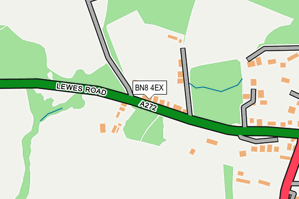
BN8 4EX lies on Haywards Heath Road in North Chailey, Lewes. BN8 4EX is located in the Chailey, Barcombe & Hamsey electoral ward, within the local authority district of Lewes and the English Parliamentary constituency of Lewes. The Sub Integrated Care Board (ICB) Location is NHS Sussex ICB - 97R and the police force is Sussex. This postcode has been in use since January 1980.


GetTheData
Source: OS OpenMap – Local (Ordnance Survey)
Source: OS VectorMap District (Ordnance Survey)
Licence: Open Government Licence (requires attribution)
| Easting | 538865 |
| Northing | 121137 |
| Latitude | 50.972915 |
| Longitude | -0.023511 |
GetTheData
Source: Open Postcode Geo
Licence: Open Government Licence
| Street | Haywards Heath Road |
| Locality | North Chailey |
| Town/City | Lewes |
| Country | England |
| Postcode District | BN8 |
➜ See where BN8 is on a map ➜ Where is North Chailey? | |
GetTheData
Source: Land Registry Price Paid Data
Licence: Open Government Licence
Elevation or altitude of BN8 4EX as distance above sea level:
| Metres | Feet | |
|---|---|---|
| Elevation | 60m | 197ft |
Elevation is measured from the approximate centre of the postcode, to the nearest point on an OS contour line from OS Terrain 50, which has contour spacing of ten vertical metres.
➜ How high above sea level am I? Find the elevation of your current position using your device's GPS.
GetTheData
Source: Open Postcode Elevation
Licence: Open Government Licence
| Ward | Chailey, Barcombe & Hamsey |
| Constituency | Lewes |
GetTheData
Source: ONS Postcode Database
Licence: Open Government Licence
2016 26 MAR £305,000 |
2007 22 MAR £105,000 |
GetTheData
Source: HM Land Registry Price Paid Data
Licence: Contains HM Land Registry data © Crown copyright and database right 2025. This data is licensed under the Open Government Licence v3.0.
| Kings Head (Station Road) | North Chailey | 254m |
| Kings Head (Station Road) | North Chailey | 279m |
| Kings Head (Lewes Road) | North Chailey | 310m |
| Kings Head (Lewes Road) | North Chailey | 326m |
| Chailey Heritage (A272) | North Chailey | 505m |
| Plumpton Station | 5.6km |
GetTheData
Source: NaPTAN
Licence: Open Government Licence
| Percentage of properties with Next Generation Access | 100.0% |
| Percentage of properties with Superfast Broadband | 100.0% |
| Percentage of properties with Ultrafast Broadband | 0.0% |
| Percentage of properties with Full Fibre Broadband | 0.0% |
Superfast Broadband is between 30Mbps and 300Mbps
Ultrafast Broadband is > 300Mbps
| Median download speed | 45.9Mbps |
| Average download speed | 51.1Mbps |
| Maximum download speed | 78.12Mbps |
| Median upload speed | 10.0Mbps |
| Average upload speed | 12.4Mbps |
| Maximum upload speed | 19.53Mbps |
| Percentage of properties unable to receive 2Mbps | 0.0% |
| Percentage of properties unable to receive 5Mbps | 0.0% |
| Percentage of properties unable to receive 10Mbps | 0.0% |
| Percentage of properties unable to receive 30Mbps | 0.0% |
GetTheData
Source: Ofcom
Licence: Ofcom Terms of Use (requires attribution)
Estimated total energy consumption in BN8 4EX by fuel type, 2015.
| Consumption (kWh) | 115,949 |
|---|---|
| Meter count | 8 |
| Mean (kWh/meter) | 14,494 |
| Median (kWh/meter) | 15,261 |
| Consumption (kWh) | 16,824 |
|---|---|
| Meter count | 6 |
| Mean (kWh/meter) | 2,804 |
| Median (kWh/meter) | 2,677 |
GetTheData
Source: Postcode level gas estimates: 2015 (experimental)
Source: Postcode level electricity estimates: 2015 (experimental)
Licence: Open Government Licence
GetTheData
Source: ONS Postcode Database
Licence: Open Government Licence


➜ Get more ratings from the Food Standards Agency
GetTheData
Source: Food Standards Agency
Licence: FSA terms & conditions
| Last Collection | |||
|---|---|---|---|
| Location | Mon-Fri | Sat | Distance |
| The Warren | 16:00 | 08:30 | 797m |
| Newick Station | 16:30 | 09:30 | 1,360m |
| Pellingbridge | 1,705m | ||
GetTheData
Source: Dracos
Licence: Creative Commons Attribution-ShareAlike
The below table lists the International Territorial Level (ITL) codes (formerly Nomenclature of Territorial Units for Statistics (NUTS) codes) and Local Administrative Units (LAU) codes for BN8 4EX:
| ITL 1 Code | Name |
|---|---|
| TLJ | South East (England) |
| ITL 2 Code | Name |
| TLJ2 | Surrey, East and West Sussex |
| ITL 3 Code | Name |
| TLJ22 | East Sussex CC |
| LAU 1 Code | Name |
| E07000063 | Lewes |
GetTheData
Source: ONS Postcode Directory
Licence: Open Government Licence
The below table lists the Census Output Area (OA), Lower Layer Super Output Area (LSOA), and Middle Layer Super Output Area (MSOA) for BN8 4EX:
| Code | Name | |
|---|---|---|
| OA | E00106770 | |
| LSOA | E01021025 | Lewes 001C |
| MSOA | E02004379 | Lewes 001 |
GetTheData
Source: ONS Postcode Directory
Licence: Open Government Licence
| BN8 4EY | Haywards Heath Road | 54m |
| BN8 4EU | Haywards Heath Road | 57m |
| BN8 4EZ | Haywards Heath Road | 83m |
| BN8 4ET | Haywards Heath Road | 225m |
| BN8 4ES | Haywards Heath Road | 285m |
| BN8 4EG | Mill Lane | 311m |
| BN8 4HX | East Grinstead Road | 339m |
| BN8 4DH | East Grinstead Road | 360m |
| BN8 4HA | Downs View Close | 400m |
| BN8 4HB | Downs View | 462m |
GetTheData
Source: Open Postcode Geo; Land Registry Price Paid Data
Licence: Open Government Licence