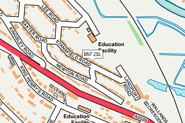
BN7 2SL lies on Stansfield Road in Lewes. BN7 2SL is located in the Lewes Castle electoral ward, within the local authority district of Lewes and the English Parliamentary constituency of Lewes. The Sub Integrated Care Board (ICB) Location is NHS Sussex ICB - 97R and the police force is Sussex. This postcode has been in use since January 1980.


GetTheData
Source: OS OpenMap – Local (Ordnance Survey)
Source: OS VectorMap District (Ordnance Survey)
Licence: Open Government Licence (requires attribution)
| Easting | 540993 |
| Northing | 110650 |
| Latitude | 50.878153 |
| Longitude | 0.002727 |
GetTheData
Source: Open Postcode Geo
Licence: Open Government Licence
| Street | Stansfield Road |
| Town/City | Lewes |
| Country | England |
| Postcode District | BN7 |
➜ See where BN7 is on a map ➜ Where is Lewes? | |
GetTheData
Source: Land Registry Price Paid Data
Licence: Open Government Licence
Elevation or altitude of BN7 2SL as distance above sea level:
| Metres | Feet | |
|---|---|---|
| Elevation | 10m | 33ft |
Elevation is measured from the approximate centre of the postcode, to the nearest point on an OS contour line from OS Terrain 50, which has contour spacing of ten vertical metres.
➜ How high above sea level am I? Find the elevation of your current position using your device's GPS.
GetTheData
Source: Open Postcode Elevation
Licence: Open Government Licence
| Ward | Lewes Castle |
| Constituency | Lewes |
GetTheData
Source: ONS Postcode Database
Licence: Open Government Licence
| Stansfield Road | Landport | 32m |
| Newton Road | Landport | 147m |
| Lee Road | Landport | 151m |
| Prince Edward's Road (Offham Road) | Landport | 228m |
| Kingsley Road | Landport | 231m |
| Lewes Station | 1km |
| Cooksbridge Station | 3km |
| Glynde Station | 5.2km |
GetTheData
Source: NaPTAN
Licence: Open Government Licence
| Percentage of properties with Next Generation Access | 100.0% |
| Percentage of properties with Superfast Broadband | 100.0% |
| Percentage of properties with Ultrafast Broadband | 77.2% |
| Percentage of properties with Full Fibre Broadband | 77.2% |
Superfast Broadband is between 30Mbps and 300Mbps
Ultrafast Broadband is > 300Mbps
| Median download speed | 39.1Mbps |
| Average download speed | 47.9Mbps |
| Maximum download speed | 200.00Mbps |
| Median upload speed | 9.8Mbps |
| Average upload speed | 8.2Mbps |
| Maximum upload speed | 20.00Mbps |
| Percentage of properties unable to receive 2Mbps | 0.0% |
| Percentage of properties unable to receive 5Mbps | 0.0% |
| Percentage of properties unable to receive 10Mbps | 0.0% |
| Percentage of properties unable to receive 30Mbps | 0.0% |
GetTheData
Source: Ofcom
Licence: Ofcom Terms of Use (requires attribution)
Estimated total energy consumption in BN7 2SL by fuel type, 2015.
| Consumption (kWh) | 590,706 |
|---|---|
| Meter count | 55 |
| Mean (kWh/meter) | 10,740 |
| Median (kWh/meter) | 10,230 |
| Consumption (kWh) | 196,289 |
|---|---|
| Meter count | 56 |
| Mean (kWh/meter) | 3,505 |
| Median (kWh/meter) | 2,888 |
GetTheData
Source: Postcode level gas estimates: 2015 (experimental)
Source: Postcode level electricity estimates: 2015 (experimental)
Licence: Open Government Licence
GetTheData
Source: ONS Postcode Database
Licence: Open Government Licence


➜ Get more ratings from the Food Standards Agency
GetTheData
Source: Food Standards Agency
Licence: FSA terms & conditions
| Last Collection | |||
|---|---|---|---|
| Location | Mon-Fri | Sat | Distance |
| Wallands Crescent | 17:30 | 11:45 | 338m |
| The Avenue | 17:30 | 11:30 | 397m |
| Paddock Road | 17:30 | 11:30 | 527m |
GetTheData
Source: Dracos
Licence: Creative Commons Attribution-ShareAlike
The below table lists the International Territorial Level (ITL) codes (formerly Nomenclature of Territorial Units for Statistics (NUTS) codes) and Local Administrative Units (LAU) codes for BN7 2SL:
| ITL 1 Code | Name |
|---|---|
| TLJ | South East (England) |
| ITL 2 Code | Name |
| TLJ2 | Surrey, East and West Sussex |
| ITL 3 Code | Name |
| TLJ22 | East Sussex CC |
| LAU 1 Code | Name |
| E07000063 | Lewes |
GetTheData
Source: ONS Postcode Directory
Licence: Open Government Licence
The below table lists the Census Output Area (OA), Lower Layer Super Output Area (LSOA), and Middle Layer Super Output Area (MSOA) for BN7 2SL:
| Code | Name | |
|---|---|---|
| OA | E00106849 | |
| LSOA | E01021036 | Lewes 003D |
| MSOA | E02004381 | Lewes 003 |
GetTheData
Source: ONS Postcode Directory
Licence: Open Government Licence
| BN7 2SH | Newton Road | 61m |
| BN7 2SN | Arundel Green | 114m |
| BN7 1DD | Eleanor Close | 130m |
| BN7 2SJ | Stansfield Road | 133m |
| BN7 2SE | Lee Road | 133m |
| BN7 1BS | Sackville Close | 174m |
| BN7 1BY | King Henrys Road | 197m |
| BN7 1BT | King Henrys Road | 199m |
| BN7 2SF | Lee Road | 216m |
| BN7 2SU | Landport Road | 224m |
GetTheData
Source: Open Postcode Geo; Land Registry Price Paid Data
Licence: Open Government Licence