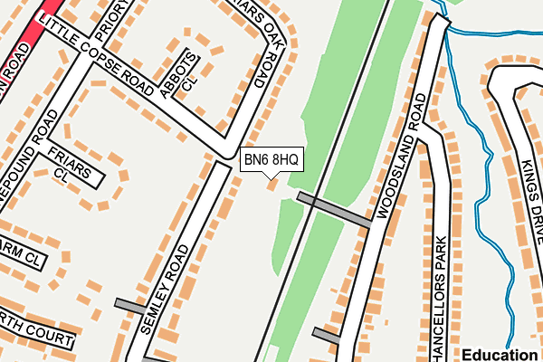
BN6 8HQ lies on Archway Cottages in Hassocks. BN6 8HQ is located in the Hassocks electoral ward, within the local authority district of Mid Sussex and the English Parliamentary constituency of Arundel and South Downs. The Sub Integrated Care Board (ICB) Location is NHS Sussex ICB - 70F and the police force is Sussex. This postcode has been in use since January 1980.


GetTheData
Source: OS OpenMap – Local (Ordnance Survey)
Source: OS VectorMap District (Ordnance Survey)
Licence: Open Government Licence (requires attribution)
| Easting | 530482 |
| Northing | 115869 |
| Latitude | 50.927526 |
| Longitude | -0.144727 |
GetTheData
Source: Open Postcode Geo
Licence: Open Government Licence
| Street | Archway Cottages |
| Town/City | Hassocks |
| Country | England |
| Postcode District | BN6 |
➜ See where BN6 is on a map ➜ Where is Hassocks? | |
GetTheData
Source: Land Registry Price Paid Data
Licence: Open Government Licence
Elevation or altitude of BN6 8HQ as distance above sea level:
| Metres | Feet | |
|---|---|---|
| Elevation | 50m | 164ft |
Elevation is measured from the approximate centre of the postcode, to the nearest point on an OS contour line from OS Terrain 50, which has contour spacing of ten vertical metres.
➜ How high above sea level am I? Find the elevation of your current position using your device's GPS.
GetTheData
Source: Open Postcode Elevation
Licence: Open Government Licence
| Ward | Hassocks |
| Constituency | Arundel And South Downs |
GetTheData
Source: ONS Postcode Database
Licence: Open Government Licence
| Little Copse Road | Hassocks | 236m |
| Kings Drive | Hassocks | 284m |
| Queens Drive | Hassocks | 308m |
| Little Copse Road (London Road) | Hassocks | 311m |
| Little Copse Road (London Road) | Hassocks | 335m |
| Hassocks Station | 0.3km |
| Burgess Hill Station | 3.2km |
| Wivelsfield Station | 4.4km |
GetTheData
Source: NaPTAN
Licence: Open Government Licence
| Percentage of properties with Next Generation Access | 100.0% |
| Percentage of properties with Superfast Broadband | 100.0% |
| Percentage of properties with Ultrafast Broadband | 0.0% |
| Percentage of properties with Full Fibre Broadband | 0.0% |
Superfast Broadband is between 30Mbps and 300Mbps
Ultrafast Broadband is > 300Mbps
| Percentage of properties unable to receive 2Mbps | 0.0% |
| Percentage of properties unable to receive 5Mbps | 0.0% |
| Percentage of properties unable to receive 10Mbps | 0.0% |
| Percentage of properties unable to receive 30Mbps | 0.0% |
GetTheData
Source: Ofcom
Licence: Ofcom Terms of Use (requires attribution)
GetTheData
Source: ONS Postcode Database
Licence: Open Government Licence


➜ Get more ratings from the Food Standards Agency
GetTheData
Source: Food Standards Agency
Licence: FSA terms & conditions
| Last Collection | |||
|---|---|---|---|
| Location | Mon-Fri | Sat | Distance |
| Little Copse Road | 17:30 | 12:30 | 291m |
| Railway Station | 17:45 | 12:30 | 371m |
| Royal Mail 36 Keymer Road | 18:15 | 13:00 | 402m |
GetTheData
Source: Dracos
Licence: Creative Commons Attribution-ShareAlike
The below table lists the International Territorial Level (ITL) codes (formerly Nomenclature of Territorial Units for Statistics (NUTS) codes) and Local Administrative Units (LAU) codes for BN6 8HQ:
| ITL 1 Code | Name |
|---|---|
| TLJ | South East (England) |
| ITL 2 Code | Name |
| TLJ2 | Surrey, East and West Sussex |
| ITL 3 Code | Name |
| TLJ28 | West Sussex (North East) |
| LAU 1 Code | Name |
| E07000228 | Mid Sussex |
GetTheData
Source: ONS Postcode Directory
Licence: Open Government Licence
The below table lists the Census Output Area (OA), Lower Layer Super Output Area (LSOA), and Middle Layer Super Output Area (MSOA) for BN6 8HQ:
| Code | Name | |
|---|---|---|
| OA | E00161878 | |
| LSOA | E01031744 | Mid Sussex 017A |
| MSOA | E02006620 | Mid Sussex 017 |
GetTheData
Source: ONS Postcode Directory
Licence: Open Government Licence
| BN6 8PX | Friars Oak Road | 89m |
| BN6 8PT | Friars Oak Road | 109m |
| BN6 8HG | Woodsland Road | 120m |
| BN6 8PQ | Little Copse Road | 131m |
| BN6 8PD | Semley Road | 141m |
| BN6 8PE | Semley Road | 155m |
| BN6 8PH | Abbots Close | 177m |
| BN6 8ET | Woodsland Road | 178m |
| BN6 8EU | Woodsland Road | 195m |
| BN6 8HT | Woodsland Road | 208m |
GetTheData
Source: Open Postcode Geo; Land Registry Price Paid Data
Licence: Open Government Licence