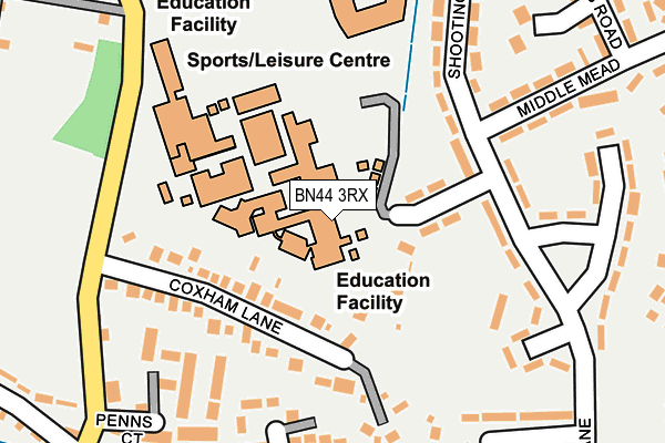
BN44 3RX is located in the Steyning & Ashurst electoral ward, within the local authority district of Horsham and the English Parliamentary constituency of Arundel and South Downs. The Sub Integrated Care Board (ICB) Location is NHS Sussex ICB - 70F and the police force is Sussex. This postcode has been in use since February 1990.


GetTheData
Source: OS OpenMap – Local (Ordnance Survey)
Source: OS VectorMap District (Ordnance Survey)
Licence: Open Government Licence (requires attribution)
| Easting | 517581 |
| Northing | 111754 |
| Latitude | 50.893303 |
| Longitude | -0.329508 |
GetTheData
Source: Open Postcode Geo
Licence: Open Government Licence
| Country | England |
| Postcode District | BN44 |
➜ See where BN44 is on a map ➜ Where is Steyning? | |
GetTheData
Source: Land Registry Price Paid Data
Licence: Open Government Licence
Elevation or altitude of BN44 3RX as distance above sea level:
| Metres | Feet | |
|---|---|---|
| Elevation | 10m | 33ft |
Elevation is measured from the approximate centre of the postcode, to the nearest point on an OS contour line from OS Terrain 50, which has contour spacing of ten vertical metres.
➜ How high above sea level am I? Find the elevation of your current position using your device's GPS.
GetTheData
Source: Open Postcode Elevation
Licence: Open Government Licence
| Ward | Steyning & Ashurst |
| Constituency | Arundel And South Downs |
GetTheData
Source: ONS Postcode Database
Licence: Open Government Licence
| Middle Mead (Shooting Field) | Steyning | 146m |
| Middle Mead (Shooting Field) | Steyning | 167m |
| Leisure Centre (Horsham Road) | Steyning | 185m |
| Leisure Centre (Horsham Road) | Steyning | 197m |
| Breach Close (Tanyard Lane) | Steyning | 308m |
GetTheData
Source: NaPTAN
Licence: Open Government Licence
Estimated total energy consumption in BN44 3RX by fuel type, 2015.
| Consumption (kWh) | 141,654 |
|---|---|
| Meter count | 7 |
| Mean (kWh/meter) | 20,236 |
| Median (kWh/meter) | 18,175 |
GetTheData
Source: Postcode level gas estimates: 2015 (experimental)
Source: Postcode level electricity estimates: 2015 (experimental)
Licence: Open Government Licence
GetTheData
Source: ONS Postcode Database
Licence: Open Government Licence


➜ Get more ratings from the Food Standards Agency
GetTheData
Source: Food Standards Agency
Licence: FSA terms & conditions
| Last Collection | |||
|---|---|---|---|
| Location | Mon-Fri | Sat | Distance |
| Shooting Fields | 17:45 | 11:30 | 311m |
| George Corner | 17:00 | 09:15 | 330m |
| Thornscroft | 17:45 | 11:30 | 339m |
GetTheData
Source: Dracos
Licence: Creative Commons Attribution-ShareAlike
The below table lists the International Territorial Level (ITL) codes (formerly Nomenclature of Territorial Units for Statistics (NUTS) codes) and Local Administrative Units (LAU) codes for BN44 3RX:
| ITL 1 Code | Name |
|---|---|
| TLJ | South East (England) |
| ITL 2 Code | Name |
| TLJ2 | Surrey, East and West Sussex |
| ITL 3 Code | Name |
| TLJ28 | West Sussex (North East) |
| LAU 1 Code | Name |
| E07000227 | Horsham |
GetTheData
Source: ONS Postcode Directory
Licence: Open Government Licence
The below table lists the Census Output Area (OA), Lower Layer Super Output Area (LSOA), and Middle Layer Super Output Area (MSOA) for BN44 3RX:
| Code | Name | |
|---|---|---|
| OA | E00161576 | |
| LSOA | E01031687 | Horsham 014E |
| MSOA | E02006601 | Horsham 014 |
GetTheData
Source: ONS Postcode Directory
Licence: Open Government Licence
| BN44 3LT | Coxham Lane | 138m |
| BN44 3LG | Coxham Lane | 147m |
| BN44 3RQ | Shooting Field | 204m |
| BN44 3BF | Penns Court | 231m |
| BN44 3RZ | Breach Close | 242m |
| BN44 3RG | Middle Mead | 260m |
| BN44 3LJ | Horsham Road | 263m |
| BN44 3SW | Shooting Field | 265m |
| BN44 3RR | Tanyard Lane | 279m |
| BN44 3RH | St Cuthmans Road | 287m |
GetTheData
Source: Open Postcode Geo; Land Registry Price Paid Data
Licence: Open Government Licence