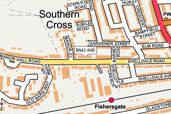
BN42 4NR lies on Manor Hall Road in Southwick, Brighton. BN42 4NR is located in the Eastbrook electoral ward, within the local authority district of Adur and the English Parliamentary constituency of East Worthing and Shoreham. The Sub Integrated Care Board (ICB) Location is NHS Sussex ICB - 70F and the police force is Sussex. This postcode has been in use since July 1990.


GetTheData
Source: OS OpenMap – Local (Ordnance Survey)
Source: OS VectorMap District (Ordnance Survey)
Licence: Open Government Licence (requires attribution)
| Easting | 525416 |
| Northing | 105529 |
| Latitude | 50.835712 |
| Longitude | -0.220318 |
GetTheData
Source: Open Postcode Geo
Licence: Open Government Licence
| Street | Manor Hall Road |
| Locality | Southwick |
| Town/City | Brighton |
| Country | England |
| Postcode District | BN42 |
➜ See where BN42 is on a map ➜ Where is Southwick? | |
GetTheData
Source: Land Registry Price Paid Data
Licence: Open Government Licence
Elevation or altitude of BN42 4NR as distance above sea level:
| Metres | Feet | |
|---|---|---|
| Elevation | 20m | 66ft |
Elevation is measured from the approximate centre of the postcode, to the nearest point on an OS contour line from OS Terrain 50, which has contour spacing of ten vertical metres.
➜ How high above sea level am I? Find the elevation of your current position using your device's GPS.
GetTheData
Source: Open Postcode Elevation
Licence: Open Government Licence
| Ward | Eastbrook |
| Constituency | East Worthing And Shoreham |
GetTheData
Source: ONS Postcode Database
Licence: Open Government Licence
| Fishersgate Station (Manor Hall Road) | Southwick | 18m |
| Fishersgate Station (Manor Hall Road) | Southwick | 22m |
| Shelldale Road | Portslade | 231m |
| Old Barn Way (Manor Hall Road) | Southwick | 244m |
| Old Barn Way (Manor Hall Road) | Southwick | 257m |
| Fishersgate Station | 0.2km |
| Portslade Station | 1.1km |
| Southwick Station | 1.2km |
GetTheData
Source: NaPTAN
Licence: Open Government Licence
| Percentage of properties with Next Generation Access | 100.0% |
| Percentage of properties with Superfast Broadband | 100.0% |
| Percentage of properties with Ultrafast Broadband | 100.0% |
| Percentage of properties with Full Fibre Broadband | 0.0% |
Superfast Broadband is between 30Mbps and 300Mbps
Ultrafast Broadband is > 300Mbps
| Median download speed | 56.9Mbps |
| Average download speed | 72.2Mbps |
| Maximum download speed | 200.00Mbps |
| Median upload speed | 8.4Mbps |
| Average upload speed | 6.4Mbps |
| Maximum upload speed | 10.00Mbps |
| Percentage of properties unable to receive 2Mbps | 0.0% |
| Percentage of properties unable to receive 5Mbps | 0.0% |
| Percentage of properties unable to receive 10Mbps | 0.0% |
| Percentage of properties unable to receive 30Mbps | 0.0% |
GetTheData
Source: Ofcom
Licence: Ofcom Terms of Use (requires attribution)
Estimated total energy consumption in BN42 4NR by fuel type, 2015.
| Consumption (kWh) | 65,838 |
|---|---|
| Meter count | 7 |
| Mean (kWh/meter) | 9,405 |
| Median (kWh/meter) | 9,552 |
GetTheData
Source: Postcode level gas estimates: 2015 (experimental)
Source: Postcode level electricity estimates: 2015 (experimental)
Licence: Open Government Licence
GetTheData
Source: ONS Postcode Database
Licence: Open Government Licence


➜ Get more ratings from the Food Standards Agency
GetTheData
Source: Food Standards Agency
Licence: FSA terms & conditions
| Last Collection | |||
|---|---|---|---|
| Location | Mon-Fri | Sat | Distance |
| Locks Hill | 17:15 | 12:15 | 563m |
| Benfield Way | 17:30 | 12:00 | 900m |
| Church Road Post Office | 17:15 | 12:15 | 904m |
GetTheData
Source: Dracos
Licence: Creative Commons Attribution-ShareAlike
The below table lists the International Territorial Level (ITL) codes (formerly Nomenclature of Territorial Units for Statistics (NUTS) codes) and Local Administrative Units (LAU) codes for BN42 4NR:
| ITL 1 Code | Name |
|---|---|
| TLJ | South East (England) |
| ITL 2 Code | Name |
| TLJ2 | Surrey, East and West Sussex |
| ITL 3 Code | Name |
| TLJ27 | West Sussex (South West) |
| LAU 1 Code | Name |
| E07000223 | Adur |
GetTheData
Source: ONS Postcode Directory
Licence: Open Government Licence
The below table lists the Census Output Area (OA), Lower Layer Super Output Area (LSOA), and Middle Layer Super Output Area (MSOA) for BN42 4NR:
| Code | Name | |
|---|---|---|
| OA | E00159839 | |
| LSOA | E01031349 | Adur 001A |
| MSOA | E02006534 | Adur 001 |
GetTheData
Source: ONS Postcode Directory
Licence: Open Government Licence
| BN42 4NH | Manor Hall Road | 74m |
| BN42 4NW | Manor Close | 75m |
| BN41 1SX | Gardener Street | 83m |
| BN41 1SU | Jubilee Road | 104m |
| BN41 1SY | Barnes Road | 111m |
| BN42 4NU | Farm Way | 123m |
| BN41 1LG | Shelldale Crescent | 143m |
| BN41 1LE | Shelldale Road | 156m |
| BN41 1SS | Wolseley Road | 171m |
| BN41 1ST | Wolseley Road | 187m |
GetTheData
Source: Open Postcode Geo; Land Registry Price Paid Data
Licence: Open Government Licence