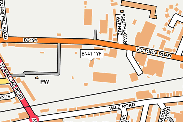
BN41 1YF is located in the South Portslade electoral ward, within the unitary authority of Brighton and Hove and the English Parliamentary constituency of Hove. The Sub Integrated Care Board (ICB) Location is NHS Sussex ICB - 09D and the police force is Sussex. This postcode has been in use since August 1993.


GetTheData
Source: OS OpenMap – Local (Ordnance Survey)
Source: OS VectorMap District (Ordnance Survey)
Licence: Open Government Licence (requires attribution)
| Easting | 526015 |
| Northing | 105583 |
| Latitude | 50.836068 |
| Longitude | -0.211798 |
GetTheData
Source: Open Postcode Geo
Licence: Open Government Licence
| Country | England |
| Postcode District | BN41 |
➜ See where BN41 is on a map ➜ Where is Brighton and Hove? | |
GetTheData
Source: Land Registry Price Paid Data
Licence: Open Government Licence
Elevation or altitude of BN41 1YF as distance above sea level:
| Metres | Feet | |
|---|---|---|
| Elevation | 20m | 66ft |
Elevation is measured from the approximate centre of the postcode, to the nearest point on an OS contour line from OS Terrain 50, which has contour spacing of ten vertical metres.
➜ How high above sea level am I? Find the elevation of your current position using your device's GPS.
GetTheData
Source: Open Postcode Elevation
Licence: Open Government Licence
| Ward | South Portslade |
| Constituency | Hove |
GetTheData
Source: ONS Postcode Database
Licence: Open Government Licence
| Old Town Hall (Victoria Road) | Portslade | 82m |
| Benfield Way (Old Shoreham Road) | Portslade | 263m |
| Battle Of Trafalgar Pub (Victoria Road) | Portslade | 279m |
| Romany Close (Old Shoreham Road) | Portslade | 287m |
| Benfield Way (Old Shoreham Road) | Portslade | 303m |
| Portslade Station | 0.5km |
| Fishersgate Station | 0.6km |
| Southwick Station | 1.7km |
GetTheData
Source: NaPTAN
Licence: Open Government Licence
GetTheData
Source: ONS Postcode Database
Licence: Open Government Licence


➜ Get more ratings from the Food Standards Agency
GetTheData
Source: Food Standards Agency
Licence: FSA terms & conditions
| Last Collection | |||
|---|---|---|---|
| Location | Mon-Fri | Sat | Distance |
| Benfield Way | 17:30 | 12:00 | 366m |
| Church Road Post Office | 17:15 | 12:15 | 382m |
| Boundary Road | 16:00 | 12:30 | 442m |
GetTheData
Source: Dracos
Licence: Creative Commons Attribution-ShareAlike
The below table lists the International Territorial Level (ITL) codes (formerly Nomenclature of Territorial Units for Statistics (NUTS) codes) and Local Administrative Units (LAU) codes for BN41 1YF:
| ITL 1 Code | Name |
|---|---|
| TLJ | South East (England) |
| ITL 2 Code | Name |
| TLJ2 | Surrey, East and West Sussex |
| ITL 3 Code | Name |
| TLJ21 | Brighton and Hove |
| LAU 1 Code | Name |
| E06000043 | Brighton and Hove |
GetTheData
Source: ONS Postcode Directory
Licence: Open Government Licence
The below table lists the Census Output Area (OA), Lower Layer Super Output Area (LSOA), and Middle Layer Super Output Area (MSOA) for BN41 1YF:
| Code | Name | |
|---|---|---|
| OA | E00085737 | |
| LSOA | E01016974 | Brighton and Hove 021A |
| MSOA | E02003511 | Brighton and Hove 021 |
GetTheData
Source: ONS Postcode Directory
Licence: Open Government Licence
| BN41 1XD | Victoria Road | 108m |
| BN41 1GE | Vale Road | 149m |
| BN41 1XB | Victoria Road | 150m |
| BN41 1XE | Southdown Avenue | 157m |
| BN41 1GG | Vale Road | 177m |
| BN41 1GD | Vale Road | 211m |
| BN41 1HA | Vale Road | 216m |
| BN41 1LD | Trafalgar Road | 230m |
| BN41 1GJ | Denmark Road | 236m |
| BN41 1XR | Old Shoreham Road | 252m |
GetTheData
Source: Open Postcode Geo; Land Registry Price Paid Data
Licence: Open Government Licence