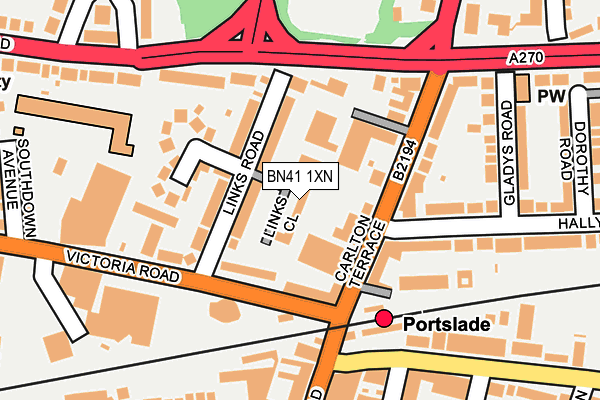
BN41 1XN lies on Links Close in Portslade, Brighton. BN41 1XN is located in the South Portslade electoral ward, within the unitary authority of Brighton and Hove and the English Parliamentary constituency of Hove. The Sub Integrated Care Board (ICB) Location is NHS Sussex ICB - 09D and the police force is Sussex. This postcode has been in use since July 1990.


GetTheData
Source: OS OpenMap – Local (Ordnance Survey)
Source: OS VectorMap District (Ordnance Survey)
Licence: Open Government Licence (requires attribution)
| Easting | 526396 |
| Northing | 105677 |
| Latitude | 50.836830 |
| Longitude | -0.206358 |
GetTheData
Source: Open Postcode Geo
Licence: Open Government Licence
| Street | Links Close |
| Locality | Portslade |
| Town/City | Brighton |
| Country | England |
| Postcode District | BN41 |
➜ See where BN41 is on a map ➜ Where is Brighton and Hove? | |
GetTheData
Source: Land Registry Price Paid Data
Licence: Open Government Licence
Elevation or altitude of BN41 1XN as distance above sea level:
| Metres | Feet | |
|---|---|---|
| Elevation | 20m | 66ft |
Elevation is measured from the approximate centre of the postcode, to the nearest point on an OS contour line from OS Terrain 50, which has contour spacing of ten vertical metres.
➜ How high above sea level am I? Find the elevation of your current position using your device's GPS.
GetTheData
Source: Open Postcode Elevation
Licence: Open Government Licence
| Ward | South Portslade |
| Constituency | Hove |
GetTheData
Source: ONS Postcode Database
Licence: Open Government Licence
| Carlton Terrace | Portslade | 90m |
| Victoria Road East End (Victoria Road) | Portslade | 93m |
| Links Road (Old Shoreham Road) | Portslade | 137m |
| Carlton Terrace | Portslade | 142m |
| Links Road (Old Shoreham Road) | Portslade | 169m |
| Portslade Station | 0.1km |
| Fishersgate Station | 1km |
| Aldrington Station | 1.6km |
GetTheData
Source: NaPTAN
Licence: Open Government Licence
| Percentage of properties with Next Generation Access | 100.0% |
| Percentage of properties with Superfast Broadband | 100.0% |
| Percentage of properties with Ultrafast Broadband | 100.0% |
| Percentage of properties with Full Fibre Broadband | 0.0% |
Superfast Broadband is between 30Mbps and 300Mbps
Ultrafast Broadband is > 300Mbps
| Median download speed | 71.9Mbps |
| Average download speed | 75.6Mbps |
| Maximum download speed | 200.00Mbps |
| Median upload speed | 19.0Mbps |
| Average upload speed | 12.5Mbps |
| Maximum upload speed | 20.00Mbps |
| Percentage of properties unable to receive 2Mbps | 0.0% |
| Percentage of properties unable to receive 5Mbps | 0.0% |
| Percentage of properties unable to receive 10Mbps | 0.0% |
| Percentage of properties unable to receive 30Mbps | 0.0% |
GetTheData
Source: Ofcom
Licence: Ofcom Terms of Use (requires attribution)
Estimated total energy consumption in BN41 1XN by fuel type, 2015.
| Consumption (kWh) | 223,592 |
|---|---|
| Meter count | 23 |
| Mean (kWh/meter) | 9,721 |
| Median (kWh/meter) | 8,951 |
| Consumption (kWh) | 75,142 |
|---|---|
| Meter count | 26 |
| Mean (kWh/meter) | 2,890 |
| Median (kWh/meter) | 2,505 |
GetTheData
Source: Postcode level gas estimates: 2015 (experimental)
Source: Postcode level electricity estimates: 2015 (experimental)
Licence: Open Government Licence
GetTheData
Source: ONS Postcode Database
Licence: Open Government Licence


➜ Get more ratings from the Food Standards Agency
GetTheData
Source: Food Standards Agency
Licence: FSA terms & conditions
| Last Collection | |||
|---|---|---|---|
| Location | Mon-Fri | Sat | Distance |
| Boundary Road | 16:00 | 12:30 | 96m |
| Benfield Way | 17:30 | 12:00 | 233m |
| Church Road Post Office | 17:15 | 12:15 | 365m |
GetTheData
Source: Dracos
Licence: Creative Commons Attribution-ShareAlike
The below table lists the International Territorial Level (ITL) codes (formerly Nomenclature of Territorial Units for Statistics (NUTS) codes) and Local Administrative Units (LAU) codes for BN41 1XN:
| ITL 1 Code | Name |
|---|---|
| TLJ | South East (England) |
| ITL 2 Code | Name |
| TLJ2 | Surrey, East and West Sussex |
| ITL 3 Code | Name |
| TLJ21 | Brighton and Hove |
| LAU 1 Code | Name |
| E06000043 | Brighton and Hove |
GetTheData
Source: ONS Postcode Directory
Licence: Open Government Licence
The below table lists the Census Output Area (OA), Lower Layer Super Output Area (LSOA), and Middle Layer Super Output Area (MSOA) for BN41 1XN:
| Code | Name | |
|---|---|---|
| OA | E00085735 | |
| LSOA | E01016974 | Brighton and Hove 021A |
| MSOA | E02003511 | Brighton and Hove 021 |
GetTheData
Source: ONS Postcode Directory
Licence: Open Government Licence
| BN41 1XG | Links Road | 49m |
| BN41 1XF | Carlton Terrace | 66m |
| BN41 1XH | Links Road | 80m |
| BN41 1XP | Victoria Road | 88m |
| BN41 1XX | Victoria Road | 90m |
| BN3 7GA | Boundary Road | 103m |
| BN41 1XS | Old Shoreham Road | 131m |
| BN3 7GB | Boundary Road | 131m |
| BN41 1XL | Garden Close | 142m |
| BN41 1XJ | The Gardens | 143m |
GetTheData
Source: Open Postcode Geo; Land Registry Price Paid Data
Licence: Open Government Licence