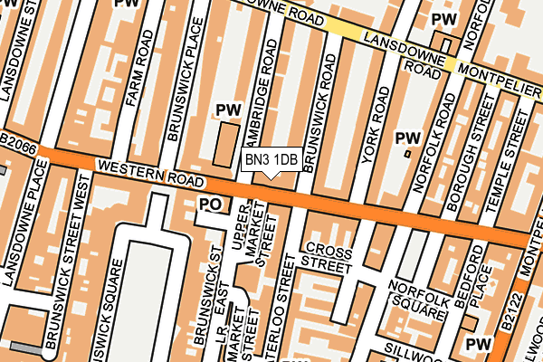
BN3 1DB is located in the Brunswick & Adelaide electoral ward, within the unitary authority of Brighton and Hove and the English Parliamentary constituency of Hove. The Sub Integrated Care Board (ICB) Location is NHS Sussex ICB - 09D and the police force is Sussex. This postcode has been in use since January 1980.


GetTheData
Source: OS OpenMap – Local (Ordnance Survey)
Source: OS VectorMap District (Ordnance Survey)
Licence: Open Government Licence (requires attribution)
| Easting | 529908 |
| Northing | 104510 |
| Latitude | 50.825564 |
| Longitude | -0.156922 |
GetTheData
Source: Open Postcode Geo
Licence: Open Government Licence
| Country | England |
| Postcode District | BN3 |
➜ See where BN3 is on a map ➜ Where is Brighton and Hove? | |
GetTheData
Source: Land Registry Price Paid Data
Licence: Open Government Licence
Elevation or altitude of BN3 1DB as distance above sea level:
| Metres | Feet | |
|---|---|---|
| Elevation | 20m | 66ft |
Elevation is measured from the approximate centre of the postcode, to the nearest point on an OS contour line from OS Terrain 50, which has contour spacing of ten vertical metres.
➜ How high above sea level am I? Find the elevation of your current position using your device's GPS.
GetTheData
Source: Open Postcode Elevation
Licence: Open Government Licence
| Ward | Brunswick & Adelaide |
| Constituency | Hove |
GetTheData
Source: ONS Postcode Database
Licence: Open Government Licence
| Norfolk Square (Western Road) | Brighton | 65m |
| Brunswick Place (Western Road) | Hove | 138m |
| Norfolk Square (Western Road) | Brighton | 166m |
| Brunswick Place (Western Road) | Hove | 185m |
| Lansdowne Road | Hove | 282m |
| Brighton Station | 1.2km |
| Hove Station | 1.4km |
| London Road (Brighton) Station | 1.9km |
GetTheData
Source: NaPTAN
Licence: Open Government Licence
| Median download speed | 66.9Mbps |
| Average download speed | 57.9Mbps |
| Maximum download speed | 79.96Mbps |
| Median upload speed | 18.4Mbps |
| Average upload speed | 14.3Mbps |
| Maximum upload speed | 20.00Mbps |
GetTheData
Source: Ofcom
Licence: Ofcom Terms of Use (requires attribution)
GetTheData
Source: ONS Postcode Database
Licence: Open Government Licence

➜ Get more ratings from the Food Standards Agency
GetTheData
Source: Food Standards Agency
Licence: FSA terms & conditions
| Last Collection | |||
|---|---|---|---|
| Location | Mon-Fri | Sat | Distance |
| Western Road Post Office | 18:30 | 12:00 | 47m |
| Albany Villas | 17:45 | 13:15 | 121m |
| Waterloo Street | 17:45 | 11:30 | 121m |
GetTheData
Source: Dracos
Licence: Creative Commons Attribution-ShareAlike
The below table lists the International Territorial Level (ITL) codes (formerly Nomenclature of Territorial Units for Statistics (NUTS) codes) and Local Administrative Units (LAU) codes for BN3 1DB:
| ITL 1 Code | Name |
|---|---|
| TLJ | South East (England) |
| ITL 2 Code | Name |
| TLJ2 | Surrey, East and West Sussex |
| ITL 3 Code | Name |
| TLJ21 | Brighton and Hove |
| LAU 1 Code | Name |
| E06000043 | Brighton and Hove |
GetTheData
Source: ONS Postcode Directory
Licence: Open Government Licence
The below table lists the Census Output Area (OA), Lower Layer Super Output Area (LSOA), and Middle Layer Super Output Area (MSOA) for BN3 1DB:
| Code | Name | |
|---|---|---|
| OA | E00085040 | |
| LSOA | E01016854 | Brighton and Hove 029C |
| MSOA | E02003519 | Brighton and Hove 029 |
GetTheData
Source: ONS Postcode Directory
Licence: Open Government Licence
| BN3 1AS | Upper Market Street | 60m |
| BN3 1AE | Western Road | 69m |
| BN3 1DD | Western Road | 70m |
| BN3 1BB | Brunswick Street East | 79m |
| BN3 1DG | Brunswick Road | 81m |
| BN3 1AY | Waterloo Street | 82m |
| BN3 1AN | Waterloo Street | 83m |
| BN3 1AL | Farman Street | 87m |
| BN3 1DF | Cambridge Road | 88m |
| BN3 1AF | Western Road | 103m |
GetTheData
Source: Open Postcode Geo; Land Registry Price Paid Data
Licence: Open Government Licence