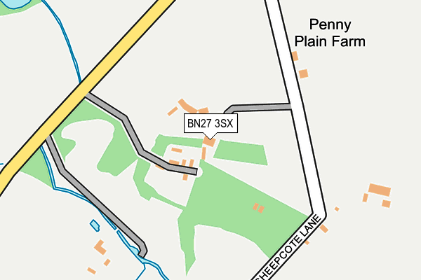
BN27 3SX is in Chalvington, Hailsham. BN27 3SX is located in the Chiddingly, East Hoathly & Waldron electoral ward, within the local authority district of Wealden and the English Parliamentary constituency of Wealden. The Sub Integrated Care Board (ICB) Location is NHS Sussex ICB - 97R and the police force is Sussex. This postcode has been in use since January 1980.


GetTheData
Source: OS OpenMap – Local (Ordnance Survey)
Source: OS VectorMap District (Ordnance Survey)
Licence: Open Government Licence (requires attribution)
| Easting | 553839 |
| Northing | 111263 |
| Latitude | 50.880387 |
| Longitude | 0.185444 |
GetTheData
Source: Open Postcode Geo
Licence: Open Government Licence
| Locality | Chalvington |
| Town/City | Hailsham |
| Country | England |
| Postcode District | BN27 |
➜ See where BN27 is on a map | |
GetTheData
Source: Land Registry Price Paid Data
Licence: Open Government Licence
Elevation or altitude of BN27 3SX as distance above sea level:
| Metres | Feet | |
|---|---|---|
| Elevation | 20m | 66ft |
Elevation is measured from the approximate centre of the postcode, to the nearest point on an OS contour line from OS Terrain 50, which has contour spacing of ten vertical metres.
➜ How high above sea level am I? Find the elevation of your current position using your device's GPS.
GetTheData
Source: Open Postcode Elevation
Licence: Open Government Licence
| Ward | Chiddingly, East Hoathly & Waldron |
| Constituency | Wealden |
GetTheData
Source: ONS Postcode Database
Licence: Open Government Licence
| Deanland Wood Caravan Park (Deanland Road) | Lower Dicker | 1,163m |
| Nash Street (Eastbourne Road) | Lower Dicker | 1,164m |
| The Golden Cross (Ripe Lane) | Golden Cross | 1,165m |
| The Golden Cross (Ripe Lane) | Golden Cross | 1,177m |
| Nash Street (Eastbourne Road) | Lower Dicker | 1,179m |
| Berwick (Sussex) Station | 4.7km |
GetTheData
Source: NaPTAN
Licence: Open Government Licence
| Percentage of properties with Next Generation Access | 100.0% |
| Percentage of properties with Superfast Broadband | 33.3% |
| Percentage of properties with Ultrafast Broadband | 0.0% |
| Percentage of properties with Full Fibre Broadband | 0.0% |
Superfast Broadband is between 30Mbps and 300Mbps
Ultrafast Broadband is > 300Mbps
| Percentage of properties unable to receive 2Mbps | 0.0% |
| Percentage of properties unable to receive 5Mbps | 0.0% |
| Percentage of properties unable to receive 10Mbps | 0.0% |
| Percentage of properties unable to receive 30Mbps | 66.7% |
GetTheData
Source: Ofcom
Licence: Ofcom Terms of Use (requires attribution)
GetTheData
Source: ONS Postcode Database
Licence: Open Government Licence


➜ Get more ratings from the Food Standards Agency
GetTheData
Source: Food Standards Agency
Licence: FSA terms & conditions
| Last Collection | |||
|---|---|---|---|
| Location | Mon-Fri | Sat | Distance |
| Dicker Road | 16:00 | 08:30 | 1,204m |
| Golden Cross | 16:00 | 09:15 | 1,653m |
| Caldicotts | 16:00 | 08:00 | 2,062m |
GetTheData
Source: Dracos
Licence: Creative Commons Attribution-ShareAlike
The below table lists the International Territorial Level (ITL) codes (formerly Nomenclature of Territorial Units for Statistics (NUTS) codes) and Local Administrative Units (LAU) codes for BN27 3SX:
| ITL 1 Code | Name |
|---|---|
| TLJ | South East (England) |
| ITL 2 Code | Name |
| TLJ2 | Surrey, East and West Sussex |
| ITL 3 Code | Name |
| TLJ22 | East Sussex CC |
| LAU 1 Code | Name |
| E07000065 | Wealden |
GetTheData
Source: ONS Postcode Directory
Licence: Open Government Licence
The below table lists the Census Output Area (OA), Lower Layer Super Output Area (LSOA), and Middle Layer Super Output Area (MSOA) for BN27 3SX:
| Code | Name | |
|---|---|---|
| OA | E00107423 | |
| LSOA | E01021147 | Wealden 013B |
| MSOA | E02004415 | Wealden 013 |
GetTheData
Source: ONS Postcode Directory
Licence: Open Government Licence
| BN27 3TA | 544m | |
| BN27 3ST | Chalvington Road | 663m |
| BN27 3RJ | Deanland Road | 897m |
| BN27 3SS | Chalvington Road | 974m |
| BN27 4AJ | 992m | |
| BN27 4AL | Dicker Cottage | 1072m |
| BN27 4AH | 1073m | |
| BN27 3SY | Sheepcote Lane | 1116m |
| BN27 4AN | 1138m | |
| BN8 6JE | 1241m |
GetTheData
Source: Open Postcode Geo; Land Registry Price Paid Data
Licence: Open Government Licence