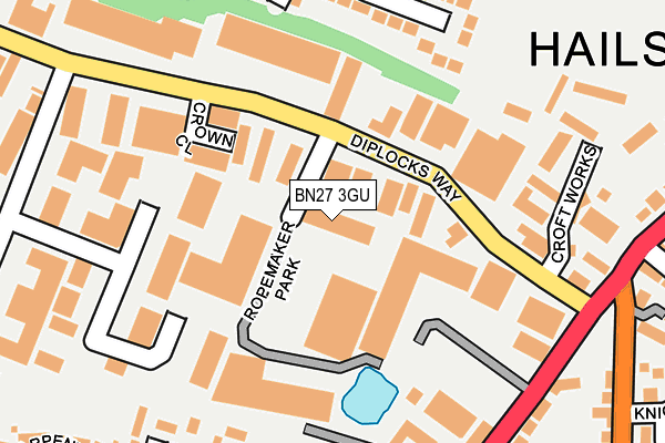
BN27 3GU is located in the Hailsham South electoral ward, within the local authority district of Wealden and the English Parliamentary constituency of Wealden. The Sub Integrated Care Board (ICB) Location is NHS Sussex ICB - 97R and the police force is Sussex. This postcode has been in use since August 2007.


GetTheData
Source: OS OpenMap – Local (Ordnance Survey)
Source: OS VectorMap District (Ordnance Survey)
Licence: Open Government Licence (requires attribution)
| Easting | 558436 |
| Northing | 109140 |
| Latitude | 50.860070 |
| Longitude | 0.249818 |
GetTheData
Source: Open Postcode Geo
Licence: Open Government Licence
| Country | England |
| Postcode District | BN27 |
➜ See where BN27 is on a map ➜ Where is Hailsham? | |
GetTheData
Source: Land Registry Price Paid Data
Licence: Open Government Licence
Elevation or altitude of BN27 3GU as distance above sea level:
| Metres | Feet | |
|---|---|---|
| Elevation | 20m | 66ft |
Elevation is measured from the approximate centre of the postcode, to the nearest point on an OS contour line from OS Terrain 50, which has contour spacing of ten vertical metres.
➜ How high above sea level am I? Find the elevation of your current position using your device's GPS.
GetTheData
Source: Open Postcode Elevation
Licence: Open Government Licence
| Ward | Hailsham South |
| Constituency | Wealden |
GetTheData
Source: ONS Postcode Database
Licence: Open Government Licence
| Ropemaker Park (South Road) | Hailsham | 248m |
| Diplocks Way (South Road) | Hailsham | 250m |
| Bramble Drive | Hailsham | 274m |
| Knights Garden (Ersham Road) | Hailsham | 280m |
| Knights Garden (Ersham Road) | Hailsham | 305m |
| Polegate Station | 4.3km |
GetTheData
Source: NaPTAN
Licence: Open Government Licence
| Median download speed | 80.0Mbps |
| Average download speed | 62.4Mbps |
| Maximum download speed | 80.00Mbps |
| Median upload speed | 20.0Mbps |
| Average upload speed | 15.2Mbps |
| Maximum upload speed | 20.00Mbps |
GetTheData
Source: Ofcom
Licence: Ofcom Terms of Use (requires attribution)
GetTheData
Source: ONS Postcode Database
Licence: Open Government Licence


➜ Get more ratings from the Food Standards Agency
GetTheData
Source: Food Standards Agency
Licence: FSA terms & conditions
| Last Collection | |||
|---|---|---|---|
| Location | Mon-Fri | Sat | Distance |
| Diplocks Way | 17:00 | 12:15 | 212m |
| Western Road | 17:00 | 12:15 | 373m |
| Sandbanks Way | 17:00 | 12:00 | 513m |
GetTheData
Source: Dracos
Licence: Creative Commons Attribution-ShareAlike
The below table lists the International Territorial Level (ITL) codes (formerly Nomenclature of Territorial Units for Statistics (NUTS) codes) and Local Administrative Units (LAU) codes for BN27 3GU:
| ITL 1 Code | Name |
|---|---|
| TLJ | South East (England) |
| ITL 2 Code | Name |
| TLJ2 | Surrey, East and West Sussex |
| ITL 3 Code | Name |
| TLJ22 | East Sussex CC |
| LAU 1 Code | Name |
| E07000065 | Wealden |
GetTheData
Source: ONS Postcode Directory
Licence: Open Government Licence
The below table lists the Census Output Area (OA), Lower Layer Super Output Area (LSOA), and Middle Layer Super Output Area (MSOA) for BN27 3GU:
| Code | Name | |
|---|---|---|
| OA | E00107620 | |
| LSOA | E01021183 | Wealden 016D |
| MSOA | E02004418 | Wealden 016 |
GetTheData
Source: ONS Postcode Directory
Licence: Open Government Licence
| BN27 3GY | South Road | 104m |
| BN27 3JF | Diplocks Way | 115m |
| BN27 3JU | Apex Park | 198m |
| BN27 3JL | Burfield Park Industrial Estate | 198m |
| BN27 3EQ | Bramble Drive | 223m |
| BN27 3EH | Bramble Drive | 229m |
| BN27 3NB | The Holt | 244m |
| BN27 3ND | The Holt | 247m |
| BN27 3JP | South Road | 252m |
| BN27 3YE | The Old Bricklayers | 286m |
GetTheData
Source: Open Postcode Geo; Land Registry Price Paid Data
Licence: Open Government Licence