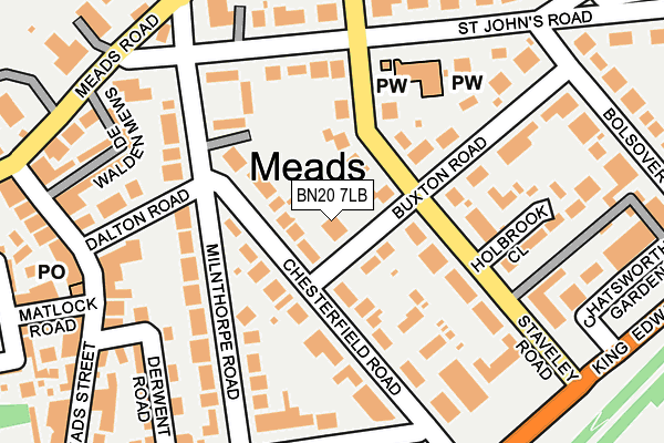
BN20 7LB lies on Buxton Road in Eastbourne. BN20 7LB is located in the Meads electoral ward, within the local authority district of Eastbourne and the English Parliamentary constituency of Eastbourne. The Sub Integrated Care Board (ICB) Location is NHS Sussex ICB - 97R and the police force is Sussex. This postcode has been in use since January 1980.


GetTheData
Source: OS OpenMap – Local (Ordnance Survey)
Source: OS VectorMap District (Ordnance Survey)
Licence: Open Government Licence (requires attribution)
| Easting | 560290 |
| Northing | 97704 |
| Latitude | 50.756802 |
| Longitude | 0.271150 |
GetTheData
Source: Open Postcode Geo
Licence: Open Government Licence
| Street | Buxton Road |
| Town/City | Eastbourne |
| Country | England |
| Postcode District | BN20 |
➜ See where BN20 is on a map ➜ Where is Eastbourne? | |
GetTheData
Source: Land Registry Price Paid Data
Licence: Open Government Licence
Elevation or altitude of BN20 7LB as distance above sea level:
| Metres | Feet | |
|---|---|---|
| Elevation | 40m | 131ft |
Elevation is measured from the approximate centre of the postcode, to the nearest point on an OS contour line from OS Terrain 50, which has contour spacing of ten vertical metres.
➜ How high above sea level am I? Find the elevation of your current position using your device's GPS.
GetTheData
Source: Open Postcode Elevation
Licence: Open Government Licence
| Ward | Meads |
| Constituency | Eastbourne |
GetTheData
Source: ONS Postcode Database
Licence: Open Government Licence
| Chesterfield Road (Milnthorpe Road) | Meads | 108m |
| St John's Road (Milnthorpe Road) | Meads | 226m |
| Hospital Gardens (Chesterfield Road) | Meads | 231m |
| St. John's Road (Meads Road) | Meads | 254m |
| Dalton Road (Meads Street) | Meads | 258m |
| Eastbourne Station | 1.6km |
| Hampden Park (Sussex) Station | 4.4km |
GetTheData
Source: NaPTAN
Licence: Open Government Licence
| Percentage of properties with Next Generation Access | 100.0% |
| Percentage of properties with Superfast Broadband | 100.0% |
| Percentage of properties with Ultrafast Broadband | 0.0% |
| Percentage of properties with Full Fibre Broadband | 0.0% |
Superfast Broadband is between 30Mbps and 300Mbps
Ultrafast Broadband is > 300Mbps
| Percentage of properties unable to receive 2Mbps | 0.0% |
| Percentage of properties unable to receive 5Mbps | 0.0% |
| Percentage of properties unable to receive 10Mbps | 0.0% |
| Percentage of properties unable to receive 30Mbps | 0.0% |
GetTheData
Source: Ofcom
Licence: Ofcom Terms of Use (requires attribution)
GetTheData
Source: ONS Postcode Database
Licence: Open Government Licence


➜ Get more ratings from the Food Standards Agency
GetTheData
Source: Food Standards Agency
Licence: FSA terms & conditions
| Last Collection | |||
|---|---|---|---|
| Location | Mon-Fri | Sat | Distance |
| Stavely Road | 17:30 | 11:00 | 122m |
| Darley Road | 17:30 | 11:00 | 192m |
| St Johns Road | 17:30 | 11:00 | 196m |
GetTheData
Source: Dracos
Licence: Creative Commons Attribution-ShareAlike
The below table lists the International Territorial Level (ITL) codes (formerly Nomenclature of Territorial Units for Statistics (NUTS) codes) and Local Administrative Units (LAU) codes for BN20 7LB:
| ITL 1 Code | Name |
|---|---|
| TLJ | South East (England) |
| ITL 2 Code | Name |
| TLJ2 | Surrey, East and West Sussex |
| ITL 3 Code | Name |
| TLJ22 | East Sussex CC |
| LAU 1 Code | Name |
| E07000061 | Eastbourne |
GetTheData
Source: ONS Postcode Directory
Licence: Open Government Licence
The below table lists the Census Output Area (OA), Lower Layer Super Output Area (LSOA), and Middle Layer Super Output Area (MSOA) for BN20 7LB:
| Code | Name | |
|---|---|---|
| OA | E00106283 | |
| LSOA | E01020931 | Eastbourne 012A |
| MSOA | E02004367 | Eastbourne 012 |
GetTheData
Source: ONS Postcode Directory
Licence: Open Government Licence
| BN20 7LA | Buxton Road | 52m |
| BN20 7LH | Staveley Road | 57m |
| BN20 7NT | Chesterfield Road | 80m |
| BN20 7JX | Staveley Road | 98m |
| BN20 7LJ | Staveley Road | 112m |
| BN20 7NJ | Chesterfield Gardens | 114m |
| BN20 7NU | Chesterfield Road | 120m |
| BN20 7LG | Buxton Road | 130m |
| BN20 7NW | Milnthorpe Gardens | 132m |
| BN20 7NR | Milnthorpe Road | 139m |
GetTheData
Source: Open Postcode Geo; Land Registry Price Paid Data
Licence: Open Government Licence