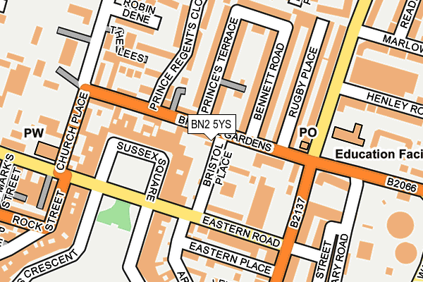
BN2 5YS lies on Bristol Place in Brighton. BN2 5YS is located in the Kemptown electoral ward, within the unitary authority of Brighton and Hove and the English Parliamentary constituency of Brighton, Kemptown. The Sub Integrated Care Board (ICB) Location is NHS Sussex ICB - 09D and the police force is Sussex. This postcode has been in use since August 2013.


GetTheData
Source: OS OpenMap – Local (Ordnance Survey)
Source: OS VectorMap District (Ordnance Survey)
Licence: Open Government Licence (requires attribution)
| Easting | 533327 |
| Northing | 103722 |
| Latitude | 50.817705 |
| Longitude | -0.108693 |
GetTheData
Source: Open Postcode Geo
Licence: Open Government Licence
| Street | Bristol Place |
| Town/City | Brighton |
| Country | England |
| Postcode District | BN2 |
➜ See where BN2 is on a map ➜ Where is Brighton? | |
GetTheData
Source: Land Registry Price Paid Data
Licence: Open Government Licence
Elevation or altitude of BN2 5YS as distance above sea level:
| Metres | Feet | |
|---|---|---|
| Elevation | 30m | 98ft |
Elevation is measured from the approximate centre of the postcode, to the nearest point on an OS contour line from OS Terrain 50, which has contour spacing of ten vertical metres.
➜ How high above sea level am I? Find the elevation of your current position using your device's GPS.
GetTheData
Source: Open Postcode Elevation
Licence: Open Government Licence
| Ward | Kemptown |
| Constituency | Brighton, Kemptown |
GetTheData
Source: ONS Postcode Database
Licence: Open Government Licence
| Lidl Superstore (Eastern Road) | Brighton | 123m |
| Arundel Road | Brighton | 135m |
| Arundel Road | Brighton | 151m |
| Sussex Square (Eastern Road) | Kemp Town | 155m |
| Lidl Superstore (Eastern Road) | Brighton | 158m |
| Brighton Station | 2.6km |
| London Road (Brighton) Station | 2.9km |
| Moulsecoomb Station | 3.3km |
GetTheData
Source: NaPTAN
Licence: Open Government Licence
GetTheData
Source: ONS Postcode Database
Licence: Open Government Licence


➜ Get more ratings from the Food Standards Agency
GetTheData
Source: Food Standards Agency
Licence: FSA terms & conditions
| Last Collection | |||
|---|---|---|---|
| Location | Mon-Fri | Sat | Distance |
| Sussex Square | 16:00 | 11:30 | 181m |
| Rock Street | 17:45 | 13:00 | 282m |
| Arundel Terrace | 17:45 | 12:15 | 311m |
GetTheData
Source: Dracos
Licence: Creative Commons Attribution-ShareAlike
The below table lists the International Territorial Level (ITL) codes (formerly Nomenclature of Territorial Units for Statistics (NUTS) codes) and Local Administrative Units (LAU) codes for BN2 5YS:
| ITL 1 Code | Name |
|---|---|
| TLJ | South East (England) |
| ITL 2 Code | Name |
| TLJ2 | Surrey, East and West Sussex |
| ITL 3 Code | Name |
| TLJ21 | Brighton and Hove |
| LAU 1 Code | Name |
| E06000043 | Brighton and Hove |
GetTheData
Source: ONS Postcode Directory
Licence: Open Government Licence
The below table lists the Census Output Area (OA), Lower Layer Super Output Area (LSOA), and Middle Layer Super Output Area (MSOA) for BN2 5YS:
| Code | Name | |
|---|---|---|
| OA | E00085605 | |
| LSOA | E01016963 | Brighton and Hove 032D |
| MSOA | E02003522 | Brighton and Hove 032 |
GetTheData
Source: ONS Postcode Directory
Licence: Open Government Licence
| BN2 5JY | Sussex Row | 53m |
| BN2 5LJ | Sussex Square Mews | 62m |
| BN2 5AB | Sussex Square | 74m |
| BN2 5JD | Bristol Gardens | 83m |
| BN2 5JR | Bristol Gardens | 85m |
| BN2 5JS | Princes Terrace | 101m |
| BN2 5AD | Sussex Square | 102m |
| BN2 5TW | Eastern Road | 104m |
| BN2 5JL | Bennett Road | 122m |
| BN2 5TX | Arundel Road | 125m |
GetTheData
Source: Open Postcode Geo; Land Registry Price Paid Data
Licence: Open Government Licence