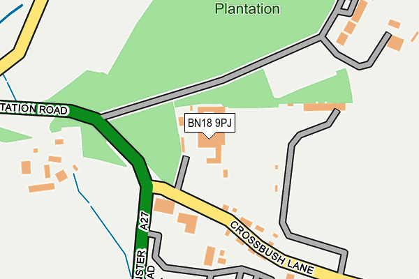
BN18 9PJ is located in the Arundel & Walberton electoral ward, within the local authority district of Arun and the English Parliamentary constituency of Arundel and South Downs. The Sub Integrated Care Board (ICB) Location is NHS Sussex ICB - 70F and the police force is Sussex. This postcode has been in use since January 1980.


GetTheData
Source: OS OpenMap – Local (Ordnance Survey)
Source: OS VectorMap District (Ordnance Survey)
Licence: Open Government Licence (requires attribution)
| Easting | 502931 |
| Northing | 106242 |
| Latitude | 50.846545 |
| Longitude | -0.539285 |
GetTheData
Source: Open Postcode Geo
Licence: Open Government Licence
| Country | England |
| Postcode District | BN18 |
➜ See where BN18 is on a map ➜ Where is Crossbush? | |
GetTheData
Source: Land Registry Price Paid Data
Licence: Open Government Licence
Elevation or altitude of BN18 9PJ as distance above sea level:
| Metres | Feet | |
|---|---|---|
| Elevation | 30m | 98ft |
Elevation is measured from the approximate centre of the postcode, to the nearest point on an OS contour line from OS Terrain 50, which has contour spacing of ten vertical metres.
➜ How high above sea level am I? Find the elevation of your current position using your device's GPS.
GetTheData
Source: Open Postcode Elevation
Licence: Open Government Licence
| Ward | Arundel & Walberton |
| Constituency | Arundel And South Downs |
GetTheData
Source: ONS Postcode Database
Licence: Open Government Licence
| Convent Of Poor Clares (Crossbush Lane) | Crossbush | 79m |
| Crossbush Lane (Arundel Road) | Crossbush | 144m |
| Crossbush Lane (Arundel Road) | Crossbush | 174m |
| Batworth Park Plantation (Unnamed Road) | Warningcamp | 486m |
| Railway Station (The Causeway) | Arundel | 611m |
| Arundel Station | 0.5km |
| Ford Station | 3.4km |
| Littlehampton Station | 4.1km |
GetTheData
Source: NaPTAN
Licence: Open Government Licence
| Percentage of properties with Next Generation Access | 100.0% |
| Percentage of properties with Superfast Broadband | 100.0% |
| Percentage of properties with Ultrafast Broadband | 0.0% |
| Percentage of properties with Full Fibre Broadband | 0.0% |
Superfast Broadband is between 30Mbps and 300Mbps
Ultrafast Broadband is > 300Mbps
| Percentage of properties unable to receive 2Mbps | 0.0% |
| Percentage of properties unable to receive 5Mbps | 0.0% |
| Percentage of properties unable to receive 10Mbps | 0.0% |
| Percentage of properties unable to receive 30Mbps | 0.0% |
GetTheData
Source: Ofcom
Licence: Ofcom Terms of Use (requires attribution)
GetTheData
Source: ONS Postcode Database
Licence: Open Government Licence


➜ Get more ratings from the Food Standards Agency
GetTheData
Source: Food Standards Agency
Licence: FSA terms & conditions
| Last Collection | |||
|---|---|---|---|
| Location | Mon-Fri | Sat | Distance |
| Crossbush | 16:15 | 07:00 | 148m |
| Railway Station | 16:30 | 09:30 | 526m |
| Crossbush House | 16:15 | 07:15 | 606m |
GetTheData
Source: Dracos
Licence: Creative Commons Attribution-ShareAlike
The below table lists the International Territorial Level (ITL) codes (formerly Nomenclature of Territorial Units for Statistics (NUTS) codes) and Local Administrative Units (LAU) codes for BN18 9PJ:
| ITL 1 Code | Name |
|---|---|
| TLJ | South East (England) |
| ITL 2 Code | Name |
| TLJ2 | Surrey, East and West Sussex |
| ITL 3 Code | Name |
| TLJ27 | West Sussex (South West) |
| LAU 1 Code | Name |
| E07000224 | Arun |
GetTheData
Source: ONS Postcode Directory
Licence: Open Government Licence
The below table lists the Census Output Area (OA), Lower Layer Super Output Area (LSOA), and Middle Layer Super Output Area (MSOA) for BN18 9PJ:
| Code | Name | |
|---|---|---|
| OA | E00160071 | |
| LSOA | E01031392 | Arun 001C |
| MSOA | E02006542 | Arun 001 |
GetTheData
Source: ONS Postcode Directory
Licence: Open Government Licence
| BN18 9PG | 293m | |
| BN18 9PQ | Crossbush Lane | 366m |
| BN18 9PL | The Terrace | 549m |
| BN18 9JL | Causeway Villas | 658m |
| BN17 7QQ | Lyminster Road | 756m |
| BN17 7QL | Calceto Lane | 813m |
| BN18 9QU | 915m | |
| BN18 9QT | 986m | |
| BN18 9JJ | The Causeway | 1010m |
| BN18 9QL | Southfield Cottage | 1075m |
GetTheData
Source: Open Postcode Geo; Land Registry Price Paid Data
Licence: Open Government Licence