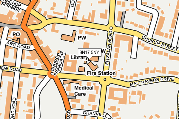
BN17 5NY is located in the River electoral ward, within the local authority district of Arun and the English Parliamentary constituency of Bognor Regis and Littlehampton. The Sub Integrated Care Board (ICB) Location is NHS Sussex ICB - 70F and the police force is Sussex. This postcode has been in use since July 1983.


GetTheData
Source: OS OpenMap – Local (Ordnance Survey)
Source: OS VectorMap District (Ordnance Survey)
Licence: Open Government Licence (requires attribution)
| Easting | 503126 |
| Northing | 101995 |
| Latitude | 50.808340 |
| Longitude | -0.537732 |
GetTheData
Source: Open Postcode Geo
Licence: Open Government Licence
| Country | England |
| Postcode District | BN17 |
➜ See where BN17 is on a map ➜ Where is Littlehampton? | |
GetTheData
Source: Land Registry Price Paid Data
Licence: Open Government Licence
Elevation or altitude of BN17 5NY as distance above sea level:
| Metres | Feet | |
|---|---|---|
| Elevation | 10m | 33ft |
Elevation is measured from the approximate centre of the postcode, to the nearest point on an OS contour line from OS Terrain 50, which has contour spacing of ten vertical metres.
➜ How high above sea level am I? Find the elevation of your current position using your device's GPS.
GetTheData
Source: Open Postcode Elevation
Licence: Open Government Licence
| Ward | River |
| Constituency | Bognor Regis And Littlehampton |
GetTheData
Source: ONS Postcode Database
Licence: Open Government Licence
| Library (Fitzalan Road) | Littlehampton | 52m |
| Library (Fitzalan Road) | Littlehampton | 79m |
| Church Street | Littlehampton | 109m |
| Church Street | Littlehampton | 124m |
| Granville Road (Fitzalan Road) | Littlehampton | 151m |
| Littlehampton Station | 0.6km |
| Angmering Station | 3.5km |
| Ford Station | 3.7km |
GetTheData
Source: NaPTAN
Licence: Open Government Licence
GetTheData
Source: ONS Postcode Database
Licence: Open Government Licence


➜ Get more ratings from the Food Standards Agency
GetTheData
Source: Food Standards Agency
Licence: FSA terms & conditions
| Last Collection | |||
|---|---|---|---|
| Location | Mon-Fri | Sat | Distance |
| Fitzalan Road | 17:15 | 12:00 | 399m |
| Surrey Street | 18:30 | 12:30 | 417m |
| Queen Street | 17:15 | 12:15 | 515m |
GetTheData
Source: Dracos
Licence: Creative Commons Attribution-ShareAlike
The below table lists the International Territorial Level (ITL) codes (formerly Nomenclature of Territorial Units for Statistics (NUTS) codes) and Local Administrative Units (LAU) codes for BN17 5NY:
| ITL 1 Code | Name |
|---|---|
| TLJ | South East (England) |
| ITL 2 Code | Name |
| TLJ2 | Surrey, East and West Sussex |
| ITL 3 Code | Name |
| TLJ27 | West Sussex (South West) |
| LAU 1 Code | Name |
| E07000224 | Arun |
GetTheData
Source: ONS Postcode Directory
Licence: Open Government Licence
The below table lists the Census Output Area (OA), Lower Layer Super Output Area (LSOA), and Middle Layer Super Output Area (MSOA) for BN17 5NY:
| Code | Name | |
|---|---|---|
| OA | E00160395 | |
| LSOA | E01031455 | Arun 009D |
| MSOA | E02006550 | Arun 009 |
GetTheData
Source: ONS Postcode Directory
Licence: Open Government Licence
| BN17 5LX | Maltravers Road | 90m |
| BN17 5EN | Church Street | 128m |
| BN17 5JG | Beach Road | 132m |
| BN17 5FE | Church Street | 133m |
| BN17 5JA | Beach Road | 143m |
| BN17 5PT | Summerlea Gardens | 173m |
| BN17 5NF | Fitzalan Road | 175m |
| BN17 5HT | Beach Road | 186m |
| BN17 5PU | Church Street | 186m |
| BN17 5HZ | Beach Road | 190m |
GetTheData
Source: Open Postcode Geo; Land Registry Price Paid Data
Licence: Open Government Licence