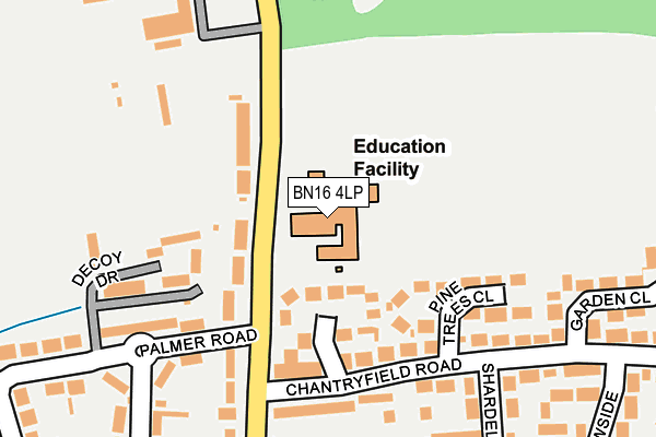
BN16 4LP is located in the Angmering & Findon electoral ward, within the local authority district of Arun and the English Parliamentary constituency of Arundel and South Downs. The Sub Integrated Care Board (ICB) Location is NHS Sussex ICB - 70F and the police force is Sussex. This postcode has been in use since January 1980.


GetTheData
Source: OS OpenMap – Local (Ordnance Survey)
Source: OS VectorMap District (Ordnance Survey)
Licence: Open Government Licence (requires attribution)
| Easting | 506802 |
| Northing | 105156 |
| Latitude | 50.836082 |
| Longitude | -0.484635 |
GetTheData
Source: Open Postcode Geo
Licence: Open Government Licence
| Country | England |
| Postcode District | BN16 |
➜ See where BN16 is on a map ➜ Where is Angmering? | |
GetTheData
Source: Land Registry Price Paid Data
Licence: Open Government Licence
Elevation or altitude of BN16 4LP as distance above sea level:
| Metres | Feet | |
|---|---|---|
| Elevation | 20m | 66ft |
Elevation is measured from the approximate centre of the postcode, to the nearest point on an OS contour line from OS Terrain 50, which has contour spacing of ten vertical metres.
➜ How high above sea level am I? Find the elevation of your current position using your device's GPS.
GetTheData
Source: Open Postcode Elevation
Licence: Open Government Licence
| Ward | Angmering & Findon |
| Constituency | Arundel And South Downs |
GetTheData
Source: ONS Postcode Database
Licence: Open Government Licence
| Shardeloes Road (Chantryfield Road) | Angmering | 202m |
| Shardeloes Road (Chantryfield Road) | Angmering | 216m |
| Chantryfield Road (Arundel Road) | Angmering | 239m |
| Chantryfield Road (Arundel Road) | Angmering | 243m |
| Meadowside (Chantryfield Road) | Angmering | 307m |
| Angmering Station | 2.2km |
| Goring-by-Sea Station | 4.2km |
| Arundel Station | 4.5km |
GetTheData
Source: NaPTAN
Licence: Open Government Licence
GetTheData
Source: ONS Postcode Database
Licence: Open Government Licence


➜ Get more ratings from the Food Standards Agency
GetTheData
Source: Food Standards Agency
Licence: FSA terms & conditions
| Last Collection | |||
|---|---|---|---|
| Location | Mon-Fri | Sat | Distance |
| Harefield Avenue | 16:45 | 11:45 | 801m |
| Angmering Post Office | 17:15 | 12:30 | 811m |
| Bentley Close | 17:00 | 12:15 | 1,500m |
GetTheData
Source: Dracos
Licence: Creative Commons Attribution-ShareAlike
The below table lists the International Territorial Level (ITL) codes (formerly Nomenclature of Territorial Units for Statistics (NUTS) codes) and Local Administrative Units (LAU) codes for BN16 4LP:
| ITL 1 Code | Name |
|---|---|
| TLJ | South East (England) |
| ITL 2 Code | Name |
| TLJ2 | Surrey, East and West Sussex |
| ITL 3 Code | Name |
| TLJ27 | West Sussex (South West) |
| LAU 1 Code | Name |
| E07000224 | Arun |
GetTheData
Source: ONS Postcode Directory
Licence: Open Government Licence
The below table lists the Census Output Area (OA), Lower Layer Super Output Area (LSOA), and Middle Layer Super Output Area (MSOA) for BN16 4LP:
| Code | Name | |
|---|---|---|
| OA | E00160045 | |
| LSOA | E01031386 | Arun 002A |
| MSOA | E02006543 | Arun 002 |
GetTheData
Source: ONS Postcode Directory
Licence: Open Government Licence
| BN16 4LL | Arundel Road | 70m |
| BN16 4LS | Furzefield Close | 97m |
| BN16 4DN | Decoy Drive | 158m |
| BN16 4LR | Chantryfield Road | 158m |
| BN16 4LT | Pine Trees Close | 179m |
| BN16 4LZ | Chantryfield Road | 201m |
| BN16 4LG | Lloyd Goring Close | 242m |
| BN16 4LH | Arundel Road | 253m |
| BN16 4LU | Chantryfield Road | 254m |
| BN16 4LN | Palmer Road | 267m |
GetTheData
Source: Open Postcode Geo; Land Registry Price Paid Data
Licence: Open Government Licence