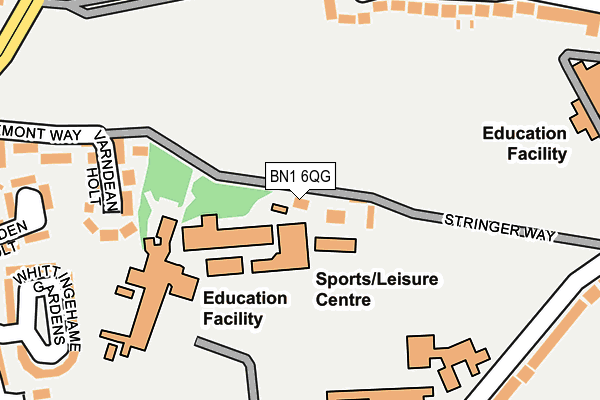
BN1 6QG is located in the Preston Park electoral ward, within the unitary authority of Brighton and Hove and the English Parliamentary constituency of Brighton, Pavilion. The Sub Integrated Care Board (ICB) Location is NHS Sussex ICB - 09D and the police force is Sussex. This postcode has been in use since December 1997.


GetTheData
Source: OS OpenMap – Local (Ordnance Survey)
Source: OS VectorMap District (Ordnance Survey)
Licence: Open Government Licence (requires attribution)
| Easting | 530939 |
| Northing | 107191 |
| Latitude | 50.849428 |
| Longitude | -0.141335 |
GetTheData
Source: Open Postcode Geo
Licence: Open Government Licence
| Country | England |
| Postcode District | BN1 |
➜ See where BN1 is on a map ➜ Where is Brighton? | |
GetTheData
Source: Land Registry Price Paid Data
Licence: Open Government Licence
Elevation or altitude of BN1 6QG as distance above sea level:
| Metres | Feet | |
|---|---|---|
| Elevation | 70m | 230ft |
Elevation is measured from the approximate centre of the postcode, to the nearest point on an OS contour line from OS Terrain 50, which has contour spacing of ten vertical metres.
➜ How high above sea level am I? Find the elevation of your current position using your device's GPS.
GetTheData
Source: Open Postcode Elevation
Licence: Open Government Licence
| Ward | Preston Park |
| Constituency | Brighton, Pavilion |
GetTheData
Source: ONS Postcode Database
Licence: Open Government Licence
| Dorothy Stringer School Grounds (School Grounds) | Brighton | 184m |
| Varndean College (Surrenden Road) | Brighton | 320m |
| Varndean College (Surrenden Road) | Brighton | 347m |
| Friar Crescent (Friar Road) | Brighton | 357m |
| Surrenden Holt (Surrenden Road) | Brighton | 361m |
| Preston Park Station | 1km |
| London Road (Brighton) Station | 1.5km |
| Moulsecoomb Station | 1.6km |
GetTheData
Source: NaPTAN
Licence: Open Government Licence
GetTheData
Source: ONS Postcode Database
Licence: Open Government Licence


➜ Get more ratings from the Food Standards Agency
GetTheData
Source: Food Standards Agency
Licence: FSA terms & conditions
| Last Collection | |||
|---|---|---|---|
| Location | Mon-Fri | Sat | Distance |
| Bates Post Office | 17:30 | 11:45 | 373m |
| Sandgate Road | 16:15 | 10:30 | 481m |
| Dover Road | 16:30 | 10:30 | 557m |
GetTheData
Source: Dracos
Licence: Creative Commons Attribution-ShareAlike
The below table lists the International Territorial Level (ITL) codes (formerly Nomenclature of Territorial Units for Statistics (NUTS) codes) and Local Administrative Units (LAU) codes for BN1 6QG:
| ITL 1 Code | Name |
|---|---|
| TLJ | South East (England) |
| ITL 2 Code | Name |
| TLJ2 | Surrey, East and West Sussex |
| ITL 3 Code | Name |
| TLJ21 | Brighton and Hove |
| LAU 1 Code | Name |
| E06000043 | Brighton and Hove |
GetTheData
Source: ONS Postcode Directory
Licence: Open Government Licence
The below table lists the Census Output Area (OA), Lower Layer Super Output Area (LSOA), and Middle Layer Super Output Area (MSOA) for BN1 6QG:
| Code | Name | |
|---|---|---|
| OA | E00085875 | |
| LSOA | E01017001 | Brighton and Hove 004C |
| MSOA | E02003494 | Brighton and Hove 004 |
GetTheData
Source: ONS Postcode Directory
Licence: Open Government Licence
| BN1 6QX | Varndean Holt | 207m |
| BN1 6NL | Friar Crescent | 249m |
| BN1 6QF | Draxmont Way | 260m |
| BN1 6PN | Loder Road | 279m |
| BN1 6NE | Balfour Road | 282m |
| BN1 6PT | Surrenden Holt | 290m |
| BN1 6PU | Whittingehame Gardens | 311m |
| BN1 6PH | Loder Road | 317m |
| BN1 6QE | Mulberry Close | 340m |
| BN1 6PL | Loder Road | 341m |
GetTheData
Source: Open Postcode Geo; Land Registry Price Paid Data
Licence: Open Government Licence