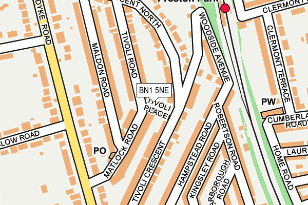
BN1 5NE lies on Tivoli Place in Brighton. BN1 5NE is located in the Preston Park electoral ward, within the unitary authority of Brighton and Hove and the English Parliamentary constituency of Brighton, Pavilion. The Sub Integrated Care Board (ICB) Location is NHS Sussex ICB - 09D and the police force is Sussex. This postcode has been in use since January 1980.


GetTheData
Source: OS OpenMap – Local (Ordnance Survey)
Source: OS VectorMap District (Ordnance Survey)
Licence: Open Government Licence (requires attribution)
| Easting | 529832 |
| Northing | 106608 |
| Latitude | 50.844437 |
| Longitude | -0.157258 |
GetTheData
Source: Open Postcode Geo
Licence: Open Government Licence
| Street | Tivoli Place |
| Town/City | Brighton |
| Country | England |
| Postcode District | BN1 |
➜ See where BN1 is on a map ➜ Where is Brighton? | |
GetTheData
Source: Land Registry Price Paid Data
Licence: Open Government Licence
Elevation or altitude of BN1 5NE as distance above sea level:
| Metres | Feet | |
|---|---|---|
| Elevation | 80m | 262ft |
Elevation is measured from the approximate centre of the postcode, to the nearest point on an OS contour line from OS Terrain 50, which has contour spacing of ten vertical metres.
➜ How high above sea level am I? Find the elevation of your current position using your device's GPS.
GetTheData
Source: Open Postcode Elevation
Licence: Open Government Licence
| Ward | Preston Park |
| Constituency | Brighton, Pavilion |
GetTheData
Source: ONS Postcode Database
Licence: Open Government Licence
| Onslow Road (Dyke Road) | Brighton | 165m |
| Onslow Road (Dyke Road) | Brighton | 180m |
| Top Of Woodruff Avenue (Dyke Road) | Brighton | 211m |
| Top Of Woodruff Avenue (Woodruff Avenue) | Brighton | 262m |
| The Droveway (Dyke Road) | Brighton | 269m |
| Preston Park Station | 0.2km |
| Hove Station | 1.4km |
| London Road (Brighton) Station | 1.7km |
GetTheData
Source: NaPTAN
Licence: Open Government Licence
| Percentage of properties with Next Generation Access | 100.0% |
| Percentage of properties with Superfast Broadband | 100.0% |
| Percentage of properties with Ultrafast Broadband | 100.0% |
| Percentage of properties with Full Fibre Broadband | 0.0% |
Superfast Broadband is between 30Mbps and 300Mbps
Ultrafast Broadband is > 300Mbps
| Percentage of properties unable to receive 2Mbps | 0.0% |
| Percentage of properties unable to receive 5Mbps | 0.0% |
| Percentage of properties unable to receive 10Mbps | 0.0% |
| Percentage of properties unable to receive 30Mbps | 0.0% |
GetTheData
Source: Ofcom
Licence: Ofcom Terms of Use (requires attribution)
GetTheData
Source: ONS Postcode Database
Licence: Open Government Licence


➜ Get more ratings from the Food Standards Agency
GetTheData
Source: Food Standards Agency
Licence: FSA terms & conditions
| Last Collection | |||
|---|---|---|---|
| Location | Mon-Fri | Sat | Distance |
| Matlock Road Post Office | 17:00 | 12:30 | 135m |
| Robertson Road | 16:30 | 12:30 | 150m |
| Shirley Drive No.2 | 16:45 | 13:00 | 207m |
GetTheData
Source: Dracos
Licence: Creative Commons Attribution-ShareAlike
The below table lists the International Territorial Level (ITL) codes (formerly Nomenclature of Territorial Units for Statistics (NUTS) codes) and Local Administrative Units (LAU) codes for BN1 5NE:
| ITL 1 Code | Name |
|---|---|
| TLJ | South East (England) |
| ITL 2 Code | Name |
| TLJ2 | Surrey, East and West Sussex |
| ITL 3 Code | Name |
| TLJ21 | Brighton and Hove |
| LAU 1 Code | Name |
| E06000043 | Brighton and Hove |
GetTheData
Source: ONS Postcode Directory
Licence: Open Government Licence
The below table lists the Census Output Area (OA), Lower Layer Super Output Area (LSOA), and Middle Layer Super Output Area (MSOA) for BN1 5NE:
| Code | Name | |
|---|---|---|
| OA | E00085886 | |
| LSOA | E01017005 | Brighton and Hove 011D |
| MSOA | E02003501 | Brighton and Hove 011 |
GetTheData
Source: ONS Postcode Directory
Licence: Open Government Licence
| BN1 5ND | Tivoli Crescent | 86m |
| BN1 5BF | Matlock Road | 100m |
| BN1 5BG | Tivoli Road | 102m |
| BN1 5BH | Tivoli Road | 109m |
| BN1 5NG | Hampstead Road | 111m |
| BN1 5BE | Maldon Road | 117m |
| BN1 5NB | Tivoli Crescent | 117m |
| BN1 5BD | Maldon Road | 129m |
| BN1 5NF | Woodside Avenue | 148m |
| BN1 5BB | Dyke Road | 156m |
GetTheData
Source: Open Postcode Geo; Land Registry Price Paid Data
Licence: Open Government Licence