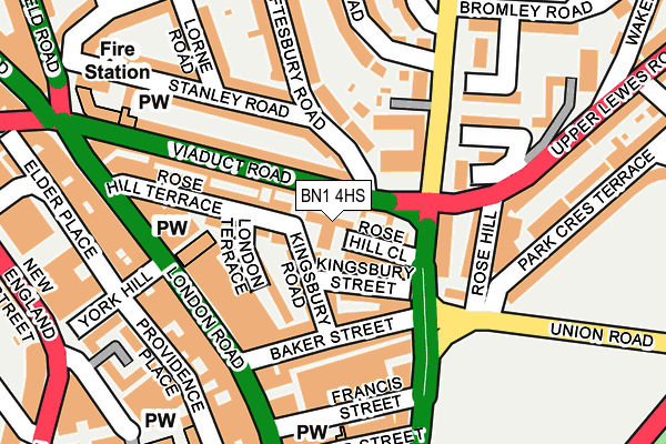
BN1 4HS is located in the West Hill & North Laine electoral ward, within the unitary authority of Brighton and Hove and the English Parliamentary constituency of Brighton, Pavilion. The Sub Integrated Care Board (ICB) Location is NHS Sussex ICB - 09D and the police force is Sussex. This postcode has been in use since February 1984.


GetTheData
Source: OS OpenMap – Local (Ordnance Survey)
Source: OS VectorMap District (Ordnance Survey)
Licence: Open Government Licence (requires attribution)
| Easting | 531406 |
| Northing | 105344 |
| Latitude | 50.832722 |
| Longitude | -0.135367 |
GetTheData
Source: Open Postcode Geo
Licence: Open Government Licence
| Country | England |
| Postcode District | BN1 |
➜ See where BN1 is on a map ➜ Where is Brighton? | |
GetTheData
Source: Land Registry Price Paid Data
Licence: Open Government Licence
Elevation or altitude of BN1 4HS as distance above sea level:
| Metres | Feet | |
|---|---|---|
| Elevation | 20m | 66ft |
Elevation is measured from the approximate centre of the postcode, to the nearest point on an OS contour line from OS Terrain 50, which has contour spacing of ten vertical metres.
➜ How high above sea level am I? Find the elevation of your current position using your device's GPS.
GetTheData
Source: Open Postcode Elevation
Licence: Open Government Licence
| Ward | West Hill & North Laine |
| Constituency | Brighton, Pavilion |
GetTheData
Source: ONS Postcode Database
Licence: Open Government Licence
| Open Market (Ditchling Road) | Brighton | 135m |
| Baker Street (London Road) | Brighton | 136m |
| Open Market (Ditchling Road) | Brighton | 155m |
| York Hill (London Road) | Brighton | 181m |
| Open Market (Oxford Street) | Brighton | 197m |
| London Road (Brighton) Station | 0.4km |
| Brighton Station | 0.6km |
| Moulsecoomb Station | 1.9km |
GetTheData
Source: NaPTAN
Licence: Open Government Licence
| Percentage of properties with Next Generation Access | 100.0% |
| Percentage of properties with Superfast Broadband | 100.0% |
| Percentage of properties with Ultrafast Broadband | 100.0% |
| Percentage of properties with Full Fibre Broadband | 0.0% |
Superfast Broadband is between 30Mbps and 300Mbps
Ultrafast Broadband is > 300Mbps
| Median download speed | 100.0Mbps |
| Average download speed | 107.3Mbps |
| Maximum download speed | 200.00Mbps |
| Median upload speed | 0.8Mbps |
| Average upload speed | 0.8Mbps |
| Maximum upload speed | 0.99Mbps |
| Percentage of properties unable to receive 2Mbps | 0.0% |
| Percentage of properties unable to receive 5Mbps | 0.0% |
| Percentage of properties unable to receive 10Mbps | 0.0% |
| Percentage of properties unable to receive 30Mbps | 0.0% |
GetTheData
Source: Ofcom
Licence: Ofcom Terms of Use (requires attribution)
Estimated total energy consumption in BN1 4HS by fuel type, 2015.
| Consumption (kWh) | 31,362 |
|---|---|
| Meter count | 26 |
| Mean (kWh/meter) | 1,206 |
| Median (kWh/meter) | 1,110 |
GetTheData
Source: Postcode level gas estimates: 2015 (experimental)
Source: Postcode level electricity estimates: 2015 (experimental)
Licence: Open Government Licence
GetTheData
Source: ONS Postcode Database
Licence: Open Government Licence


➜ Get more ratings from the Food Standards Agency
GetTheData
Source: Food Standards Agency
Licence: FSA terms & conditions
| Last Collection | |||
|---|---|---|---|
| Location | Mon-Fri | Sat | Distance |
| Viaduct Road | 18:30 | 12:45 | 48m |
| London Road Post Office | 19:00 | 12:45 | 145m |
| New England Street | 18:30 | 266m | |
GetTheData
Source: Dracos
Licence: Creative Commons Attribution-ShareAlike
The below table lists the International Territorial Level (ITL) codes (formerly Nomenclature of Territorial Units for Statistics (NUTS) codes) and Local Administrative Units (LAU) codes for BN1 4HS:
| ITL 1 Code | Name |
|---|---|
| TLJ | South East (England) |
| ITL 2 Code | Name |
| TLJ2 | Surrey, East and West Sussex |
| ITL 3 Code | Name |
| TLJ21 | Brighton and Hove |
| LAU 1 Code | Name |
| E06000043 | Brighton and Hove |
GetTheData
Source: ONS Postcode Directory
Licence: Open Government Licence
The below table lists the Census Output Area (OA), Lower Layer Super Output Area (LSOA), and Middle Layer Super Output Area (MSOA) for BN1 4HS:
| Code | Name | |
|---|---|---|
| OA | E00085659 | |
| LSOA | E01016964 | Brighton and Hove 027C |
| MSOA | E02003517 | Brighton and Hove 027 |
GetTheData
Source: ONS Postcode Directory
Licence: Open Government Licence
| BN1 4HT | Rose Hill Close | 46m |
| BN1 4JW | Kingsbury Street | 54m |
| BN1 4JR | Kingsbury Road | 62m |
| BN1 4NE | Shaftesbury Road | 72m |
| BN1 4SF | Ditchling Road | 102m |
| BN1 4JL | Rose Hill Terrace | 104m |
| BN1 4JP | London Terrace | 105m |
| BN1 4NB | Viaduct Road | 109m |
| BN1 4ND | Viaduct Road | 110m |
| BN1 4JN | Baker Street | 110m |
GetTheData
Source: Open Postcode Geo; Land Registry Price Paid Data
Licence: Open Government Licence