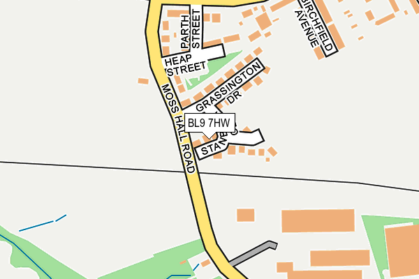
BL9 7HW lies on Stanbury Close in Bury. BL9 7HW is located in the West Heywood electoral ward, within the metropolitan district of Rochdale and the English Parliamentary constituency of Heywood and Middleton. The Sub Integrated Care Board (ICB) Location is NHS Greater Manchester ICB - 01D and the police force is Greater Manchester. This postcode has been in use since December 1995.


GetTheData
Source: OS OpenMap – Local (Ordnance Survey)
Source: OS VectorMap District (Ordnance Survey)
Licence: Open Government Licence (requires attribution)
| Easting | 382967 |
| Northing | 410079 |
| Latitude | 53.587015 |
| Longitude | -2.258774 |
GetTheData
Source: Open Postcode Geo
Licence: Open Government Licence
| Street | Stanbury Close |
| Town/City | Bury |
| Country | England |
| Postcode District | BL9 |
➜ See where BL9 is on a map ➜ Where is Heywood? | |
GetTheData
Source: Land Registry Price Paid Data
Licence: Open Government Licence
Elevation or altitude of BL9 7HW as distance above sea level:
| Metres | Feet | |
|---|---|---|
| Elevation | 110m | 361ft |
Elevation is measured from the approximate centre of the postcode, to the nearest point on an OS contour line from OS Terrain 50, which has contour spacing of ten vertical metres.
➜ How high above sea level am I? Find the elevation of your current position using your device's GPS.
GetTheData
Source: Open Postcode Elevation
Licence: Open Government Licence
| Ward | West Heywood |
| Constituency | Heywood And Middleton |
GetTheData
Source: ONS Postcode Database
Licence: Open Government Licence
| Bury Old Rd/Moss Hall Rd (Bury Old Rd) | Darn Hill | 201m |
| Bury Old Rd/Moss Hall Rd (Bury Old Rd) | Darn Hill | 208m |
| Bury Old Rd/Sussex Ave (Bury Old Rd) | Darn Hill | 322m |
| Bury Old Rd/Sussex Ave (Bury Old Rd) | Darn Hill | 357m |
| Heap Brow/Heap Bridge Primary Sch (Heap Brow) | Heap Bridge | 359m |
GetTheData
Source: NaPTAN
Licence: Open Government Licence
| Percentage of properties with Next Generation Access | 100.0% |
| Percentage of properties with Superfast Broadband | 100.0% |
| Percentage of properties with Ultrafast Broadband | 100.0% |
| Percentage of properties with Full Fibre Broadband | 0.0% |
Superfast Broadband is between 30Mbps and 300Mbps
Ultrafast Broadband is > 300Mbps
| Median download speed | 78.9Mbps |
| Average download speed | 129.3Mbps |
| Maximum download speed | 350.00Mbps |
| Median upload speed | 19.5Mbps |
| Average upload speed | 14.2Mbps |
| Maximum upload speed | 20.00Mbps |
| Percentage of properties unable to receive 2Mbps | 0.0% |
| Percentage of properties unable to receive 5Mbps | 0.0% |
| Percentage of properties unable to receive 10Mbps | 0.0% |
| Percentage of properties unable to receive 30Mbps | 0.0% |
GetTheData
Source: Ofcom
Licence: Ofcom Terms of Use (requires attribution)
Estimated total energy consumption in BL9 7HW by fuel type, 2015.
| Consumption (kWh) | 75,851 |
|---|---|
| Meter count | 8 |
| Mean (kWh/meter) | 9,481 |
| Median (kWh/meter) | 10,303 |
| Consumption (kWh) | 41,518 |
|---|---|
| Meter count | 8 |
| Mean (kWh/meter) | 5,190 |
| Median (kWh/meter) | 4,133 |
GetTheData
Source: Postcode level gas estimates: 2015 (experimental)
Source: Postcode level electricity estimates: 2015 (experimental)
Licence: Open Government Licence
GetTheData
Source: ONS Postcode Database
Licence: Open Government Licence


➜ Get more ratings from the Food Standards Agency
GetTheData
Source: Food Standards Agency
Licence: FSA terms & conditions
| Last Collection | |||
|---|---|---|---|
| Location | Mon-Fri | Sat | Distance |
| Broadfield | 17:30 | 11:15 | 1,164m |
| Houghton Street | 17:40 | 11:10 | 1,769m |
| Fishpool P O | 18:30 | 11:20 | 1,933m |
GetTheData
Source: Dracos
Licence: Creative Commons Attribution-ShareAlike
The below table lists the International Territorial Level (ITL) codes (formerly Nomenclature of Territorial Units for Statistics (NUTS) codes) and Local Administrative Units (LAU) codes for BL9 7HW:
| ITL 1 Code | Name |
|---|---|
| TLD | North West (England) |
| ITL 2 Code | Name |
| TLD3 | Greater Manchester |
| ITL 3 Code | Name |
| TLD37 | Greater Manchester North East |
| LAU 1 Code | Name |
| E08000005 | Rochdale |
GetTheData
Source: ONS Postcode Directory
Licence: Open Government Licence
The below table lists the Census Output Area (OA), Lower Layer Super Output Area (LSOA), and Middle Layer Super Output Area (MSOA) for BL9 7HW:
| Code | Name | |
|---|---|---|
| OA | E00027899 | |
| LSOA | E01005514 | Rochdale 019E |
| MSOA | E02001150 | Rochdale 019 |
GetTheData
Source: ONS Postcode Directory
Licence: Open Government Licence
| BL9 7HU | Laverton Close | 58m |
| BL9 7HN | Grassington Drive | 86m |
| BL9 7JJ | Moss Hall Road | 99m |
| BL9 7JH | Heap Street | 140m |
| BL9 7JQ | Parth Street | 145m |
| BL9 7JG | Bury Old Road | 176m |
| BL9 7JF | Birchfield Avenue | 239m |
| BL9 7JN | Heap Brow | 272m |
| BL9 7JE | Sussex Avenue | 303m |
| BL9 7JB | Bury Old Road | 324m |
GetTheData
Source: Open Postcode Geo; Land Registry Price Paid Data
Licence: Open Government Licence