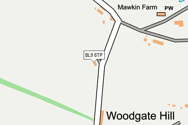
BL9 6TP lies on Kelwood Avenue in Bury. BL9 6TP is located in the Bury East electoral ward, within the metropolitan district of Bury and the English Parliamentary constituency of Bury North. The Sub Integrated Care Board (ICB) Location is NHS Greater Manchester ICB - 00V and the police force is Greater Manchester. This postcode has been in use since January 1980.


GetTheData
Source: OS OpenMap – Local (Ordnance Survey)
Source: OS VectorMap District (Ordnance Survey)
Licence: Open Government Licence (requires attribution)
| Easting | 382698 |
| Northing | 412137 |
| Latitude | 53.605520 |
| Longitude | -2.262950 |
GetTheData
Source: Open Postcode Geo
Licence: Open Government Licence
| Street | Kelwood Avenue |
| Town/City | Bury |
| Country | England |
| Postcode District | BL9 |
➜ See where BL9 is on a map | |
GetTheData
Source: Land Registry Price Paid Data
Licence: Open Government Licence
Elevation or altitude of BL9 6TP as distance above sea level:
| Metres | Feet | |
|---|---|---|
| Elevation | 170m | 558ft |
Elevation is measured from the approximate centre of the postcode, to the nearest point on an OS contour line from OS Terrain 50, which has contour spacing of ten vertical metres.
➜ How high above sea level am I? Find the elevation of your current position using your device's GPS.
GetTheData
Source: Open Postcode Elevation
Licence: Open Government Licence
| Ward | Bury East |
| Constituency | Bury North |
GetTheData
Source: ONS Postcode Database
Licence: Open Government Licence
| Castle Hill (Castle Hill Rd) | Castle Hill | 137m |
| Rochdale Old Rd/Castle Hill Rd (Rochdale Old Rd) | Fairfield General Hospital | 551m |
| Rochdale Old Rd/Castle Hill Rd (Rochdale Old Rd) | Fairfield General Hospital | 560m |
| Rochdale Old Rd/Fairfield Hosp (Rochdale Old Rd) | Fairfield General Hospital | 588m |
| Rochdale Old Rd/Brown Cow Inn (Rochdale Old Rd) | Fairfield General Hospital | 590m |
GetTheData
Source: NaPTAN
Licence: Open Government Licence
| Percentage of properties with Next Generation Access | 100.0% |
| Percentage of properties with Superfast Broadband | 100.0% |
| Percentage of properties with Ultrafast Broadband | 0.0% |
| Percentage of properties with Full Fibre Broadband | 0.0% |
Superfast Broadband is between 30Mbps and 300Mbps
Ultrafast Broadband is > 300Mbps
| Percentage of properties unable to receive 2Mbps | 0.0% |
| Percentage of properties unable to receive 5Mbps | 0.0% |
| Percentage of properties unable to receive 10Mbps | 0.0% |
| Percentage of properties unable to receive 30Mbps | 0.0% |
GetTheData
Source: Ofcom
Licence: Ofcom Terms of Use (requires attribution)
GetTheData
Source: ONS Postcode Database
Licence: Open Government Licence


➜ Get more ratings from the Food Standards Agency
GetTheData
Source: Food Standards Agency
Licence: FSA terms & conditions
| Last Collection | |||
|---|---|---|---|
| Location | Mon-Fri | Sat | Distance |
| 200 Railway Street | 17:40 | 11:00 | 460m |
| 53 Dorset Drive | 17:20 | 10:55 | 2,035m |
| Limefield P O | 17:15 | 11:10 | 2,137m |
GetTheData
Source: Dracos
Licence: Creative Commons Attribution-ShareAlike
The below table lists the International Territorial Level (ITL) codes (formerly Nomenclature of Territorial Units for Statistics (NUTS) codes) and Local Administrative Units (LAU) codes for BL9 6TP:
| ITL 1 Code | Name |
|---|---|
| TLD | North West (England) |
| ITL 2 Code | Name |
| TLD3 | Greater Manchester |
| ITL 3 Code | Name |
| TLD37 | Greater Manchester North East |
| LAU 1 Code | Name |
| E08000002 | Bury |
GetTheData
Source: ONS Postcode Directory
Licence: Open Government Licence
The below table lists the Census Output Area (OA), Lower Layer Super Output Area (LSOA), and Middle Layer Super Output Area (MSOA) for BL9 6TP:
| Code | Name | |
|---|---|---|
| OA | E00025081 | |
| LSOA | E01004954 | Bury 007A |
| MSOA | E02001025 | Bury 007 |
GetTheData
Source: ONS Postcode Directory
Licence: Open Government Licence
| BL9 6UH | Castle Hill Road | 205m |
| BL9 7RS | Woodgate Hill Road | 250m |
| BL9 7RW | Castle Hill Road | 269m |
| BL9 7RU | Woodgate Avenue | 333m |
| BL9 7RT | Woodgate Avenue | 336m |
| BL9 7RP | Sixth Avenue | 383m |
| BL9 7RN | Castle Hill Road | 440m |
| BL9 7RR | Lea Mount Drive | 441m |
| BL9 7TA | Rectory Lane | 454m |
| BL9 7RL | Second Avenue | 473m |
GetTheData
Source: Open Postcode Geo; Land Registry Price Paid Data
Licence: Open Government Licence