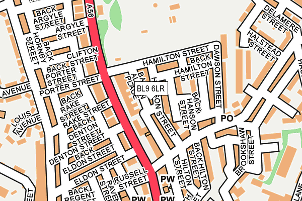
BL9 6LR lies on Hanson Street in Bury. BL9 6LR is located in the Moorside electoral ward, within the metropolitan district of Bury and the English Parliamentary constituency of Bury North. The Sub Integrated Care Board (ICB) Location is NHS Greater Manchester ICB - 00V and the police force is Greater Manchester. This postcode has been in use since January 1980.


GetTheData
Source: OS OpenMap – Local (Ordnance Survey)
Source: OS VectorMap District (Ordnance Survey)
Licence: Open Government Licence (requires attribution)
| Easting | 380891 |
| Northing | 411857 |
| Latitude | 53.602924 |
| Longitude | -2.290244 |
GetTheData
Source: Open Postcode Geo
Licence: Open Government Licence
| Street | Hanson Street |
| Town/City | Bury |
| Country | England |
| Postcode District | BL9 |
➜ See where BL9 is on a map ➜ Where is Bury? | |
GetTheData
Source: Land Registry Price Paid Data
Licence: Open Government Licence
Elevation or altitude of BL9 6LR as distance above sea level:
| Metres | Feet | |
|---|---|---|
| Elevation | 110m | 361ft |
Elevation is measured from the approximate centre of the postcode, to the nearest point on an OS contour line from OS Terrain 50, which has contour spacing of ten vertical metres.
➜ How high above sea level am I? Find the elevation of your current position using your device's GPS.
GetTheData
Source: Open Postcode Elevation
Licence: Open Government Licence
| Ward | Moorside |
| Constituency | Bury North |
GetTheData
Source: ONS Postcode Database
Licence: Open Government Licence
| Walmersley Rd/Chesham Rd (Walmersley Rd) | Fernhill | 88m |
| Chesham Rd/Walmersley Rd (Chesham Rd) | Fernhill | 107m |
| Chesham Rd/Hilton St (Chesham Road) | Fernhill | 119m |
| Walmersley Rd/Chesham Rd (Walmersley Rd) | Fernhill | 167m |
| Chesham Rd/Brookshaw St (Chesham Rd) | Chesham | 171m |
| Bury Bolton Street (East Lancashire Railway) | Bury | 1,217m |
| Bury (Manchester Metrolink) (The Haymarket) | Bury | 1,406m |
GetTheData
Source: NaPTAN
Licence: Open Government Licence
| Percentage of properties with Next Generation Access | 100.0% |
| Percentage of properties with Superfast Broadband | 100.0% |
| Percentage of properties with Ultrafast Broadband | 0.0% |
| Percentage of properties with Full Fibre Broadband | 0.0% |
Superfast Broadband is between 30Mbps and 300Mbps
Ultrafast Broadband is > 300Mbps
| Median download speed | 39.1Mbps |
| Average download speed | 41.1Mbps |
| Maximum download speed | 80.00Mbps |
| Median upload speed | 9.9Mbps |
| Average upload speed | 9.6Mbps |
| Maximum upload speed | 20.00Mbps |
| Percentage of properties unable to receive 2Mbps | 0.0% |
| Percentage of properties unable to receive 5Mbps | 0.0% |
| Percentage of properties unable to receive 10Mbps | 0.0% |
| Percentage of properties unable to receive 30Mbps | 0.0% |
GetTheData
Source: Ofcom
Licence: Ofcom Terms of Use (requires attribution)
Estimated total energy consumption in BL9 6LR by fuel type, 2015.
| Consumption (kWh) | 509,985 |
|---|---|
| Meter count | 47 |
| Mean (kWh/meter) | 10,851 |
| Median (kWh/meter) | 8,558 |
| Consumption (kWh) | 132,940 |
|---|---|
| Meter count | 54 |
| Mean (kWh/meter) | 2,462 |
| Median (kWh/meter) | 1,879 |
GetTheData
Source: Postcode level gas estimates: 2015 (experimental)
Source: Postcode level electricity estimates: 2015 (experimental)
Licence: Open Government Licence
GetTheData
Source: ONS Postcode Database
Licence: Open Government Licence


➜ Get more ratings from the Food Standards Agency
GetTheData
Source: Food Standards Agency
Licence: FSA terms & conditions
| Last Collection | |||
|---|---|---|---|
| Location | Mon-Fri | Sat | Distance |
| Hornby Buildings | 18:30 | 11:00 | 943m |
| Limefield P O | 17:15 | 11:10 | 1,131m |
| Bolton Street Station | 18:40 | 11:20 | 1,233m |
GetTheData
Source: Dracos
Licence: Creative Commons Attribution-ShareAlike
The below table lists the International Territorial Level (ITL) codes (formerly Nomenclature of Territorial Units for Statistics (NUTS) codes) and Local Administrative Units (LAU) codes for BL9 6LR:
| ITL 1 Code | Name |
|---|---|
| TLD | North West (England) |
| ITL 2 Code | Name |
| TLD3 | Greater Manchester |
| ITL 3 Code | Name |
| TLD37 | Greater Manchester North East |
| LAU 1 Code | Name |
| E08000002 | Bury |
GetTheData
Source: ONS Postcode Directory
Licence: Open Government Licence
The below table lists the Census Output Area (OA), Lower Layer Super Output Area (LSOA), and Middle Layer Super Output Area (MSOA) for BL9 6LR:
| Code | Name | |
|---|---|---|
| OA | E00025205 | |
| LSOA | E01004980 | Bury 008D |
| MSOA | E02001026 | Bury 008 |
GetTheData
Source: ONS Postcode Directory
Licence: Open Government Licence
| BL9 6LL | Walmersley Road | 60m |
| BL9 6LP | St Annes Street | 60m |
| BL9 5DE | Walmersley Road | 85m |
| BL9 6LN | Hamilton Street | 103m |
| BL9 6LS | Chesham Road | 120m |
| BL9 5EH | Rake Street | 148m |
| BL9 6LW | Dawson Street | 153m |
| BL9 5EJ | Denton Street | 159m |
| BL9 6LX | Lathom Street | 160m |
| BL9 6LT | Hilton Street | 165m |
GetTheData
Source: Open Postcode Geo; Land Registry Price Paid Data
Licence: Open Government Licence