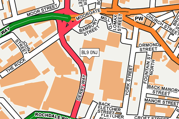
BL9 0NJ is located in the Bury East electoral ward, within the metropolitan district of Bury and the English Parliamentary constituency of Bury North. The Sub Integrated Care Board (ICB) Location is NHS Greater Manchester ICB - 00V and the police force is Greater Manchester. This postcode has been in use since July 2008.


GetTheData
Source: OS OpenMap – Local (Ordnance Survey)
Source: OS VectorMap District (Ordnance Survey)
Licence: Open Government Licence (requires attribution)
| Easting | 380997 |
| Northing | 411034 |
| Latitude | 53.595530 |
| Longitude | -2.288591 |
GetTheData
Source: Open Postcode Geo
Licence: Open Government Licence
| Country | England |
| Postcode District | BL9 |
➜ See where BL9 is on a map ➜ Where is Bury? | |
GetTheData
Source: Land Registry Price Paid Data
Licence: Open Government Licence
Elevation or altitude of BL9 0NJ as distance above sea level:
| Metres | Feet | |
|---|---|---|
| Elevation | 100m | 328ft |
Elevation is measured from the approximate centre of the postcode, to the nearest point on an OS contour line from OS Terrain 50, which has contour spacing of ten vertical metres.
➜ How high above sea level am I? Find the elevation of your current position using your device's GPS.
GetTheData
Source: Open Postcode Elevation
Licence: Open Government Licence
| Ward | Bury East |
| Constituency | Bury North |
GetTheData
Source: ONS Postcode Database
Licence: Open Government Licence
| Derby Way/Moorgate Pct (Derby Way) | Bury | 73m |
| Derby Way/The Rock (Derby Way) | Bury | 91m |
| Moorgate/Old Blue Bell (Bell Lane) | Bury | 166m |
| Walmersley Rd/Moorgate (Walmersley Rd) | Bury | 201m |
| First Bus Depot (Rochdale Rd) | Bury | 215m |
| Bury (Manchester Metrolink) (The Haymarket) | Bury | 759m |
| Bury Bolton Street (East Lancashire Railway) | Bury | 769m |
GetTheData
Source: NaPTAN
Licence: Open Government Licence
GetTheData
Source: ONS Postcode Database
Licence: Open Government Licence


➜ Get more ratings from the Food Standards Agency
GetTheData
Source: Food Standards Agency
Licence: FSA terms & conditions
| Last Collection | |||
|---|---|---|---|
| Location | Mon-Fri | Sat | Distance |
| Hornby Buildings | 18:30 | 11:00 | 371m |
| Bolton Street Station | 18:40 | 11:20 | 796m |
| Houghton Street | 17:40 | 11:10 | 949m |
GetTheData
Source: Dracos
Licence: Creative Commons Attribution-ShareAlike
The below table lists the International Territorial Level (ITL) codes (formerly Nomenclature of Territorial Units for Statistics (NUTS) codes) and Local Administrative Units (LAU) codes for BL9 0NJ:
| ITL 1 Code | Name |
|---|---|
| TLD | North West (England) |
| ITL 2 Code | Name |
| TLD3 | Greater Manchester |
| ITL 3 Code | Name |
| TLD37 | Greater Manchester North East |
| LAU 1 Code | Name |
| E08000002 | Bury |
GetTheData
Source: ONS Postcode Directory
Licence: Open Government Licence
The below table lists the Census Output Area (OA), Lower Layer Super Output Area (LSOA), and Middle Layer Super Output Area (MSOA) for BL9 0NJ:
| Code | Name | |
|---|---|---|
| OA | E00025425 | |
| LSOA | E01005024 | Bury 008E |
| MSOA | E02001026 | Bury 008 |
GetTheData
Source: ONS Postcode Directory
Licence: Open Government Licence
| BL9 0NP | St Johns Gardens | 155m |
| BL9 7AF | Moorgate | 159m |
| BL9 7AH | York Street | 175m |
| BL9 6AS | Wash Lane | 178m |
| BL9 0QY | St Johns Gardens | 186m |
| BL9 7AT | Fletcher Street | 191m |
| BL9 6AR | Bell Lane | 209m |
| BL9 0JQ | South Street | 211m |
| BL9 0NH | John Street | 213m |
| BL9 0ND | The Rock | 265m |
GetTheData
Source: Open Postcode Geo; Land Registry Price Paid Data
Licence: Open Government Licence