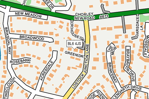
BL6 4JS lies on Green Drive in Lostock, Bolton. BL6 4JS is located in the Heaton, Lostock & Chew Moor electoral ward, within the metropolitan district of Bolton and the English Parliamentary constituency of Bolton West. The Sub Integrated Care Board (ICB) Location is NHS Greater Manchester ICB - 00T and the police force is Greater Manchester. This postcode has been in use since January 1980.


GetTheData
Source: OS OpenMap – Local (Ordnance Survey)
Source: OS VectorMap District (Ordnance Survey)
Licence: Open Government Licence (requires attribution)
| Easting | 367358 |
| Northing | 409138 |
| Latitude | 53.577814 |
| Longitude | -2.494459 |
GetTheData
Source: Open Postcode Geo
Licence: Open Government Licence
| Street | Green Drive |
| Locality | Lostock |
| Town/City | Bolton |
| Country | England |
| Postcode District | BL6 |
➜ See where BL6 is on a map ➜ Where is Bolton? | |
GetTheData
Source: Land Registry Price Paid Data
Licence: Open Government Licence
Elevation or altitude of BL6 4JS as distance above sea level:
| Metres | Feet | |
|---|---|---|
| Elevation | 120m | 394ft |
Elevation is measured from the approximate centre of the postcode, to the nearest point on an OS contour line from OS Terrain 50, which has contour spacing of ten vertical metres.
➜ How high above sea level am I? Find the elevation of your current position using your device's GPS.
GetTheData
Source: Open Postcode Elevation
Licence: Open Government Licence
| Ward | Heaton, Lostock & Chew Moor |
| Constituency | Bolton West |
GetTheData
Source: ONS Postcode Database
Licence: Open Government Licence
1, GREEN DRIVE, LOSTOCK, BOLTON, BL6 4JS 2020 31 JUL £410,000 |
2, GREEN DRIVE, LOSTOCK, BOLTON, BL6 4JS 2018 2 MAR £445,000 |
3, GREEN DRIVE, LOSTOCK, BOLTON, BL6 4JS 2016 29 NOV £540,000 |
GetTheData
Source: HM Land Registry Price Paid Data
Licence: Contains HM Land Registry data © Crown copyright and database right 2025. This data is licensed under the Open Government Licence v3.0.
| Chorley New Rd/Lostock Junction Lane (Chorley New Rd) | Lostock | 118m |
| Chorley New Rd/Lostock Junction Lane (Chorley New Rd) | Lostock | 159m |
| Chorley New Rd/Ravensdale Road (Chorley New Rd) | Lostock | 280m |
| Chorley New Rd/Hollinhurst Drive (Chorley New Rd) | Lostock | 324m |
| Chorley New Rd/Old Hall Clough (Chorley New Rd) | Lostock | 352m |
| Lostock Station | 0.5km |
| Horwich Parkway Station | 3km |
| Westhoughton Station | 3.1km |
GetTheData
Source: NaPTAN
Licence: Open Government Licence
| Percentage of properties with Next Generation Access | 100.0% |
| Percentage of properties with Superfast Broadband | 100.0% |
| Percentage of properties with Ultrafast Broadband | 50.0% |
| Percentage of properties with Full Fibre Broadband | 0.0% |
Superfast Broadband is between 30Mbps and 300Mbps
Ultrafast Broadband is > 300Mbps
| Percentage of properties unable to receive 2Mbps | 0.0% |
| Percentage of properties unable to receive 5Mbps | 0.0% |
| Percentage of properties unable to receive 10Mbps | 0.0% |
| Percentage of properties unable to receive 30Mbps | 0.0% |
GetTheData
Source: Ofcom
Licence: Ofcom Terms of Use (requires attribution)
Estimated total energy consumption in BL6 4JS by fuel type, 2015.
| Consumption (kWh) | 128,240 |
|---|---|
| Meter count | 6 |
| Mean (kWh/meter) | 21,373 |
| Median (kWh/meter) | 21,236 |
GetTheData
Source: Postcode level gas estimates: 2015 (experimental)
Source: Postcode level electricity estimates: 2015 (experimental)
Licence: Open Government Licence
GetTheData
Source: ONS Postcode Database
Licence: Open Government Licence


➜ Get more ratings from the Food Standards Agency
GetTheData
Source: Food Standards Agency
Licence: FSA terms & conditions
| Last Collection | |||
|---|---|---|---|
| Location | Mon-Fri | Sat | Distance |
| Lever Street Little Lever | 17:30 | 11:05 | 2,309m |
| 77 Tudor Avenue | 16:30 | 11:10 | 2,540m |
| Devonshire Road | 17:25 | 11:40 | 2,646m |
GetTheData
Source: Dracos
Licence: Creative Commons Attribution-ShareAlike
The below table lists the International Territorial Level (ITL) codes (formerly Nomenclature of Territorial Units for Statistics (NUTS) codes) and Local Administrative Units (LAU) codes for BL6 4JS:
| ITL 1 Code | Name |
|---|---|
| TLD | North West (England) |
| ITL 2 Code | Name |
| TLD3 | Greater Manchester |
| ITL 3 Code | Name |
| TLD36 | Greater Manchester North West |
| LAU 1 Code | Name |
| E08000001 | Bolton |
GetTheData
Source: ONS Postcode Directory
Licence: Open Government Licence
The below table lists the Census Output Area (OA), Lower Layer Super Output Area (LSOA), and Middle Layer Super Output Area (MSOA) for BL6 4JS:
| Code | Name | |
|---|---|---|
| OA | E00024536 | |
| LSOA | E01004844 | Bolton 020D |
| MSOA | E02001003 | Bolton 020 |
GetTheData
Source: ONS Postcode Directory
Licence: Open Government Licence
| BL6 4JX | Lower House Drive | 48m |
| BL6 4JR | Lostock Junction Lane | 75m |
| BL6 4JU | Chorley New Road | 99m |
| BL6 4JT | Chorley New Road | 110m |
| BL6 4PJ | Acresdale | 115m |
| BL6 4PD | Broadwood | 161m |
| BL1 5DP | Chorley New Road | 165m |
| BL1 5XN | The Meadow | 171m |
| BL1 5XG | Brinksway | 183m |
| BL6 4JY | Chorley New Road | 191m |
GetTheData
Source: Open Postcode Geo; Land Registry Price Paid Data
Licence: Open Government Licence