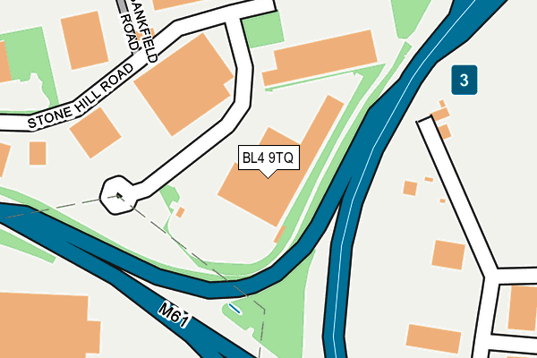
BL4 9TQ is located in the Farnworth South electoral ward, within the metropolitan district of Bolton and the English Parliamentary constituency of Bolton South East. The Sub Integrated Care Board (ICB) Location is NHS Greater Manchester ICB - 00T and the police force is Greater Manchester. This postcode has been in use since November 2010.


GetTheData
Source: OS OpenMap – Local (Ordnance Survey)
Source: OS VectorMap District (Ordnance Survey)
Licence: Open Government Licence (requires attribution)
| Easting | 374067 |
| Northing | 404732 |
| Latitude | 53.538589 |
| Longitude | -2.392770 |
GetTheData
Source: Open Postcode Geo
Licence: Open Government Licence
| Country | England |
| Postcode District | BL4 |
➜ See where BL4 is on a map ➜ Where is Farnworth? | |
GetTheData
Source: Land Registry Price Paid Data
Licence: Open Government Licence
Elevation or altitude of BL4 9TQ as distance above sea level:
| Metres | Feet | |
|---|---|---|
| Elevation | 100m | 328ft |
Elevation is measured from the approximate centre of the postcode, to the nearest point on an OS contour line from OS Terrain 50, which has contour spacing of ten vertical metres.
➜ How high above sea level am I? Find the elevation of your current position using your device's GPS.
GetTheData
Source: Open Postcode Elevation
Licence: Open Government Licence
| Ward | Farnworth South |
| Constituency | Bolton South East |
GetTheData
Source: ONS Postcode Database
Licence: Open Government Licence
| Worsley Rd Nth/Martial Arts Ctr (Worsley Rd Nth) | Hill Top | 488m |
| Worsley Rd Nth/Martial Arts Ctr (Worsley Rd Nth) | Hill Top | 491m |
| Worsley Rd/Halfway House (Worsley Rd) | New Bury | 520m |
| Worsley Rd/Bloomfield Rd (Worsley Rd) | New Bury | 537m |
| Worsley Rd Nth/Hirst Ave (Worsley Rd Nth) | Hill Top | 562m |
| Farnworth Station | 1.3km |
| Kearsley Station | 1.3km |
| Moses Gate Station | 2km |
GetTheData
Source: NaPTAN
Licence: Open Government Licence
GetTheData
Source: ONS Postcode Database
Licence: Open Government Licence


➜ Get more ratings from the Food Standards Agency
GetTheData
Source: Food Standards Agency
Licence: FSA terms & conditions
| Last Collection | |||
|---|---|---|---|
| Location | Mon-Fri | Sat | Distance |
| Bridgeman Street/Fletcher St | 17:40 | 11:20 | 453m |
| Manchester Road Kearsley | 17:30 | 11:20 | 817m |
| Farnworth Station | 18:00 | 11:05 | 867m |
GetTheData
Source: Dracos
Licence: Creative Commons Attribution-ShareAlike
The below table lists the International Territorial Level (ITL) codes (formerly Nomenclature of Territorial Units for Statistics (NUTS) codes) and Local Administrative Units (LAU) codes for BL4 9TQ:
| ITL 1 Code | Name |
|---|---|
| TLD | North West (England) |
| ITL 2 Code | Name |
| TLD3 | Greater Manchester |
| ITL 3 Code | Name |
| TLD36 | Greater Manchester North West |
| LAU 1 Code | Name |
| E08000001 | Bolton |
GetTheData
Source: ONS Postcode Directory
Licence: Open Government Licence
The below table lists the Census Output Area (OA), Lower Layer Super Output Area (LSOA), and Middle Layer Super Output Area (MSOA) for BL4 9TQ:
| Code | Name | |
|---|---|---|
| OA | E00024845 | |
| LSOA | E01004908 | Bolton 034E |
| MSOA | E02001017 | Bolton 034 |
GetTheData
Source: ONS Postcode Directory
Licence: Open Government Licence
| BL4 9XY | Stone Hill Road | 1m |
| BL4 9TP | Express Trading Estate | 149m |
| BL4 8HS | Moss Road | 201m |
| BL4 9LH | Lark Hill | 378m |
| BL4 9LL | Conway Street | 408m |
| BL4 9LD | Percy Street | 419m |
| BL4 8BF | Grundy Road | 433m |
| BL4 8BL | Crompton Street | 437m |
| BL4 8HP | Crompton Street | 456m |
| BL4 9LA | Glass Street | 457m |
GetTheData
Source: Open Postcode Geo; Land Registry Price Paid Data
Licence: Open Government Licence