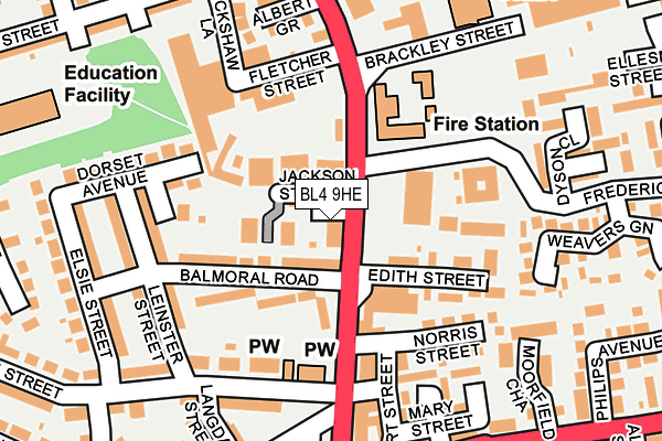
BL4 9HE lies on Albert Road in Farnworth, Bolton. BL4 9HE is located in the Farnworth South electoral ward, within the metropolitan district of Bolton and the English Parliamentary constituency of Bolton South East. The Sub Integrated Care Board (ICB) Location is NHS Greater Manchester ICB - 00T and the police force is Greater Manchester. This postcode has been in use since January 1980.


GetTheData
Source: OS OpenMap – Local (Ordnance Survey)
Source: OS VectorMap District (Ordnance Survey)
Licence: Open Government Licence (requires attribution)
| Easting | 373602 |
| Northing | 405528 |
| Latitude | 53.545720 |
| Longitude | -2.399853 |
GetTheData
Source: Open Postcode Geo
Licence: Open Government Licence
| Street | Albert Road |
| Locality | Farnworth |
| Town/City | Bolton |
| Country | England |
| Postcode District | BL4 |
➜ See where BL4 is on a map ➜ Where is Farnworth? | |
GetTheData
Source: Land Registry Price Paid Data
Licence: Open Government Licence
Elevation or altitude of BL4 9HE as distance above sea level:
| Metres | Feet | |
|---|---|---|
| Elevation | 110m | 361ft |
Elevation is measured from the approximate centre of the postcode, to the nearest point on an OS contour line from OS Terrain 50, which has contour spacing of ten vertical metres.
➜ How high above sea level am I? Find the elevation of your current position using your device's GPS.
GetTheData
Source: Open Postcode Elevation
Licence: Open Government Licence
| Ward | Farnworth South |
| Constituency | Bolton South East |
GetTheData
Source: ONS Postcode Database
Licence: Open Government Licence
142, ALBERT ROAD, FARNWORTH, BOLTON, BL4 9HE 2010 12 JUL £135,000 |
GetTheData
Source: HM Land Registry Price Paid Data
Licence: Contains HM Land Registry data © Crown copyright and database right 2025. This data is licensed under the Open Government Licence v3.0.
| Albert Rd/The Royal Hotel (Albert Rd) | Farnworth | 32m |
| Albert Rd/Balmoral Rd (Albert Rd) | Farnworth | 42m |
| Albert Rd/King St (Albert Rd) | Farnworth | 164m |
| Piggott Street (Swbnd) (Piggott Street) | Farnworth | 182m |
| Albert Rd/King St (Albert Rd) | Farnworth | 192m |
| Farnworth Station | 0.9km |
| Moses Gate Station | 1.1km |
| Kearsley Station | 1.6km |
GetTheData
Source: NaPTAN
Licence: Open Government Licence
GetTheData
Source: ONS Postcode Database
Licence: Open Government Licence


➜ Get more ratings from the Food Standards Agency
GetTheData
Source: Food Standards Agency
Licence: FSA terms & conditions
| Last Collection | |||
|---|---|---|---|
| Location | Mon-Fri | Sat | Distance |
| Manchester Road Kearsley | 17:30 | 11:20 | 152m |
| Farnworth Station | 18:00 | 11:05 | 227m |
| 119 Harper Green Road | 17:40 | 12:55 | 387m |
GetTheData
Source: Dracos
Licence: Creative Commons Attribution-ShareAlike
The below table lists the International Territorial Level (ITL) codes (formerly Nomenclature of Territorial Units for Statistics (NUTS) codes) and Local Administrative Units (LAU) codes for BL4 9HE:
| ITL 1 Code | Name |
|---|---|
| TLD | North West (England) |
| ITL 2 Code | Name |
| TLD3 | Greater Manchester |
| ITL 3 Code | Name |
| TLD36 | Greater Manchester North West |
| LAU 1 Code | Name |
| E08000001 | Bolton |
GetTheData
Source: ONS Postcode Directory
Licence: Open Government Licence
The below table lists the Census Output Area (OA), Lower Layer Super Output Area (LSOA), and Middle Layer Super Output Area (MSOA) for BL4 9HE:
| Code | Name | |
|---|---|---|
| OA | E00024600 | |
| LSOA | E01004860 | Bolton 032C |
| MSOA | E02001015 | Bolton 032 |
GetTheData
Source: ONS Postcode Directory
Licence: Open Government Licence
| BL4 9EL | Albert Road | 46m |
| BL4 9HP | Albert Road | 75m |
| BL4 9HR | Balmoral Road | 101m |
| BL4 9HJ | Edith Street | 118m |
| BL4 9TR | Dorset Close | 134m |
| BL4 9HG | Norris Street | 136m |
| BL4 9HA | Howarth Street | 165m |
| BL4 9TL | Dorset Avenue | 173m |
| BL4 9HZ | Albert Road | 178m |
| BL4 9ED | Albert Grove | 182m |
GetTheData
Source: Open Postcode Geo; Land Registry Price Paid Data
Licence: Open Government Licence