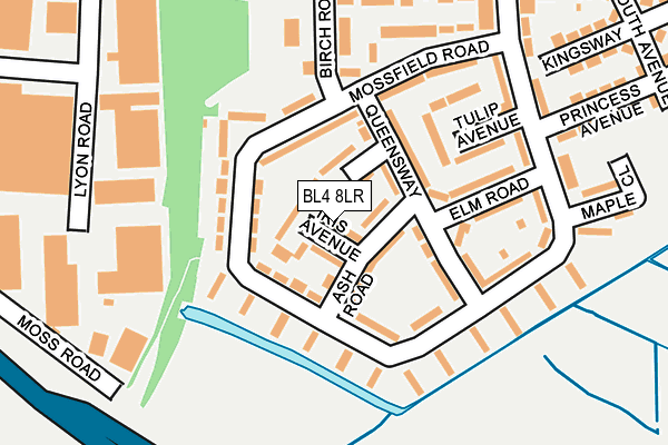
BL4 8LR lies on Iris Avenue in Kearsley, Bolton. BL4 8LR is located in the Kearsley electoral ward, within the metropolitan district of Bolton and the English Parliamentary constituency of Bolton South East. The Sub Integrated Care Board (ICB) Location is NHS Greater Manchester ICB - 00T and the police force is Greater Manchester. This postcode has been in use since January 1980.


GetTheData
Source: OS OpenMap – Local (Ordnance Survey)
Source: OS VectorMap District (Ordnance Survey)
Licence: Open Government Licence (requires attribution)
| Easting | 374639 |
| Northing | 404408 |
| Latitude | 53.535705 |
| Longitude | -2.384113 |
GetTheData
Source: Open Postcode Geo
Licence: Open Government Licence
| Street | Iris Avenue |
| Locality | Kearsley |
| Town/City | Bolton |
| Country | England |
| Postcode District | BL4 |
➜ See where BL4 is on a map ➜ Where is Kearsley? | |
GetTheData
Source: Land Registry Price Paid Data
Licence: Open Government Licence
Elevation or altitude of BL4 8LR as distance above sea level:
| Metres | Feet | |
|---|---|---|
| Elevation | 100m | 328ft |
Elevation is measured from the approximate centre of the postcode, to the nearest point on an OS contour line from OS Terrain 50, which has contour spacing of ten vertical metres.
➜ How high above sea level am I? Find the elevation of your current position using your device's GPS.
GetTheData
Source: Open Postcode Elevation
Licence: Open Government Licence
| Ward | Kearsley |
| Constituency | Bolton South East |
GetTheData
Source: ONS Postcode Database
Licence: Open Government Licence
| Pilkington Road/Melville Road (Pilkington Road) | Kearsley | 283m |
| Pilkington Road/Melville Road (Pilkington Road) | Kearsley | 292m |
| Springfield Road/South Avenue (Springfield Rd) | Kearsley | 308m |
| Springfield Rd/Melville Rd (Springfield Rd) | Kearsley | 311m |
| Pilkington Road/St Kilda Avenue (Pilkington Road) | Kearsley | 485m |
| Kearsley Station | 1.1km |
| Farnworth Station | 1.6km |
| Walkden Station | 1.9km |
GetTheData
Source: NaPTAN
Licence: Open Government Licence
| Percentage of properties with Next Generation Access | 100.0% |
| Percentage of properties with Superfast Broadband | 100.0% |
| Percentage of properties with Ultrafast Broadband | 100.0% |
| Percentage of properties with Full Fibre Broadband | 0.0% |
Superfast Broadband is between 30Mbps and 300Mbps
Ultrafast Broadband is > 300Mbps
| Median download speed | 100.0Mbps |
| Average download speed | 102.3Mbps |
| Maximum download speed | 350.00Mbps |
| Median upload speed | 6.7Mbps |
| Average upload speed | 6.5Mbps |
| Maximum upload speed | 13.56Mbps |
| Percentage of properties unable to receive 2Mbps | 0.0% |
| Percentage of properties unable to receive 5Mbps | 0.0% |
| Percentage of properties unable to receive 10Mbps | 0.0% |
| Percentage of properties unable to receive 30Mbps | 0.0% |
GetTheData
Source: Ofcom
Licence: Ofcom Terms of Use (requires attribution)
Estimated total energy consumption in BL4 8LR by fuel type, 2015.
| Consumption (kWh) | 314,919 |
|---|---|
| Meter count | 30 |
| Mean (kWh/meter) | 10,497 |
| Median (kWh/meter) | 9,070 |
| Consumption (kWh) | 88,460 |
|---|---|
| Meter count | 26 |
| Mean (kWh/meter) | 3,402 |
| Median (kWh/meter) | 3,111 |
GetTheData
Source: Postcode level gas estimates: 2015 (experimental)
Source: Postcode level electricity estimates: 2015 (experimental)
Licence: Open Government Licence
GetTheData
Source: ONS Postcode Database
Licence: Open Government Licence


➜ Get more ratings from the Food Standards Agency
GetTheData
Source: Food Standards Agency
Licence: FSA terms & conditions
| Last Collection | |||
|---|---|---|---|
| Location | Mon-Fri | Sat | Distance |
| Bridgeman Street/Fletcher St | 17:40 | 11:20 | 1,108m |
| Farnworth Station | 18:00 | 11:05 | 1,414m |
| Linneyshaw P.o. | 17:30 | 12:00 | 1,436m |
GetTheData
Source: Dracos
Licence: Creative Commons Attribution-ShareAlike
The below table lists the International Territorial Level (ITL) codes (formerly Nomenclature of Territorial Units for Statistics (NUTS) codes) and Local Administrative Units (LAU) codes for BL4 8LR:
| ITL 1 Code | Name |
|---|---|
| TLD | North West (England) |
| ITL 2 Code | Name |
| TLD3 | Greater Manchester |
| ITL 3 Code | Name |
| TLD36 | Greater Manchester North West |
| LAU 1 Code | Name |
| E08000001 | Bolton |
GetTheData
Source: ONS Postcode Directory
Licence: Open Government Licence
The below table lists the Census Output Area (OA), Lower Layer Super Output Area (LSOA), and Middle Layer Super Output Area (MSOA) for BL4 8LR:
| Code | Name | |
|---|---|---|
| OA | E00024848 | |
| LSOA | E01004907 | Bolton 034D |
| MSOA | E02001017 | Bolton 034 |
GetTheData
Source: ONS Postcode Directory
Licence: Open Government Licence
| BL4 8LS | Ash Road | 52m |
| BL4 8LX | Mossfield Road | 71m |
| BL4 8LP | Queensway | 98m |
| BL4 8LU | Mossfield Road | 104m |
| BL4 8LT | Mossfield Road | 114m |
| BL4 8LL | Elm Road | 133m |
| BL4 8LY | Birch Road | 155m |
| BL4 8LJ | Tulip Avenue | 155m |
| BL4 8LH | Mossfield Road | 156m |
| BL4 8LN | Mossfield Road | 173m |
GetTheData
Source: Open Postcode Geo; Land Registry Price Paid Data
Licence: Open Government Licence