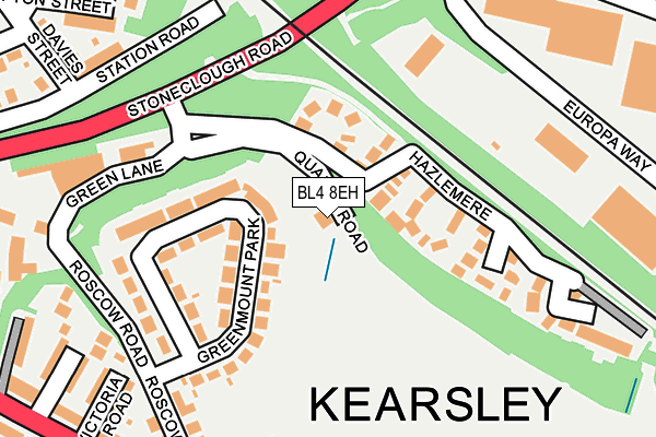
BL4 8EH lies on Quarry Road in Kearsley, Bolton. BL4 8EH is located in the Kearsley electoral ward, within the metropolitan district of Bolton and the English Parliamentary constituency of Bolton South East. The Sub Integrated Care Board (ICB) Location is NHS Greater Manchester ICB - 00T and the police force is Greater Manchester. This postcode has been in use since January 1980.


GetTheData
Source: OS OpenMap – Local (Ordnance Survey)
Source: OS VectorMap District (Ordnance Survey)
Licence: Open Government Licence (requires attribution)
| Easting | 375327 |
| Northing | 405142 |
| Latitude | 53.542351 |
| Longitude | -2.373789 |
GetTheData
Source: Open Postcode Geo
Licence: Open Government Licence
| Street | Quarry Road |
| Locality | Kearsley |
| Town/City | Bolton |
| Country | England |
| Postcode District | BL4 |
➜ See where BL4 is on a map ➜ Where is Kearsley? | |
GetTheData
Source: Land Registry Price Paid Data
Licence: Open Government Licence
Elevation or altitude of BL4 8EH as distance above sea level:
| Metres | Feet | |
|---|---|---|
| Elevation | 80m | 262ft |
Elevation is measured from the approximate centre of the postcode, to the nearest point on an OS contour line from OS Terrain 50, which has contour spacing of ten vertical metres.
➜ How high above sea level am I? Find the elevation of your current position using your device's GPS.
GetTheData
Source: Open Postcode Elevation
Licence: Open Government Licence
| Ward | Kearsley |
| Constituency | Bolton South East |
GetTheData
Source: ONS Postcode Database
Licence: Open Government Licence
| Stoneclough Rd/Europa Way (Stoneclough Rd) | Kearsley | 216m |
| Stoneclough Road/Europa Way (Stoneclough Rd) | Kearsley | 232m |
| Clifton St/Grosvenor St (Clifton St) | Kearsley | 324m |
| Manchester Road/Springfield Road (Manchester Road) | Kearsley | 345m |
| Manchester Rd/Springfield Rd (Manchester Rd) | Kearsley | 345m |
| Kearsley Station | 0.2km |
| Farnworth Station | 1.3km |
| Moses Gate Station | 2.4km |
GetTheData
Source: NaPTAN
Licence: Open Government Licence
| Percentage of properties with Next Generation Access | 100.0% |
| Percentage of properties with Superfast Broadband | 100.0% |
| Percentage of properties with Ultrafast Broadband | 0.0% |
| Percentage of properties with Full Fibre Broadband | 0.0% |
Superfast Broadband is between 30Mbps and 300Mbps
Ultrafast Broadband is > 300Mbps
| Percentage of properties unable to receive 2Mbps | 0.0% |
| Percentage of properties unable to receive 5Mbps | 0.0% |
| Percentage of properties unable to receive 10Mbps | 0.0% |
| Percentage of properties unable to receive 30Mbps | 0.0% |
GetTheData
Source: Ofcom
Licence: Ofcom Terms of Use (requires attribution)
GetTheData
Source: ONS Postcode Database
Licence: Open Government Licence


➜ Get more ratings from the Food Standards Agency
GetTheData
Source: Food Standards Agency
Licence: FSA terms & conditions
| Last Collection | |||
|---|---|---|---|
| Location | Mon-Fri | Sat | Distance |
| Farnworth Station | 18:00 | 11:05 | 1,559m |
| 375 Ringley Road West | 17:30 | 12:00 | 1,614m |
| Bridgeman Street/Fletcher St | 17:40 | 11:20 | 1,620m |
GetTheData
Source: Dracos
Licence: Creative Commons Attribution-ShareAlike
The below table lists the International Territorial Level (ITL) codes (formerly Nomenclature of Territorial Units for Statistics (NUTS) codes) and Local Administrative Units (LAU) codes for BL4 8EH:
| ITL 1 Code | Name |
|---|---|
| TLD | North West (England) |
| ITL 2 Code | Name |
| TLD3 | Greater Manchester |
| ITL 3 Code | Name |
| TLD36 | Greater Manchester North West |
| LAU 1 Code | Name |
| E08000001 | Bolton |
GetTheData
Source: ONS Postcode Directory
Licence: Open Government Licence
The below table lists the Census Output Area (OA), Lower Layer Super Output Area (LSOA), and Middle Layer Super Output Area (MSOA) for BL4 8EH:
| Code | Name | |
|---|---|---|
| OA | E00024827 | |
| LSOA | E01004903 | Bolton 034A |
| MSOA | E02001017 | Bolton 034 |
GetTheData
Source: ONS Postcode Directory
Licence: Open Government Licence
| BL4 8NS | Greenmount Park | 82m |
| BL4 8NU | Greenmount Park | 108m |
| BL4 8EG | Hazlemere | 115m |
| BL4 8NT | Greenmount Park | 170m |
| BL4 8NX | Roscow Road | 210m |
| M26 1HE | Stoneclough Road | 253m |
| BL4 8NR | Victoria Road | 260m |
| BL4 8QQ | Manchester Road | 265m |
| BL4 8DU | Barnes Terrace | 273m |
| BL4 8NW | Alexandra Road | 275m |
GetTheData
Source: Open Postcode Geo; Land Registry Price Paid Data
Licence: Open Government Licence