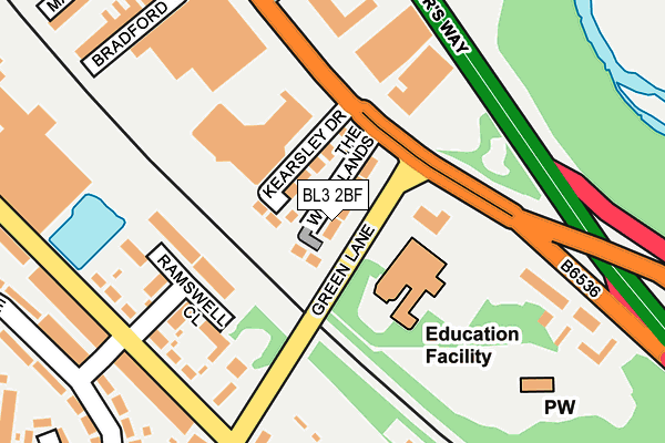
BL3 2BF is located in the Great Lever electoral ward, within the metropolitan district of Bolton and the English Parliamentary constituency of Bolton South East. The Sub Integrated Care Board (ICB) Location is NHS Greater Manchester ICB - 00T and the police force is Greater Manchester. This postcode has been in use since August 2016.


GetTheData
Source: OS OpenMap – Local (Ordnance Survey)
Source: OS VectorMap District (Ordnance Survey)
Licence: Open Government Licence (requires attribution)
| Easting | 372928 |
| Northing | 407248 |
| Latitude | 53.561161 |
| Longitude | -2.410172 |
GetTheData
Source: Open Postcode Geo
Licence: Open Government Licence
| Country | England |
| Postcode District | BL3 |
➜ See where BL3 is on a map ➜ Where is Bolton? | |
GetTheData
Source: Land Registry Price Paid Data
Licence: Open Government Licence
Elevation or altitude of BL3 2BF as distance above sea level:
| Metres | Feet | |
|---|---|---|
| Elevation | 100m | 328ft |
Elevation is measured from the approximate centre of the postcode, to the nearest point on an OS contour line from OS Terrain 50, which has contour spacing of ten vertical metres.
➜ How high above sea level am I? Find the elevation of your current position using your device's GPS.
GetTheData
Source: Open Postcode Elevation
Licence: Open Government Licence
| Ward | Great Lever |
| Constituency | Bolton South East |
GetTheData
Source: ONS Postcode Database
Licence: Open Government Licence
2021 30 JUN £400,000 |
7, WOODLANDS PLACE, BOLTON, BL3 2BF 2017 28 JUL £270,000 |
5, WOODLANDS PLACE, BOLTON, BL3 2BF 2017 2 FEB £295,000 |
2016 22 DEC £295,000 |
3, WOODLANDS PLACE, BOLTON, BL3 2BF 2016 21 DEC £295,000 |
GetTheData
Source: HM Land Registry Price Paid Data
Licence: Contains HM Land Registry data © Crown copyright and database right 2025. This data is licensed under the Open Government Licence v3.0.
| Manchester Rd/Green Ln (Manchester Rd) | Burnden | 115m |
| Manchester Rd/Green Ln (Manchester Rd) | Burnden | 124m |
| Crescent Rd/Green Ln (Crescent Rd) | Burnden | 203m |
| Manchester Road/St Peters Way (Manchester Road) | Burnden | 216m |
| Crescent Rd/Bramhall St (Crescent Rd) | Burnden | 216m |
| Moses Gate Station | 0.8km |
| Bolton Station | 1.8km |
| Farnworth Station | 1.9km |
GetTheData
Source: NaPTAN
Licence: Open Government Licence
| Percentage of properties with Next Generation Access | 100.0% |
| Percentage of properties with Superfast Broadband | 100.0% |
| Percentage of properties with Ultrafast Broadband | 100.0% |
| Percentage of properties with Full Fibre Broadband | 0.0% |
Superfast Broadband is between 30Mbps and 300Mbps
Ultrafast Broadband is > 300Mbps
| Median download speed | 100.0Mbps |
| Average download speed | 93.6Mbps |
| Maximum download speed | 159.86Mbps |
| Median upload speed | 20.0Mbps |
| Average upload speed | 18.1Mbps |
| Maximum upload speed | 30.02Mbps |
| Percentage of properties unable to receive 2Mbps | 0.0% |
| Percentage of properties unable to receive 5Mbps | 0.0% |
| Percentage of properties unable to receive 10Mbps | 0.0% |
| Percentage of properties unable to receive 30Mbps | 0.0% |
GetTheData
Source: Ofcom
Licence: Ofcom Terms of Use (requires attribution)
GetTheData
Source: ONS Postcode Database
Licence: Open Government Licence


➜ Get more ratings from the Food Standards Agency
GetTheData
Source: Food Standards Agency
Licence: FSA terms & conditions
| Last Collection | |||
|---|---|---|---|
| Location | Mon-Fri | Sat | Distance |
| 87 Cawdor Street | 17:40 | 12:50 | 716m |
| Bradford Ave | 16:40 | 12:00 | 908m |
| Egerton Street/Gladstone Road | 17:50 | 11:55 | 1,233m |
GetTheData
Source: Dracos
Licence: Creative Commons Attribution-ShareAlike
The below table lists the International Territorial Level (ITL) codes (formerly Nomenclature of Territorial Units for Statistics (NUTS) codes) and Local Administrative Units (LAU) codes for BL3 2BF:
| ITL 1 Code | Name |
|---|---|
| TLD | North West (England) |
| ITL 2 Code | Name |
| TLD3 | Greater Manchester |
| ITL 3 Code | Name |
| TLD36 | Greater Manchester North West |
| LAU 1 Code | Name |
| E08000001 | Bolton |
GetTheData
Source: ONS Postcode Directory
Licence: Open Government Licence
The below table lists the Census Output Area (OA), Lower Layer Super Output Area (LSOA), and Middle Layer Super Output Area (MSOA) for BL3 2BF:
| Code | Name | |
|---|---|---|
| OA | E00024382 | |
| LSOA | E01004812 | Bolton 022B |
| MSOA | E02001005 | Bolton 022 |
GetTheData
Source: ONS Postcode Directory
Licence: Open Government Licence
| BL3 2PG | Kearsley Drive | 46m |
| BL3 2PH | Green Lane | 86m |
| BL3 2NL | Ramswell Close | 125m |
| BL3 2NF | Ramswell Close | 162m |
| BL3 2NA | Crescent Road | 190m |
| BL3 2LY | Green Lane | 202m |
| BL3 2PQ | Manchester Road | 226m |
| BL3 2LZ | Crescent Road | 250m |
| BL3 2PF | Bradford Avenue | 267m |
| BL3 2LT | Crescent Road | 268m |
GetTheData
Source: Open Postcode Geo; Land Registry Price Paid Data
Licence: Open Government Licence