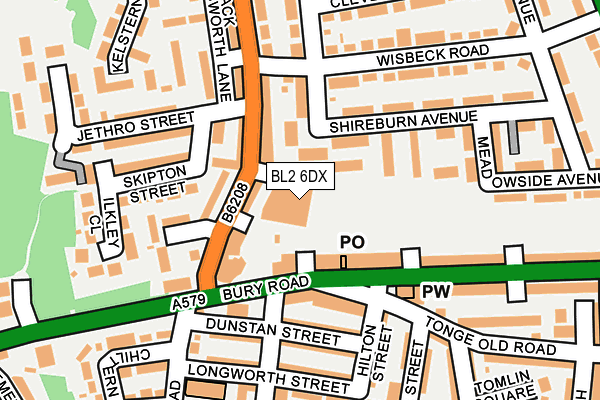
BL2 6DX is located in the Tonge with the Haulgh electoral ward, within the metropolitan district of Bolton and the English Parliamentary constituency of Bolton North East. The Sub Integrated Care Board (ICB) Location is NHS Greater Manchester ICB - 00T and the police force is Greater Manchester. This postcode has been in use since January 1983.


GetTheData
Source: OS OpenMap – Local (Ordnance Survey)
Source: OS VectorMap District (Ordnance Survey)
Licence: Open Government Licence (requires attribution)
| Easting | 373221 |
| Northing | 409482 |
| Latitude | 53.581240 |
| Longitude | -2.405943 |
GetTheData
Source: Open Postcode Geo
Licence: Open Government Licence
| Country | England |
| Postcode District | BL2 |
➜ See where BL2 is on a map ➜ Where is Bolton? | |
GetTheData
Source: Land Registry Price Paid Data
Licence: Open Government Licence
Elevation or altitude of BL2 6DX as distance above sea level:
| Metres | Feet | |
|---|---|---|
| Elevation | 90m | 295ft |
Elevation is measured from the approximate centre of the postcode, to the nearest point on an OS contour line from OS Terrain 50, which has contour spacing of ten vertical metres.
➜ How high above sea level am I? Find the elevation of your current position using your device's GPS.
GetTheData
Source: Open Postcode Elevation
Licence: Open Government Licence
| Ward | Tonge With The Haulgh |
| Constituency | Bolton North East |
GetTheData
Source: ONS Postcode Database
Licence: Open Government Licence
| Bury Rd/Tonge Fold Post Office (Bury Road) | Tonge Fold | 75m |
| Bury Rd/Tonge Fold Post Office (Bury Road) | Tonge Fold | 98m |
| Ainsworth Lane/Ainsworth Court (Ainsworth Lane) | Tonge Fold | 100m |
| Ainsworth Lane/Wisbeck Road (Ainsworth Lane) | Tonge Fold | 128m |
| Ainsworth Lane/Wisbeck Road (Ainsworth Lane) | Tonge Fold | 171m |
| Bolton Station | 1.5km |
| Hall i' th' Wood Station | 1.9km |
| Moses Gate Station | 2.8km |
GetTheData
Source: NaPTAN
Licence: Open Government Licence
GetTheData
Source: ONS Postcode Database
Licence: Open Government Licence


➜ Get more ratings from the Food Standards Agency
GetTheData
Source: Food Standards Agency
Licence: FSA terms & conditions
| Last Collection | |||
|---|---|---|---|
| Location | Mon-Fri | Sat | Distance |
| Tonge Fold P O | 17:05 | 11:25 | 97m |
| 55 Archer Avenue | 17:35 | 11:50 | 505m |
| Ainsworth Lane P O | 17:20 | 12:00 | 534m |
GetTheData
Source: Dracos
Licence: Creative Commons Attribution-ShareAlike
The below table lists the International Territorial Level (ITL) codes (formerly Nomenclature of Territorial Units for Statistics (NUTS) codes) and Local Administrative Units (LAU) codes for BL2 6DX:
| ITL 1 Code | Name |
|---|---|
| TLD | North West (England) |
| ITL 2 Code | Name |
| TLD3 | Greater Manchester |
| ITL 3 Code | Name |
| TLD36 | Greater Manchester North West |
| LAU 1 Code | Name |
| E08000001 | Bolton |
GetTheData
Source: ONS Postcode Directory
Licence: Open Government Licence
The below table lists the Census Output Area (OA), Lower Layer Super Output Area (LSOA), and Middle Layer Super Output Area (MSOA) for BL2 6DX:
| Code | Name | |
|---|---|---|
| OA | E00024946 | |
| LSOA | E01004931 | Bolton 017E |
| MSOA | E02001000 | Bolton 017 |
GetTheData
Source: ONS Postcode Directory
Licence: Open Government Licence
| BL2 2PN | Ainsworth Lane | 66m |
| BL2 2SX | Shireburn Avenue | 66m |
| BL2 6BB | Bury Road | 69m |
| BL2 2ST | Stanley Park Walk | 70m |
| BL2 6AY | Bury Road | 102m |
| BL2 2PP | Ainsworth Lane | 119m |
| BL2 6BH | Tonge Old Road | 126m |
| BL2 2SU | Shireburn Avenue | 126m |
| BL2 6AT | Dunstan Street | 150m |
| BL2 6AU | Dunstan Street | 151m |
GetTheData
Source: Open Postcode Geo; Land Registry Price Paid Data
Licence: Open Government Licence