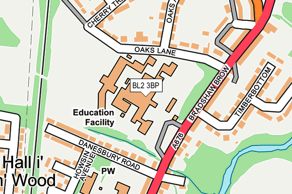
BL2 3BP is located in the Bromley Cross electoral ward, within the metropolitan district of Bolton and the English Parliamentary constituency of Bolton North East. The Sub Integrated Care Board (ICB) Location is NHS Greater Manchester ICB - 00T and the police force is Greater Manchester. This postcode has been in use since July 1983.


GetTheData
Source: OS OpenMap – Local (Ordnance Survey)
Source: OS VectorMap District (Ordnance Survey)
Licence: Open Government Licence (requires attribution)
| Easting | 373025 |
| Northing | 411807 |
| Latitude | 53.602127 |
| Longitude | -2.409106 |
GetTheData
Source: Open Postcode Geo
Licence: Open Government Licence
| Country | England |
| Postcode District | BL2 |
➜ See where BL2 is on a map ➜ Where is Bolton? | |
GetTheData
Source: Land Registry Price Paid Data
Licence: Open Government Licence
Elevation or altitude of BL2 3BP as distance above sea level:
| Metres | Feet | |
|---|---|---|
| Elevation | 120m | 394ft |
Elevation is measured from the approximate centre of the postcode, to the nearest point on an OS contour line from OS Terrain 50, which has contour spacing of ten vertical metres.
➜ How high above sea level am I? Find the elevation of your current position using your device's GPS.
GetTheData
Source: Open Postcode Elevation
Licence: Open Government Licence
| Ward | Bromley Cross |
| Constituency | Bolton North East |
GetTheData
Source: ONS Postcode Database
Licence: Open Government Licence
| Canon Slade High School (Canon Slade Sch) | Bradshaw | 51m |
| Canon Slade High School (Canon Slade Sch) | Bradshaw | 64m |
| Canon Slade Hs | Bradshaw | 65m |
| Canon Slade High School (Canon Slade Sch) | Bradshaw | 76m |
| Canon Slade High School (Canon Slade Sch) | Bradshaw | 83m |
| Hall i' th' Wood Station | 0.6km |
| Bromley Cross Station | 1.3km |
| Bolton Station | 3.3km |
GetTheData
Source: NaPTAN
Licence: Open Government Licence
GetTheData
Source: ONS Postcode Database
Licence: Open Government Licence


➜ Get more ratings from the Food Standards Agency
GetTheData
Source: Food Standards Agency
Licence: FSA terms & conditions
| Last Collection | |||
|---|---|---|---|
| Location | Mon-Fri | Sat | Distance |
| Castle Hill | 17:50 | 12:20 | 766m |
| Bromley Cross Station | 18:00 | 12:10 | 1,357m |
| Bromley Cross P O | 18:45 | 12:15 | 1,541m |
GetTheData
Source: Dracos
Licence: Creative Commons Attribution-ShareAlike
The below table lists the International Territorial Level (ITL) codes (formerly Nomenclature of Territorial Units for Statistics (NUTS) codes) and Local Administrative Units (LAU) codes for BL2 3BP:
| ITL 1 Code | Name |
|---|---|
| TLD | North West (England) |
| ITL 2 Code | Name |
| TLD3 | Greater Manchester |
| ITL 3 Code | Name |
| TLD36 | Greater Manchester North West |
| LAU 1 Code | Name |
| E08000001 | Bolton |
GetTheData
Source: ONS Postcode Directory
Licence: Open Government Licence
The below table lists the Census Output Area (OA), Lower Layer Super Output Area (LSOA), and Middle Layer Super Output Area (MSOA) for BL2 3BP:
| Code | Name | |
|---|---|---|
| OA | E00024340 | |
| LSOA | E01004810 | Bolton 002E |
| MSOA | E02000985 | Bolton 002 |
GetTheData
Source: ONS Postcode Directory
Licence: Open Government Licence
| BL2 3BR | Oaks Lane | 131m |
| BL2 3AU | Danesbury Road | 146m |
| BL2 3DD | Bradshaw Brow | 149m |
| BL2 3DJ | Back Bradshaw Brow | 186m |
| BL2 3AS | Howsin Avenue | 205m |
| BL2 3BS | Cherry Tree Way | 206m |
| BL2 3DG | Timberbottom | 207m |
| BL2 3BZ | Oaks Avenue | 209m |
| BL2 3DF | Galindo Street | 212m |
| BL2 3DB | Bradshaw Brow | 226m |
GetTheData
Source: Open Postcode Geo; Land Registry Price Paid Data
Licence: Open Government Licence