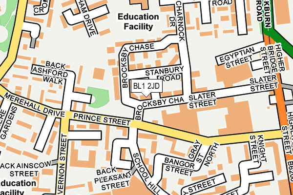
BL1 2JD lies on Brocksby Chase in Bolton. BL1 2JD is located in the Halliwell electoral ward, within the metropolitan district of Bolton and the English Parliamentary constituency of Bolton North East. The Sub Integrated Care Board (ICB) Location is NHS Greater Manchester ICB - 00T and the police force is Greater Manchester. This postcode has been in use since January 2008.


GetTheData
Source: OS OpenMap – Local (Ordnance Survey)
Source: OS VectorMap District (Ordnance Survey)
Licence: Open Government Licence (requires attribution)
| Easting | 371383 |
| Northing | 409987 |
| Latitude | 53.585681 |
| Longitude | -2.433750 |
GetTheData
Source: Open Postcode Geo
Licence: Open Government Licence
| Street | Brocksby Chase |
| Town/City | Bolton |
| Country | England |
| Postcode District | BL1 |
➜ See where BL1 is on a map ➜ Where is Bolton? | |
GetTheData
Source: Land Registry Price Paid Data
Licence: Open Government Licence
Elevation or altitude of BL1 2JD as distance above sea level:
| Metres | Feet | |
|---|---|---|
| Elevation | 110m | 361ft |
Elevation is measured from the approximate centre of the postcode, to the nearest point on an OS contour line from OS Terrain 50, which has contour spacing of ten vertical metres.
➜ How high above sea level am I? Find the elevation of your current position using your device's GPS.
GetTheData
Source: Open Postcode Elevation
Licence: Open Government Licence
| Ward | Halliwell |
| Constituency | Bolton North East |
GetTheData
Source: ONS Postcode Database
Licence: Open Government Licence
| Prince Street/School Hill (Prince Street) | Brownlow Fold | 59m |
| Vernon Street/Mossfield Court (Vernon Street) | Brownlow Fold | 206m |
| Vernon Street/Mossfield Court (Vernon Street) | Brownlow Fold | 206m |
| Merehall Drive/Petersfield Walk (Merehall Drive) | Brownlow Fold | 215m |
| Higher Bridge Street/Slater Street (Higher Bridge S) | Bolton | 261m |
| Bolton Station | 1.4km |
| Hall i' th' Wood Station | 1.9km |
| Bromley Cross Station | 3.5km |
GetTheData
Source: NaPTAN
Licence: Open Government Licence
| Percentage of properties with Next Generation Access | 100.0% |
| Percentage of properties with Superfast Broadband | 100.0% |
| Percentage of properties with Ultrafast Broadband | 100.0% |
| Percentage of properties with Full Fibre Broadband | 0.0% |
Superfast Broadband is between 30Mbps and 300Mbps
Ultrafast Broadband is > 300Mbps
| Percentage of properties unable to receive 2Mbps | 0.0% |
| Percentage of properties unable to receive 5Mbps | 0.0% |
| Percentage of properties unable to receive 10Mbps | 0.0% |
| Percentage of properties unable to receive 30Mbps | 0.0% |
GetTheData
Source: Ofcom
Licence: Ofcom Terms of Use (requires attribution)
Estimated total energy consumption in BL1 2JD by fuel type, 2015.
| Consumption (kWh) | 39,273 |
|---|---|
| Meter count | 9 |
| Mean (kWh/meter) | 4,364 |
| Median (kWh/meter) | 4,324 |
| Consumption (kWh) | 19,306 |
|---|---|
| Meter count | 9 |
| Mean (kWh/meter) | 2,145 |
| Median (kWh/meter) | 2,585 |
GetTheData
Source: Postcode level gas estimates: 2015 (experimental)
Source: Postcode level electricity estimates: 2015 (experimental)
Licence: Open Government Licence
GetTheData
Source: ONS Postcode Database
Licence: Open Government Licence


➜ Get more ratings from the Food Standards Agency
GetTheData
Source: Food Standards Agency
Licence: FSA terms & conditions
| Last Collection | |||
|---|---|---|---|
| Location | Mon-Fri | Sat | Distance |
| Bolton North Delivery Office | 18:45 | 589m | |
| Cable Street | 17:40 | 12:25 | 617m |
| Knowsley Street | 19:15 | 11:50 | 646m |
GetTheData
Source: Dracos
Licence: Creative Commons Attribution-ShareAlike
The below table lists the International Territorial Level (ITL) codes (formerly Nomenclature of Territorial Units for Statistics (NUTS) codes) and Local Administrative Units (LAU) codes for BL1 2JD:
| ITL 1 Code | Name |
|---|---|
| TLD | North West (England) |
| ITL 2 Code | Name |
| TLD3 | Greater Manchester |
| ITL 3 Code | Name |
| TLD36 | Greater Manchester North West |
| LAU 1 Code | Name |
| E08000001 | Bolton |
GetTheData
Source: ONS Postcode Directory
Licence: Open Government Licence
The below table lists the Census Output Area (OA), Lower Layer Super Output Area (LSOA), and Middle Layer Super Output Area (MSOA) for BL1 2JD:
| Code | Name | |
|---|---|---|
| OA | E00024435 | |
| LSOA | E01033220 | Bolton 016F |
| MSOA | E02000999 | Bolton 016 |
GetTheData
Source: ONS Postcode Directory
Licence: Open Government Licence
| BL1 2JE | Brocksby Chase | 37m |
| BL1 2LF | Stanbury Road | 63m |
| BL1 2JZ | Callthorpe Close | 77m |
| BL1 2JH | Brocksby Chase | 84m |
| BL1 2NL | School Hill | 114m |
| BL1 2XA | Weybridge Close | 132m |
| BL1 2XD | Redhill Grove | 144m |
| BL1 2RF | Mossfield Court | 146m |
| BL1 2XB | Thornbury Close | 150m |
| BL1 2HT | Charnock Drive | 165m |
GetTheData
Source: Open Postcode Geo; Land Registry Price Paid Data
Licence: Open Government Licence