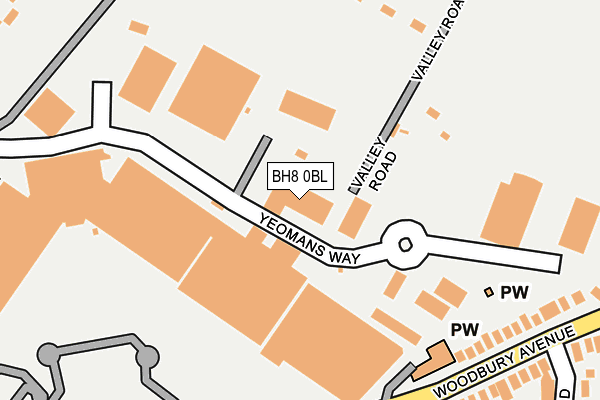
BH8 0BL is located in the Muscliff & Strouden Park electoral ward, within the unitary authority of Bournemouth, Christchurch and Poole and the English Parliamentary constituency of Bournemouth East. The Sub Integrated Care Board (ICB) Location is NHS Dorset ICB - 11J and the police force is Dorset. This postcode has been in use since February 2011.


GetTheData
Source: OS OpenMap – Local (Ordnance Survey)
Source: OS VectorMap District (Ordnance Survey)
Licence: Open Government Licence (requires attribution)
| Easting | 411457 |
| Northing | 94935 |
| Latitude | 50.753902 |
| Longitude | -1.838952 |
GetTheData
Source: Open Postcode Geo
Licence: Open Government Licence
| Country | England |
| Postcode District | BH8 |
➜ See where BH8 is on a map ➜ Where is Bournemouth? | |
GetTheData
Source: Land Registry Price Paid Data
Licence: Open Government Licence
Elevation or altitude of BH8 0BL as distance above sea level:
| Metres | Feet | |
|---|---|---|
| Elevation | 10m | 33ft |
Elevation is measured from the approximate centre of the postcode, to the nearest point on an OS contour line from OS Terrain 50, which has contour spacing of ten vertical metres.
➜ How high above sea level am I? Find the elevation of your current position using your device's GPS.
GetTheData
Source: Open Postcode Elevation
Licence: Open Government Licence
| Ward | Muscliff & Strouden Park |
| Constituency | Bournemouth East |
GetTheData
Source: ONS Postcode Database
Licence: Open Government Licence
| Eventide Homes (Woodbury Avenue) | Strouden | 245m |
| B And Q (Woodbury Avenue) | Strouden | 249m |
| Castlepoint Centre (Hamblin Way) | Strouden | 282m |
| Craigmore Road (Castle Lane West) | Strouden | 363m |
| Craigmore Road (Castle Lane West) | Strouden | 365m |
| Pokesdown Station | 2.7km |
| Bournemouth Station | 3.5km |
| Christchurch Station | 4.2km |
GetTheData
Source: NaPTAN
Licence: Open Government Licence
GetTheData
Source: ONS Postcode Database
Licence: Open Government Licence
➜ Get more ratings from the Food Standards Agency
GetTheData
Source: Food Standards Agency
Licence: FSA terms & conditions
| Last Collection | |||
|---|---|---|---|
| Location | Mon-Fri | Sat | Distance |
| Bradpole Post Office | 17:30 | 12:00 | 405m |
| Ibbertson Road | 17:30 | 12:00 | 553m |
| Holdenhurst | 17:30 | 11:45 | 555m |
GetTheData
Source: Dracos
Licence: Creative Commons Attribution-ShareAlike
The below table lists the International Territorial Level (ITL) codes (formerly Nomenclature of Territorial Units for Statistics (NUTS) codes) and Local Administrative Units (LAU) codes for BH8 0BL:
| ITL 1 Code | Name |
|---|---|
| TLK | South West (England) |
| ITL 2 Code | Name |
| TLK2 | Dorset and Somerset |
| ITL 3 Code | Name |
| TLK24 | Bournemouth, Christchurch and Poole |
| LAU 1 Code | Name |
| E06000058 | Bournemouth, Christchurch and Poole |
GetTheData
Source: ONS Postcode Directory
Licence: Open Government Licence
The below table lists the Census Output Area (OA), Lower Layer Super Output Area (LSOA), and Middle Layer Super Output Area (MSOA) for BH8 0BL:
| Code | Name | |
|---|---|---|
| OA | E00077550 | |
| LSOA | E01015341 | Bournemouth 008D |
| MSOA | E02003179 | Bournemouth 008 |
GetTheData
Source: ONS Postcode Directory
Licence: Open Government Licence
| BH8 0HH | Woodbury Avenue | 255m |
| BH8 0HJ | Woodbury Avenue | 269m |
| BH8 0HX | Culford Close | 295m |
| BH8 0LY | Stacey Gardens | 329m |
| BH8 0HL | Woodbury Avenue | 330m |
| BH8 0HP | Hastings Road | 335m |
| BH8 0HN | Hastings Road | 338m |
| BH8 9TR | Castle Lane West | 364m |
| BH8 0HU | Barrow Road | 372m |
| BH8 9UE | Castle Lane West | 376m |
GetTheData
Source: Open Postcode Geo; Land Registry Price Paid Data
Licence: Open Government Licence