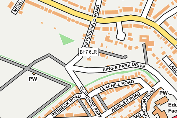
BH7 6LR is located in the Littledown & Iford electoral ward, within the unitary authority of Bournemouth, Christchurch and Poole and the English Parliamentary constituency of Bournemouth East. The Sub Integrated Care Board (ICB) Location is NHS Dorset ICB - 11J and the police force is Dorset. This postcode has been in use since January 1980.


GetTheData
Source: OS OpenMap – Local (Ordnance Survey)
Source: OS VectorMap District (Ordnance Survey)
Licence: Open Government Licence (requires attribution)
| Easting | 412423 |
| Northing | 92741 |
| Latitude | 50.734153 |
| Longitude | -1.825332 |
GetTheData
Source: Open Postcode Geo
Licence: Open Government Licence
| Country | England |
| Postcode District | BH7 |
➜ See where BH7 is on a map ➜ Where is Bournemouth? | |
GetTheData
Source: Land Registry Price Paid Data
Licence: Open Government Licence
Elevation or altitude of BH7 6LR as distance above sea level:
| Metres | Feet | |
|---|---|---|
| Elevation | 30m | 98ft |
Elevation is measured from the approximate centre of the postcode, to the nearest point on an OS contour line from OS Terrain 50, which has contour spacing of ten vertical metres.
➜ How high above sea level am I? Find the elevation of your current position using your device's GPS.
GetTheData
Source: Open Postcode Elevation
Licence: Open Government Licence
| Ward | Littledown & Iford |
| Constituency | Bournemouth East |
GetTheData
Source: ONS Postcode Database
Licence: Open Government Licence
| Durrington Road (Petersfield Road) | Iford | 193m |
| Durrington Road (Petersfield Road) | Iford | 209m |
| Spurgeon Road (Christchurch Road) | Pokesdown | 312m |
| Spurgeon Road (Christchurch Road) | Pokesdown | 329m |
| Pokesdown Station Restricted Use (Christchurch Road) | Pokesdown | 352m |
| Pokesdown Station | 0.3km |
| Bournemouth Station | 2.9km |
| Christchurch Station | 2.9km |
GetTheData
Source: NaPTAN
Licence: Open Government Licence
GetTheData
Source: ONS Postcode Database
Licence: Open Government Licence


➜ Get more ratings from the Food Standards Agency
GetTheData
Source: Food Standards Agency
Licence: FSA terms & conditions
| Last Collection | |||
|---|---|---|---|
| Location | Mon-Fri | Sat | Distance |
| Clarence Road | 17:30 | 12:30 | 219m |
| 37 Harewood Ave | 17:00 | 12:15 | 230m |
| Christchurch Road | 17:30 | 12:30 | 336m |
GetTheData
Source: Dracos
Licence: Creative Commons Attribution-ShareAlike
The below table lists the International Territorial Level (ITL) codes (formerly Nomenclature of Territorial Units for Statistics (NUTS) codes) and Local Administrative Units (LAU) codes for BH7 6LR:
| ITL 1 Code | Name |
|---|---|
| TLK | South West (England) |
| ITL 2 Code | Name |
| TLK2 | Dorset and Somerset |
| ITL 3 Code | Name |
| TLK24 | Bournemouth, Christchurch and Poole |
| LAU 1 Code | Name |
| E06000058 | Bournemouth, Christchurch and Poole |
GetTheData
Source: ONS Postcode Directory
Licence: Open Government Licence
The below table lists the Census Output Area (OA), Lower Layer Super Output Area (LSOA), and Middle Layer Super Output Area (MSOA) for BH7 6LR:
| Code | Name | |
|---|---|---|
| OA | E00077437 | |
| LSOA | E01015314 | Bournemouth 011A |
| MSOA | E02003182 | Bournemouth 011 |
GetTheData
Source: ONS Postcode Directory
Licence: Open Government Licence
| BH7 6QE | Petersfield Road | 73m |
| BH7 6NU | Harewood Place | 131m |
| BH7 6LU | Leaphill Road | 132m |
| BH7 6LS | Leaphill Road | 144m |
| BH7 6LF | Clarence Park Road | 147m |
| BH7 6LQ | Clarence Park Road | 159m |
| BH7 6NL | Harewood Avenue | 160m |
| BH7 6LW | Rebbeck Road | 165m |
| BH7 6NN | Harewood Avenue | 176m |
| BH7 6LX | Abinger Road | 176m |
GetTheData
Source: Open Postcode Geo; Land Registry Price Paid Data
Licence: Open Government Licence