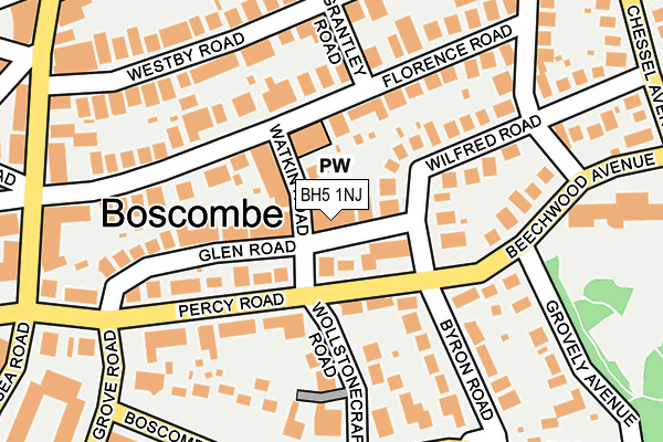
BH5 1NJ lies on Glen Road in Bournemouth. BH5 1NJ is located in the Boscombe West electoral ward, within the unitary authority of Bournemouth, Christchurch and Poole and the English Parliamentary constituency of Bournemouth East. The Sub Integrated Care Board (ICB) Location is NHS Dorset ICB - 11J and the police force is Dorset. This postcode has been in use since February 2004.


GetTheData
Source: OS OpenMap – Local (Ordnance Survey)
Source: OS VectorMap District (Ordnance Survey)
Licence: Open Government Licence (requires attribution)
| Easting | 411623 |
| Northing | 91590 |
| Latitude | 50.723819 |
| Longitude | -1.836703 |
GetTheData
Source: Open Postcode Geo
Licence: Open Government Licence
| Street | Glen Road |
| Town/City | Bournemouth |
| Country | England |
| Postcode District | BH5 |
➜ See where BH5 is on a map ➜ Where is Bournemouth? | |
GetTheData
Source: Land Registry Price Paid Data
Licence: Open Government Licence
Elevation or altitude of BH5 1NJ as distance above sea level:
| Metres | Feet | |
|---|---|---|
| Elevation | 30m | 98ft |
Elevation is measured from the approximate centre of the postcode, to the nearest point on an OS contour line from OS Terrain 50, which has contour spacing of ten vertical metres.
➜ How high above sea level am I? Find the elevation of your current position using your device's GPS.
GetTheData
Source: Open Postcode Elevation
Licence: Open Government Licence
| Ward | Boscombe West |
| Constituency | Bournemouth East |
GetTheData
Source: ONS Postcode Database
Licence: Open Government Licence
| Wollstonecraft Road (Boscombe Cliff Road) | Boscombe | 215m |
| Wollstonecraft Road (Boscombe Cliff Road) | Boscombe | 226m |
| Michelgrove Road (Boscombe Cliff Road) | Boscombe | 247m |
| Hawkwood Road Car Park (Hawkwood Road) | Boscombe | 269m |
| Percy Road (Sea Road) | Boscombe | 272m |
| Pokesdown Station | 1.2km |
| Bournemouth Station | 2km |
| Christchurch Station | 4km |
GetTheData
Source: NaPTAN
Licence: Open Government Licence
| Percentage of properties with Next Generation Access | 100.0% |
| Percentage of properties with Superfast Broadband | 100.0% |
| Percentage of properties with Ultrafast Broadband | 100.0% |
| Percentage of properties with Full Fibre Broadband | 0.0% |
Superfast Broadband is between 30Mbps and 300Mbps
Ultrafast Broadband is > 300Mbps
| Percentage of properties unable to receive 2Mbps | 0.0% |
| Percentage of properties unable to receive 5Mbps | 0.0% |
| Percentage of properties unable to receive 10Mbps | 0.0% |
| Percentage of properties unable to receive 30Mbps | 0.0% |
GetTheData
Source: Ofcom
Licence: Ofcom Terms of Use (requires attribution)
GetTheData
Source: ONS Postcode Database
Licence: Open Government Licence


➜ Get more ratings from the Food Standards Agency
GetTheData
Source: Food Standards Agency
Licence: FSA terms & conditions
| Last Collection | |||
|---|---|---|---|
| Location | Mon-Fri | Sat | Distance |
| Woolstonecraft Road | 17:30 | 12:45 | 104m |
| 40 Westby Road | 17:30 | 12:45 | 205m |
| 3 Florence Road | 17:30 | 12:45 | 223m |
GetTheData
Source: Dracos
Licence: Creative Commons Attribution-ShareAlike
The below table lists the International Territorial Level (ITL) codes (formerly Nomenclature of Territorial Units for Statistics (NUTS) codes) and Local Administrative Units (LAU) codes for BH5 1NJ:
| ITL 1 Code | Name |
|---|---|
| TLK | South West (England) |
| ITL 2 Code | Name |
| TLK2 | Dorset and Somerset |
| ITL 3 Code | Name |
| TLK24 | Bournemouth, Christchurch and Poole |
| LAU 1 Code | Name |
| E06000058 | Bournemouth, Christchurch and Poole |
GetTheData
Source: ONS Postcode Directory
Licence: Open Government Licence
The below table lists the Census Output Area (OA), Lower Layer Super Output Area (LSOA), and Middle Layer Super Output Area (MSOA) for BH5 1NJ:
| Code | Name | |
|---|---|---|
| OA | E00077224 | |
| LSOA | E01015280 | Bournemouth 019C |
| MSOA | E02003190 | Bournemouth 019 |
GetTheData
Source: ONS Postcode Directory
Licence: Open Government Licence
| BH5 1HP | Watkin Road | 14m |
| BH5 1HS | Glen Road | 14m |
| BH5 1JG | Percy Road | 48m |
| BH5 1ND | Wilfred Road | 110m |
| BH5 1EH | Florence Road | 120m |
| BH5 1ER | Florence Road | 132m |
| BH5 1HJ | Florence Road | 138m |
| BH5 1JF | Percy Road | 141m |
| BH5 1JQ | Wollstonecraft Road | 142m |
| BH5 1HG | Florence Road | 148m |
GetTheData
Source: Open Postcode Geo; Land Registry Price Paid Data
Licence: Open Government Licence